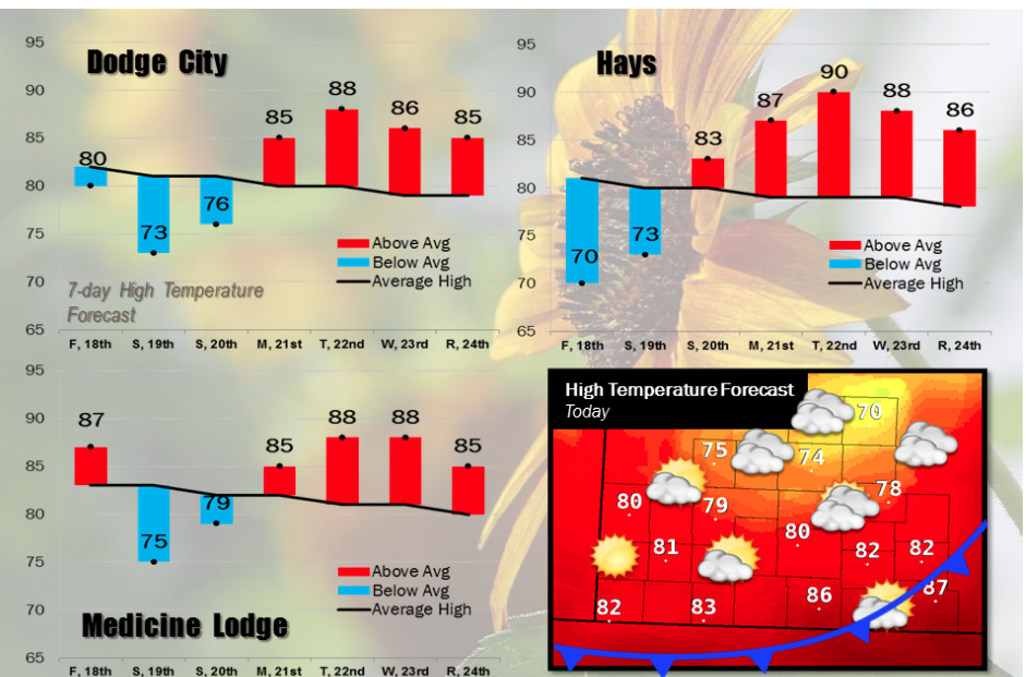
A fairly strong cold front will be pushing through southwest Kansas today. Much cooler temperatures will move in from the north, along with low clouds. The extensive low cloud cover will keep temperatures in the 60s to lower 70s across much of northern and central Kansas, including Wakeeney and Hays, where highs will only be around 70. Ahead of the front in far south central Kansas, afternoon temperatures will top out in the upper 80s. Strong to severe thunderstorms will develop along the front, but should remain southeast of our region, including Barber County. Below average temperatures will occur Saturday and Sunday with temperatures warming back up above average next week.
 Today Mostly cloudy, with a high near 73. East northeast wind 14 to 17 mph becoming north in the afternoon.
Tonight Mostly cloudy, then gradually becoming mostly clear, with a low around 50. North wind 8 to 18 mph, with gusts as high as 28 mph.
SaturdayMostly sunny, with a high near 80. North wind 6 to 9 mph becoming east southeast in the afternoon.
Saturday NightA 20 percent chance of showers and thunderstorms after 4am. Partly cloudy, with a low around 54. East southeast wind 7 to 10 mph.
SundayA 30 percent chance of showers and thunderstorms, mainly after 8am. Mostly sunny, with a high near 83. South wind 7 to 11 mph.
Sunday NightA 30 percent chance of showers and thunderstorms before 8pm. Mostly clear, with a low around 55.
MondaySunny, with a high near 86.