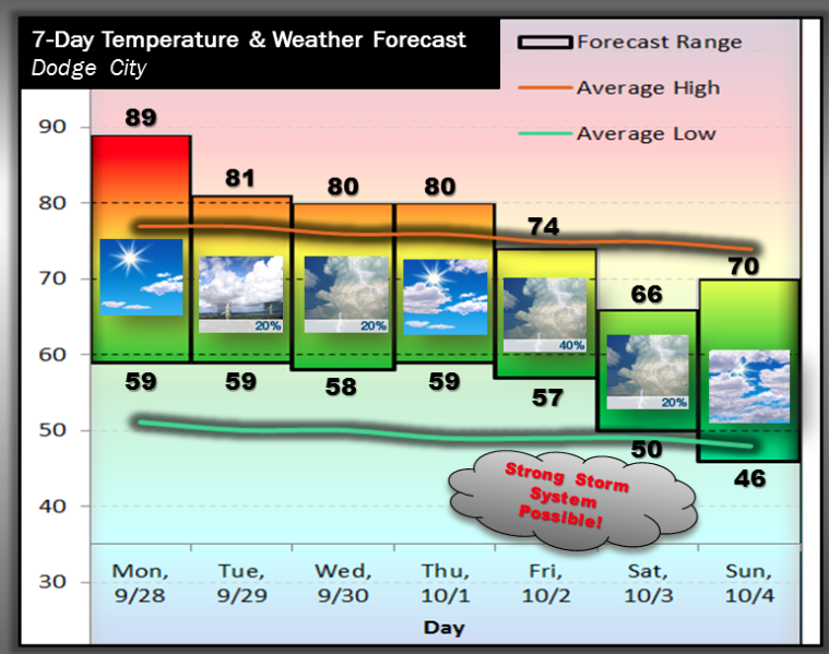
A very warm day is in store across western Kansas today. A cold front will approach late tonight into Tuesday before stalling out. There will likely be a fairly sharp temperature gradient across the Central Plains Tuesday and Wednesday. Dodge City should be on the warm side of the front through Wednesday, but the cooler air will gain momentum by the end of the week. A fairly strong storm will likely cross the Rockies late in the week leading to a favorable environment for an organized precipitation event across the Central Plains, including southwest Kansas
 Today Sunny, with a high near 89. South wind 6 to 13 mph.
Tonight A 20 percent chance of showers and thunderstorms after 3am. Partly cloudy, with a low around 59. South southeast wind 8 to 10 mph.
TuesdayA 40 percent chance of showers and thunderstorms. Mostly cloudy, with a high near 73. East northeast wind 7 to 14 mph.
Tuesday NightA 30 percent chance of showers and thunderstorms, mainly before 1am. Mostly cloudy, with a low around 57. East northeast wind 9 to 14 mph.
WednesdayA 40 percent chance of showers and thunderstorms, mainly after 8am. Mostly cloudy, with a high near 76. South southeast wind 9 to 15 mph.
Wednesday NightA 20 percent chance of showers and thunderstorms before 10pm. Partly cloudy, with a low around 58.
ThursdayPartly sunny, with a high near 77.