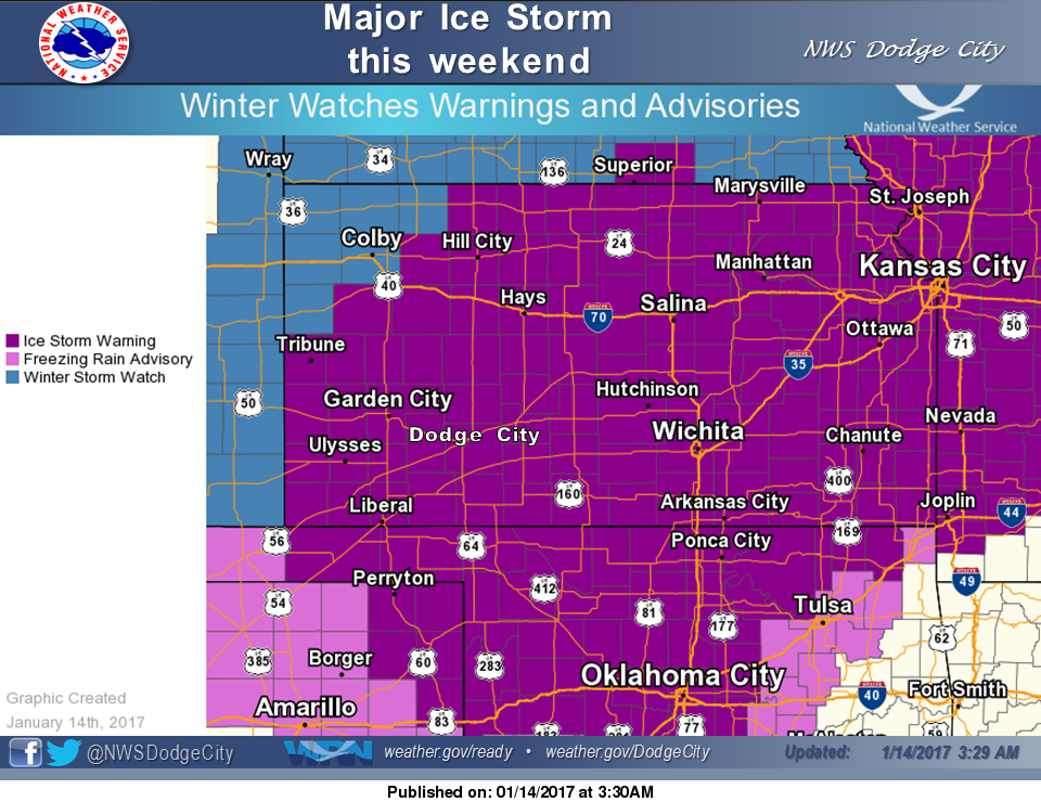
 An ice storm warning remains in effect this weekend:
Today
A chance of sleet after 11am, mixing with freezing rain after 3pm. Cloudy, with a high near 30. Calm wind becoming east northeast around 5 mph in the afternoon. Chance of precipitation is 30%.
Tonight
A chance of freezing rain and sleet before 7pm, then freezing rain likely. Cloudy, with a low around 24. East wind 3 to 5 mph. Chance of precipitation is 70%. New ice accumulation of 0.1 to 0.3 of an inch possible. Little or no sleet accumulation expected.
Sunday
Freezing rain, possibly mixed with sleet, becoming all freezing rain after 4pm. High near 27. East wind 5 to 8 mph. Chance of precipitation is 80%. New ice accumulation of 0.1 to 0.3 of an inch possible. Little or no sleet accumulation expected.
Sunday Night
Freezing rain before 3am, then sleet, possibly mixed with freezing rain. Temperature rising to around 31 by 4am. Northeast wind 7 to 10 mph. Chance of precipitation is 80%. New sleet accumulation of less than a half inch possible.
M.L.King Day
Rain, snow, freezing rain, and sleet likely before 1pm, then a chance of rain, snow, and sleet between 1pm and 2pm, then a chance of rain and snow after 2pm. Cloudy, with a high near 34. North northwest wind 10 to 15 mph. Chance of precipitation is 70%. New precipitation amounts between a tenth and quarter of an inch possible.
Monday Night
Mostly cloudy, with a low around 23.
Tuesday
Sunny, with a high near 42.
Tuesday Night
Mostly clear, with a low around 24.
Wednesday
Sunny, with a high near 52.