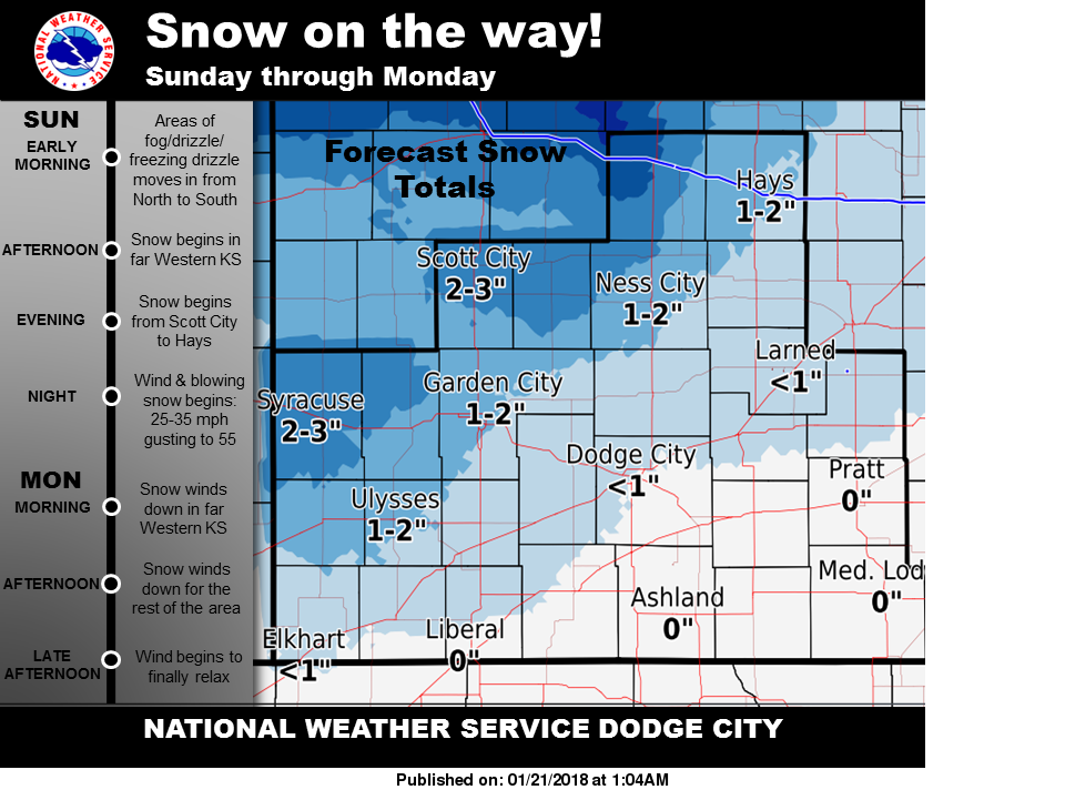
 Snow is likely Sunday night through Monday. One of the biggest impacts may be blowing snow beginning late Sunday night through Monday (especially Monday morning) with wind speeds of 25-35 mph, gusting to 55. Make sure you stay weather aware.
Today
A slight chance of drizzle before 11am, then rain likely. Widespread dense fog, mainly before 10am. Otherwise, cloudy, with a high near 40. North wind 9 to 15 mph, with gusts as high as 25 mph. Chance of precipitation is 70%. Little or no ice accumulation expected.
Tonight
Snow likely, mainly before 4am. Areas of blowing snow. Cloudy, with a low around 26. Windy, with a north northwest wind 16 to 21 mph increasing to 23 to 28 mph after midnight. Winds could gust as high as 40 mph. Chance of precipitation is 70%. New snow accumulation of 1 to 2 inches possible.
Monday
A 40 percent chance of snow, mainly before 10am. Areas of blowing snow before 11am. Cloudy through mid morning, then gradual clearing, with a high near 40. Very windy, with a north northwest wind 22 to 31 mph, with gusts as high as 41 mph.
Monday Night
Mostly clear, with a low around 21. Blustery, with a west northwest wind 15 to 20 mph decreasing to 9 to 14 mph after midnight.
Tuesday
Sunny, with a high near 44. Northwest wind 8 to 11 mph.
Tuesday Night
Mostly clear, with a low around 20.
Wednesday
Sunny, with a high near 51.
Wednesday Night
Mostly clear, with a low around 25.
Thursday
Sunny, with a high near 59.