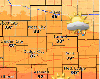
Today Mostly sunny, with a high near 86. North northwest wind 5 to 8 mph becoming east in the afternoon.
Severe weather forecast for later this afternoon and evening. There is potential for up to tennis ball size hail, damaging up to 75mph and an isolated tornado or two. Storms will develop in eastern CO and push into KS after 5PM and will expand eastward through the evening hours. pic.twitter.com/4WN97GsXbR
— NWS Dodge City (@NWSDodgeCity) June 22, 2018
Tonight Showers and thunderstorms likely, mainly before 11pm. Some of the storms could be severe. Increasing clouds, with a low around 61. East wind 5 to 11 mph. Chance of precipitation is 60%. New rainfall amounts between a quarter and half of an inch possible.
Saturday Mostly sunny, with a high near 88. Northwest wind around 6 mph becoming west southwest in the morning.
Saturday Night Mostly clear, with a low around 65. Southwest wind around 7 mph becoming east southeast in the evening.
Sunday A 40 percent chance of showers and thunderstorms after 1pm. Partly sunny, with a high near 88. Southeast wind 6 to 14 mph, with gusts as high as 24 mph.
Sunday Night Showers and thunderstorms likely, mainly before 1am. Some of the storms could produce heavy rainfall. Mostly cloudy, with a low around 65. Chance of precipitation is 70%. New rainfall amounts between 1 and 2 inches possible.