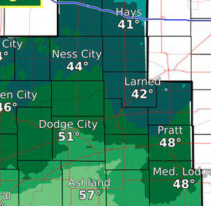
Today Patchy fog before 8am. Patchy freezing fog before 8am. Otherwise, cloudy through mid morning, then gradual clearing, with a high near 41. Light and variable wind becoming southwest 5 to 8 mph in the morning.
Tonight Mostly cloudy, with a low around 30. South wind 7 to 15 mph.
FridayRain likely, possibly mixed with snow, becoming all snow after 4pm. Cloudy, with a temperature rising to near 41 by 10am, then falling to around 32 during the remainder of the day. Breezy, with an east northeast wind 8 to 13 mph becoming north 19 to 24 mph in the afternoon. Chance of precipitation is 60%. New snow accumulation of less than a half inch possible.
Friday NightA 50 percent chance of snow before midnight. Patchy blowing snow before midnight. Mostly cloudy, with a low around 15. Wind chill values as low as -2. Windy, with a north wind 23 to 28 mph, with gusts as high as 38 mph. New snow accumulation of 1 to 2 inches possible.
SaturdayMostly sunny, with a high near 26. Blustery, with a north wind 17 to 22 mph decreasing to 7 to 12 mph in the afternoon.
Saturday NightMostly clear, with a low around 14.