 Forecasters are now calling for about a half-inch of snow in the Hays area Friday evening and overnight.
The projected cold front arrived Friday afternoon, with temperatures beginning to dip and winds picking up.
John Finch of the NWS Dodge City office said meteorologists are still working on precisely projecting this particular front.
“There’s a big difference between having flurries and having an inch as far as impact,” he said. “We think it’s going to snow … but is it trace or an inch and it blows all over the place?”

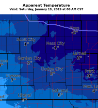
After the potential for snow ends overnight, the highs Saturday will be in the 20s, with the lows in the teens. Early Saturday, winds are expected to be in the 20 to 30 mph range, driving wind chills down to around zero in the Hays area, according to the NWS.
From there, the mercury will begin to yo-yo — temperatures in the 40s on Sunday and Monday, colder on Tuesday, and chilling again on Wednesday.
“Not brutally cold,” Finch said. “Just your typical cold front for this time of year.”
Click HERE for the complete extended forecast.