Tuesday Rain likely, mainly before 1pm. Cloudy, with a high near 56. Breezy, with a south wind 10 to 15 mph increasing to 16 to 21 mph in the afternoon. Chance of precipitation is 70%. New precipitation amounts between a tenth and quarter of an inch possible.
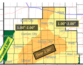
Rain, heavy at times, can be expected over the next few days. Rainfall totals of 1 to 2 inches will be possible which may result in localized flooding. A flood watch is in effect for Tuesday night and Wednesday. Strong winds will develop during the day on Wednesday. #kswx pic.twitter.com/bzJYfp70yE
— NWS Dodge City (@NWSDodgeCity) March 11, 2019
Tuesday Night Showers and possibly a thunderstorm. Some of the storms could produce heavy rain. Low around 49. South southeast wind 14 to 16 mph. Chance of precipitation is 80%. New rainfall amounts between a half and three quarters of an inch possible.
Wednesday Periods of showers and possibly a thunderstorm. Some of the storms could produce heavy rain. High near 58. Very windy, with an east southeast wind 20 to 25 mph increasing to 27 to 32 mph in the afternoon. Winds could gust as high as 46 mph. Chance of precipitation is 80%. New rainfall amounts between a half and three quarters of an inch possible.
Wednesday NightRain showers likely before 3am, then scattered rain and snow showers. Cloudy, with a low around 34. Very windy, with a south wind 26 to 31 mph becoming northwest 35 to 40 mph in the evening. Winds could gust as high as 60 mph. Chance of precipitation is 60%. New precipitation amounts of less than a tenth of an inch possible.
ThursdayA chance of rain and snow showers before noon, then scattered rain showers between noon and 1pm. Cloudy, with a high near 40. Very windy. Chance of precipitation is 30%.
Thursday NightMostly cloudy, with a low around 25. Very windy.
FridaySunny, with a high near 44.