NWS

DODGE CITY – The National Weather Service in Dodge City has issued a High Wind Warning for Ellis County and much of western Kansas from 1 p.m. today through 1 p.m. Thursday.
Affected counties:Kansas
Trego-Ellis-Scott-Lane-Ness-Rush-Hamilton-Kearny-Finney-Hodgeman-Pawnee-Stafford-Stanton-Grant-Haskell-Gray-Ford-Edwards-Kiowa-Pratt-Morton-Stevens-Seward-Meade-Clark-Comanche-Barber
Including the cities of WaKeeney, Pfeifer, Hays, Scott City, Scott State Lake, Dighton, Ness City, La Crosse, Syracuse, Lakin, Deerfield, Garden City, Jetmore, Hanston, Larned, St. John, Stafford, Macksville, Johnson City, Ulysses, Sublette, Satanta, Cimarron, Montezuma, Dodge City, Kinsley, Lewis, Greensburg, Haviland, Pratt, Elkhart, Hugoton, Liberal, Meade, Plains City, Fowler, Ashland, Minneola, Coldwater, Lake Coldwater, Protection,
Medicine Lodge, and Kiowa.
1105 AM CDT Tue Mar 12 2019 /1005 AM MDT Tue Mar 12 2019/
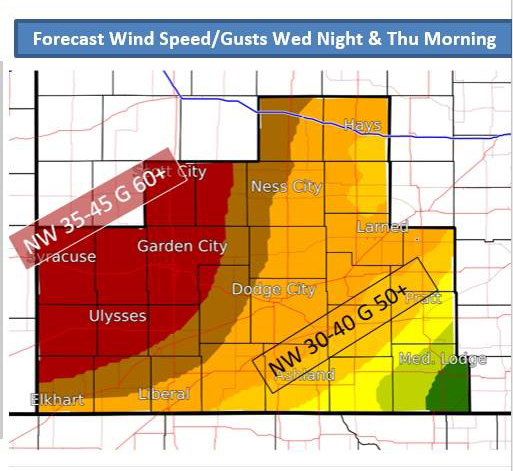
…HIGH WIND WARNING IN EFFECT FROM 1 PM CDT /NOON MDT/ WEDNESDAY TO 1 PM CDT /NOON MDT/ THURSDAY…
* TIMING…From 1 pm Wednesday through 1 pm Thursday.
* WINDS…40 to 50 mph with 60 to 65 mph gusts.
* IMPACTS…Driving will be hazardous, especially on east-west oriented highways, and for those traveling in
high- profile vehicles.
PRECAUTIONARY/PREPAREDNESS ACTIONS…
A High Wind Warning means a hazardous high wind event is expected or occurring. Sustained wind speeds of at least 40 mph or gusts of 58 mph or more can lead to property damage.