Monday A 30 percent chance of showers and thunderstorms, mainly after 1pm. Mostly cloudy, with a high near 65. Northeast wind 9 to 11 mph.
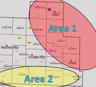
The atmosphere is supportive of an isolated supercell this afternoon and evening. Conditions are very favorable for giant hail. #kswx pic.twitter.com/Nv8bEn0uF9
— NWS Dodge City (@NWSDodgeCity) May 5, 2019
Monday Night Showers and thunderstorms likely. Cloudy, with a low around 50. Northeast wind around 11 mph. Chance of precipitation is 70%. New rainfall amounts between a quarter and half of an inch possible.
Tuesday Showers and thunderstorms likely, mainly before 1pm. Cloudy, with a high near 61. East northeast wind 11 to 13 mph. Chance of precipitation is 60%. New rainfall amounts between a tenth and quarter of an inch, except higher amounts possible in thunderstorms.
Tuesday NightShowers and possibly a thunderstorm before 1am, then showers and thunderstorms likely after 1am. Low around 52. East wind 9 to 11 mph. Chance of precipitation is 80%. New rainfall amounts between a half and three quarters of an inch possible.
WednesdayShowers and thunderstorms likely, mainly after 1pm. Cloudy, with a high near 63. Chance of precipitation is 70%. New rainfall amounts between a quarter and half of an inch possible.
Wednesday NightA 50 percent chance of showers and thunderstorms before 1am. Cloudy, with a low around 42. Breezy.
ThursdayMostly cloudy, with a high near 58.