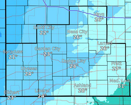

The cold front blowing into the region has the potential to bring record overnight lows to western Kansas, according to the National Weather Service in Dodge City.
Northwest winds are expected to continue into Thursday evening, gusting up to 50 mph.
A widespread freeze is expected for most of western Kansas, with temperatures falling below 28 degrees.
“The growing season is expected to end for most locations tonight and Friday morning,” the NWS warned.
The frigid temperatures could come with precipitation, as well, with scattered light snow showers overnight. No accumulation is expected.
The cold is expected to last into Friday, with a high of only 47 predicted. This weekend, moderate temperatures return with highs in the low to mid-60s on Saturday and Sunday.
The band of snow will weaken as it moves east of Colorado this afternoon. The highest snow amounts are expected to be in East Central Colorado, with less to the east. The snow will end by mid evening. Any snow/visibility reports are appreciated. #kswx #newx #cowx pic.twitter.com/C8bARgxgxJ
— NWS Goodland (@NWSGoodland) October 10, 2019