
Be sure to check Hays Post for the latest cancellations and delays through the winter storm season and tune into your Eagle Radio stations for the latest on severe weather.
UPDATED 3:45 p.m. Tuesday
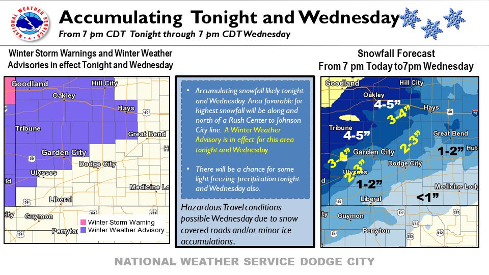
A winter weather advisory is in effect for much of northwest Kansas beginning Tuesday evening.
The warning will remain in effect until 7 p.m. Wednesday, according to the National Weather Service in Dodge City.
There is a 30 percent to 80 percent chance of snow Tuesday, with the temperature dipping into the low 20s. Drifting and blowing snow could occur, as strong north winds will accompany the storm, with steady winds of 25 to 35 mph and gusts near 45 mph.
The NWS said there is a chance for 2 to 5 inches of accumulation, as well as ice possible. The snow is expected to accumulate northwest of a line from Ulysses to Great Bend.
The conditions could make Tuesday evening and Wednesday morning road conditions hazardous and visibility will be reduced.
“This will be the first round of winter driving conditions this season,” the NWS warned. “Motorists are urged to slow down and allow extra time to reach their destination on Wednesday.”
Eastern Colorado could receive as much as 11 inches of accumulation, the NWS in Goodland reported.
Tune into your Eagle Radio stations for the latest on severe weather, as well as cancellations and delays.
Accumulating snow and light ice accumulations possible tonight and Wednesday. Snow accumulations in excess of 2 inches will be possible along and north of a Rush Center to Johnson City line. Winter weather advisories are in effect Tonight and Wednesday for this area. #kswx pic.twitter.com/AgsPmDL5KZ
— NWS Dodge City (@NWSDodgeCity) October 29, 2019
Winter Storm Warning and Winter Weather Advisory in effect mid-day today through mid-day Wednesday. pic.twitter.com/rt9Hjb6iof
— NWS Goodland (@NWSGoodland) October 29, 2019