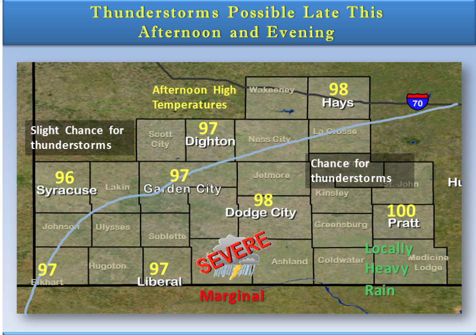
After another afternoon with temperatures climbing into the upper 90s to around 100, isolated to widely scattered thunderstorms will be possible late this afternoon and evening. The better chances will be east of a line from Meade to Hays. A few of the storms could be severe with quarter size hail and damaging winds in excess of 60 mph. Locally heavy rainfall could cause some flooded roads in a few locations.
 Today A chance of showers and thunderstorms before 10am, then a slight chance of showers and thunderstorms after 3pm.
Partly sunny, with a high near 98. Calm wind becoming south southwest around 5 mph in the afternoon. Chance of precipitation is 30%.
Tonight A 20 percent chance of showers and thunderstorms. Partly cloudy, with a low around 70. South wind around 8 mph.
Friday A 20 percent chance of showers and thunderstorms after 4pm. Mostly sunny and hot, with a high near 100. South wind 6 to 15 mph.
Friday Night A slight chance of showers and thunderstorms before 3am, then a slight chance of showers and thunderstorms after 4am. Partly cloudy, with a low around 72. South wind 11 to 16 mph. Chance of precipitation is 20%.
Saturday A 10 percent chance of showers and thunderstorms before 7am. Mostly sunny and hot, with a high near 101.
Saturday Night A 20 percent chance of showers and thunderstorms. Partly cloudy, with a low around 72.
Sunday A 30 percent chance of showers and thunderstorms. Partly sunny, with a high near 92.
Sunday Nigh tA 30 percent chance of showers and thunderstorms. Mostly cloudy, with a low around 67.
Monday Mostly sunny, with a high near 91.