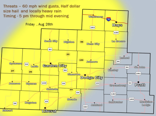
Thunderstorms will develop over eastern Colorado late this afternoon before becoming a threat over western Kansas as early as 5 pm and lasting into the evening. Heavy rain, lightning and gusty winds to around 60 mph are the main threat, with a secondary threat of large hail as half dollars. Not all areas will receive rainfall however, around 50 percent areal coverage of storms and rainfall is possible. A large degree of uncertainty also exists as to whether any of the storms would remain sustained into central Kansas by later in the evening. At this time the best chances for storms appears over the highlighted region.
Today A 20 percent chance of showers and thunderstorms after 9am. Cloudy, with a high near 77. North northwest wind 5 to 11 mph becoming southeast in the afternoon.
 Tonight A 50 percent chance of showers and thunderstorms, mainly before 4am. Mostly cloudy, with a low around 61. East wind 6 to 11 mph.
SaturdayA 20 percent chance of showers and thunderstorms after 4pm. Partly sunny, with a high near 86. North northeast wind 6 to 8 mph becoming southeast in the afternoon.
Saturday NightA 30 percent chance of showers and thunderstorms, mainly after 10pm. Mostly cloudy, with a low around 64. South southeast wind 6 to 11 mph.
SundayA 30 percent chance of showers and thunderstorms. Mostly sunny, with a high near 89. South wind 6 to 11 mph.
Sunday NightA 30 percent chance of showers and thunderstorms. Mostly cloudy, with a low around 66.
MondayA 30 percent chance of showers and thunderstorms. Partly sunny, with a high near 87.