Thursday’s storm brought near hurricane force winds, large hail and heavy rain to Kansas. Just before 2p.m. Thursday, the National Weather Service issued the first of numerous tornado watches and severe weather warnings.
Lorraine, KS…Ellsworth County. Also this…neighbors just down the street. pic.twitter.com/gxCF5we7gb
— Jessica (@jessbowlby) June 16, 2017
Wind gusts of 70 and over 80 miles per hour damaged roofs and toppled trees in many areas of the state. Hail up to softball size was also reported.
Very strong winds moving through Newton. Will affect Wichita and El Dorado as well. 80 mph wind not out of the question. #kswx
— NWS Wichita (@NWSWichita) June 16, 2017
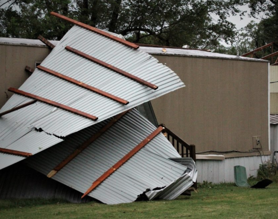
High winds caused damage in Assaria and Southern Saline County Thursday evening. Winds reported up to 60-miles-per-hour ripped the roof off an outbuilding in Assaria.
The building, located on the west end of town, had part of its roof ripped off. The debris landed in the neighboring trailer park, causing damage to several cars and breaking a window on a trailer.

Wind gusts of 57-mph were recorded at the Salina Airport.
According to the National Weather Service, at 5:12 p.m. wind gusts reached 77-mph at Lindsborg Middle School. Reports indicate minor flooding and power outages throughout town.
In Barber County, the Kansas Highway Patrol reported a 2013 Freightliner semi driven by Colin Jay Wespe, 24, El Dorado, was southbound on U.S. 281 at Rattlesnake Trail.
The truck began to slow due to inclement weather. The wind then blew the semi-tractor and trailer onto its side on the ditch. Wespe was transported to the Kiowa County Hospital.