
NWS
DODGE CITY – URGENT – WINTER WEATHER MESSAGE
National Weather Service Dodge City KS
1249 PM CST Tue Jan 9 2018
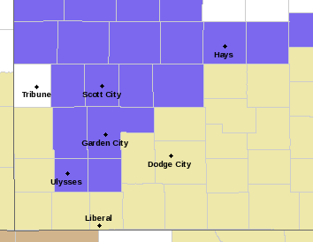
Trego-Ellis-Scott-Lane-Ness-Kearny-Finney-Grant-Haskell
Including the cities of WaKeeney, Pfeifer, Hays, Scott City, Scott State Lake, Dighton, Ness City, Lakin, Deerfield, Garden City, Ulysses, Sublette, and Satanta
1249 PM CST Tue Jan 9 2018
WINTER WEATHER ADVISORY IN EFFECT FROM MIDNIGHT WEDNESDAY NIGHT TO 8 AM CST THURSDAY
The National Weather Service in Dodge City has issued a Winter Weather Advisory for snow, which is in effect from midnight Wednesday night to 8 AM CST Thursday.
* TIMING…Snow will begin in far western Kansas by midnight and then spread eastward. Snow will taper off by 8 am in the Hays area.
* Snow Amounts…Widespread snow accumulations of an inch with localized amounts around 2 inches possible.
* Winds: North winds will increase to 30 to 40 mph with gusts up to 50 mph by midnight. These high winds will cause blowing and
drifting of snow and reduced visibilities to less than a quarter of a mile at times.
* MAIN IMPACT…Strong winds up to 50 mph and blowing snow can be expected to impact travel.
* OTHER IMPACTS…Slick spots will likely develop on highways.
PRECAUTIONARY/PREPAREDNESS ACTIONS…
A Winter Weather Advisory for snow means that periods of snow will cause primarily travel difficulties. Be prepared for snow-covered roads, blowing and drifting of snow and limited visibilities. Use caution while driving.