
NWS
DODGE CITY – URGENT – WINTER WEATHER MESSAGE
National Weather Service Dodge City KS
1210 PM CST Sun Jan 21 2018
KSZ030-031-221200-
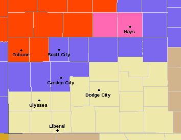
Trego-Ellis-
Including the cities of WaKeeney, Pfeifer, and Hays
1210 PM CST Sun Jan 21 2018
…WINTER STORM WARNING IN EFFECT FROM 8 PM THIS EVENING TO NOON CST MONDAY…

* WHAT…Heavy snow expected. Plan on difficult travel conditions, including during the morning commute on Monday. Damage to trees and power lines is possible. Total snow accumulations of 3 to 6 inches are expected.
* WHERE…Trego and Ellis County.
* WHEN…8 PM tonight to noon Monday.
* ADDITIONAL DETAILS…Strong north winds of 25 to 35 mph with gusts to 50 mph are expected. Be prepared for significant reductions in visibility with local whiteout conditions at times.
PRECAUTIONARY/PREPAREDNESS ACTIONS…
A Winter Storm Warning for snow means severe winter weather conditions are expected. If you must travel, keep an extra flashlight, food and water in your vehicle in case of an emergency. The latest road conditions for the state you are calling from can be obtained by calling 511.