 NWS
NWS
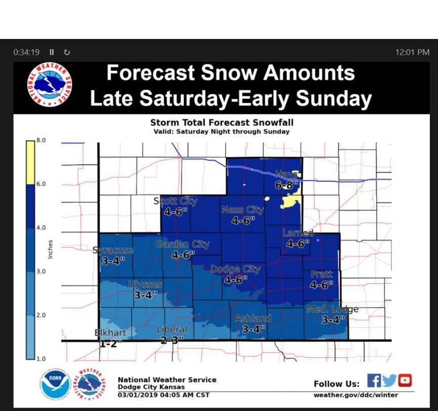
DODGE CITY – Snow and Bitterly Cold Temperatures on the Way…

…WINTER STORM WARNING IN EFFECT FROM 6 PM SATURDAY TO NOON CST
SUNDAY…
Trego-Ellis-Scott-Lane-Ness-Rush-Finney-Hodgeman-Pawnee-Stafford-Gray-Ford-Edwards counties including the cities of WaKeeney, Pfeifer, Hays, Scott City, Scott State Lake, Dighton, Ness City, La Crosse, Garden City, Jetmore, Hanston, Larned, St. John, Stafford, Macksville, Cimarron, Montezuma, Dodge City, Kinsley, and Lewis
* WHAT…Light freezing drizzle and flurries Saturday afternoon are expected to change to all snow Saturday evening, with total snow accumulations of 3 to 6 inches. North winds at 20 to 30 mph, along with gusts as high as 35 mph, will cause blowing and drifting of snow and reduced visibilities under a quarter of a mile at times. Bitterly cold air along with the wind will result in dangerous wind chills as low as -20. Any freezing drizzle that develops ahead of the snow could cause slick spots Saturday afternoon.
* WHERE…Portions of central, south central, southwest and west central Kansas.
* WHEN…From 6 PM Saturday to noon CST Sunday.
* ADDITIONAL DETAILS…Plan on slippery road conditions. Blowing snow could significantly reduce visibility. The cold wind chills as low as 20 below zero could cause frostbite on exposed skin in as little as 30 minutes.
PRECAUTIONARY/PREPAREDNESS ACTIONS…
A Winter Storm Warning for snow means severe winter weather conditions will make travel very hazardous or impossible. If you must travel, keep an extra flashlight, food and water in your vehicle in case of an emergency.
The latest road conditions for the state you are calling from can be obtained by calling 5-1-1.