We have a brand new updated website! Click here to check it out!

Cloudy Wednesday with a chance for thunderstorms


A cold front will move south into Kansas later tonight, acting to dry out the atmosphere and bring and end to rain chances for late Thursday and into Friday. However, in the meantime, another cloudy cool and wet day is in store for all of western and central Kansas today. Cloudy conditions with occasional light showers can be expected through most of the day. Additionally there will be increasing chances for widely scattered heavy rain producing thunderstorms as the atmosphere warms this afternoon.

Today A 40 percent chance of showers and thunderstorms. Areas of fog before 10am. Otherwise, cloudy, with a high near 76. Northeast wind 5 to 8 mph.

Screen Shot 2016-08-31 at 5.22.20 AMTonight A 30 percent chance of showers and thunderstorms, mainly before 8pm. Mostly cloudy, with a low around 58. East northeast wind 5 to 10 mph.

ThursdayMostly cloudy, then gradually becoming sunny, with a high near 79. North northeast wind 6 to 9 mph becoming east in the afternoon.

Thursday NightMostly clear, with a low around 57. East wind 6 to 9 mph.

FridayMostly sunny, with a high near 80.

Friday NightA 20 percent chance of showers and thunderstorms after 1am. Mostly cloudy, with a low around 63.

SaturdayA 20 percent chance of showers and thunderstorms. Partly sunny, with a high near 83. Breezy.
Cloudy, wet Tuesday


Today Showers and thunderstorms likely, mainly after 3pm. Areas of fog before 9am. Otherwise, cloudy, with a high near 79. North northeast wind around 5 mph becoming calm in the morning. Chance of precipitation is 60%. New rainfall amounts between a tenth and quarter of an inch, except higher amounts possible in thunderstorms.

Tonight Showers and thunderstorms likely, mainly before 3am. Cloudy, with a low around 64. East wind 5 to 7 mph becoming north northwest after midnight. Chance of precipitation is 60%. New rainfall amounts between a tenth and quarter of an inch, except higher amounts possible in thunderstorms.

WednesdayA 40 percent chance of showers and thunderstorms. Mostly cloudy, with a high near 78. Northeast wind 6 to 9 mph.

Wednesday NightA 20 percent chance of showers and thunderstorms. Mostly cloudy, with a low around 61. East northeast wind 5 to 10 mph.

ThursdayMostly sunny, with a high near 80.

Thursday NightMostly clear, with a low around 59.

FridayMostly sunny, with a high near 81.

Cloudy, warm Monday with a chance for thunderstorms


Showers and thunderstorms may become widely scattered in areal coverage through the mid morning hours, and lingering through the afternoon. The main threats are lightning and locally heavy rain.

Monday A 40 percent chance of showers and thunderstorms, mainly after 2pm. Mostly cloudy, with a high near 84. Light south southeast wind increasing to 5 to 9 mph in the morning.

Monday Night  A 40 percent chance of showers and thunderstorms. Mostly cloudy, with a low around 65. Southeast wind 5 to 8 mph becoming light and variable after midnight.

Tuesday A 40 percent chance of showers and thunderstorms. Mostly cloudy, with a high near 82. East southeast wind 5 to 8 mph.

Tuesday NightA 50 percent chance of showers and thunderstorms. Mostly cloudy, with a low around 64. East northeast wind 6 to 9 mph.

WednesdayA 50 percent chance of showers and thunderstorms. Mostly cloudy, with a high near 79.

Wednesday NightA 20 percent chance of showers and thunderstorms. Mostly cloudy, with a low around 62.

ThursdayA 20 percent chance of showers and thunderstorms. Partly sunny, with a high near 80.

Thursday NightPartly cloudy, with a low around 62.

FridayMostly sunny, with a high near 82.

Partly cloudy Friday, chance for thunderstorms


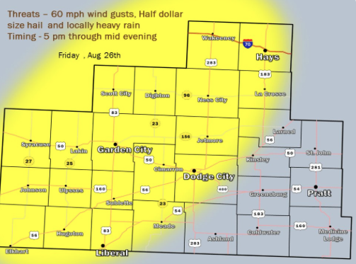
Thunderstorms will develop over eastern Colorado late this afternoon before becoming a threat over western Kansas as early as 5 pm and lasting into the evening. Heavy rain, lightning and gusty winds to around 60 mph are the main threat, with a secondary threat of large hail as half dollars. Not all areas will receive rainfall however, around 50 percent areal coverage of storms and rainfall is possible. A large degree of uncertainty also exists as to whether any of the storms would remain sustained into central Kansas by later in the evening. At this time the best chances for storms appears over the highlighted region.

Today A 20 percent chance of showers and thunderstorms after 9am. Cloudy, with a high near 77. North northwest wind 5 to 11 mph becoming southeast in the afternoon.

Screen Shot 2016-08-26 at 5.46.19 AMTonight A 50 percent chance of showers and thunderstorms, mainly before 4am. Mostly cloudy, with a low around 61. East wind 6 to 11 mph.
SaturdayA 20 percent chance of showers and thunderstorms after 4pm. Partly sunny, with a high near 86. North northeast wind 6 to 8 mph becoming southeast in the afternoon.

Saturday NightA 30 percent chance of showers and thunderstorms, mainly after 10pm. Mostly cloudy, with a low around 64. South southeast wind 6 to 11 mph.

SundayA 30 percent chance of showers and thunderstorms. Mostly sunny, with a high near 89. South wind 6 to 11 mph.

Sunday NightA 30 percent chance of showers and thunderstorms. Mostly cloudy, with a low around 66.

MondayA 30 percent chance of showers and thunderstorms. Partly sunny, with a high near 87.

Cool, wet Thursday

Today A 50 percent chance of showers and thunderstorms, mainly before 2pm. Cloudy, with a high near 72. North northeast wind 8 to 13 mph.

Screen Shot 2016-08-25 at 5.26.47 AMTonight A 40 percent chance of showers and thunderstorms, mainly after 9pm. Mostly cloudy, with a low around 58. East northeast wind 8 to 13 mph.
FridayA 40 percent chance of showers and thunderstorms. Mostly cloudy, with a high near 77. Northeast wind 6 to 8 mph becoming south southeast in the afternoon.

Friday NightA 50 percent chance of showers and thunderstorms. Mostly cloudy, with a low around 62. East wind 5 to 8 mph.

SaturdayA 30 percent chance of showers and thunderstorms, mainly before 2pm. Partly sunny, with a high near 84.

Saturday NightA 40 percent chance of showers and thunderstorms. Mostly cloudy, with a low around 63.

SundayA 30 percent chance of showers and thunderstorms. Mostly sunny, with a high near 86.

Partly cloudy Wednesday, chance for thunderstorms


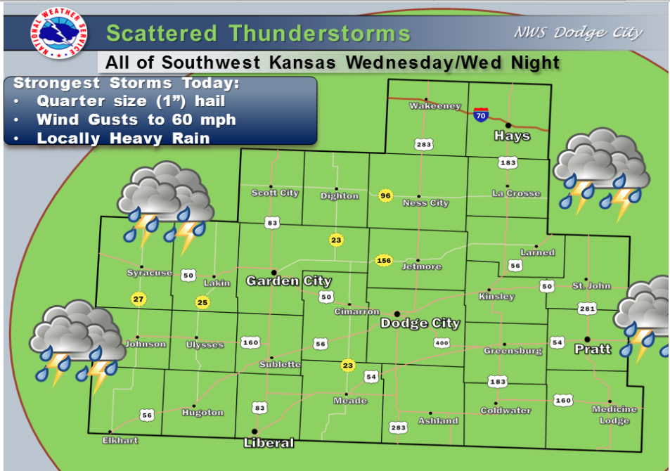
A cold front sagging into the plains will trigger scattered thunderstorms today and tonight. Some storms may be strong to locally severe. Locally heavy rainfall is likely. Behind the front…much cooler 70s are on the way Thursday!

Screen Shot 2016-08-24 at 4.52.09 AMToday A 40 percent chance of showers and thunderstorms, mainly after 2pm. Mostly cloudy, with a high near 82. North wind 7 to 9 mph becoming east northeast in the afternoon.

Tonight Showers and thunderstorms likely, mainly after 3am. Mostly cloudy, with a low around 62. North northeast wind 6 to 9 mph. Chance of precipitation is 60%. New rainfall amounts between a half and three quarters of an inch possible.

ThursdayA 50 percent chance of showers and thunderstorms. Mostly cloudy, with a high near 75. North northeast wind 8 to 11 mph.

Thursday NightA 30 percent chance of showers and thunderstorms, mainly after 2am. Mostly cloudy, with a low around 59. East northeast wind 6 to 10 mph.

FridayA 40 percent chance of showers and thunderstorms. Mostly cloudy, with a high near 77. East northeast wind around 8 mph becoming southeast in the afternoon.

Friday NightA 40 percent chance of showers and thunderstorms. Mostly cloudy, with a low around 64.

SaturdayA 30 percent chance of showers and thunderstorms. Partly sunny, with a high near 86.

Sunny, hot Tuesday with a chance for thunderstorms

Today A slight chance of showers and thunderstorms before 10am, then a slight chance of showers and thunderstorms after noon. Mostly sunny, with a high near 95. Breezy, with a south wind 10 to 20 mph. Chance of precipitation is 20%.

Screen Shot 2016-08-23 at 4.54.03 AMTonight tA slight chance of showers and thunderstorms before midnight, then a slight chance of showers and thunderstorms after 3am. Partly cloudy, with a low around 68. South wind 8 to 13 mph becoming east after midnight. Chance of precipitation is 20%.
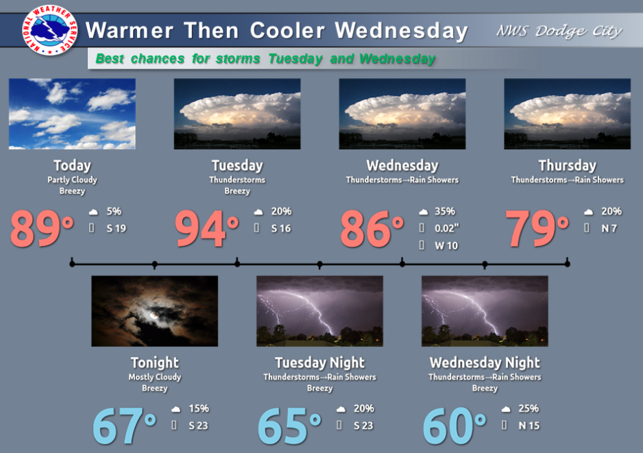
WednesdayA 30 percent chance of showers and thunderstorms, mainly after 8am. Partly sunny, with a high near 83. North northeast wind 7 to 11 mph.

Wednesday NightA 40 percent chance of showers and thunderstorms. Mostly cloudy, with a low around 60. North northeast wind 8 to 14 mph.

ThursdayA 30 percent chance of showers and thunderstorms, mainly before 10am. Mostly cloudy, with a high near 77. East northeast wind 8 to 10 mph.

Thursday NightA 30 percent chance of showers and thunderstorms, mainly after 9pm. Mostly cloudy, with a low around 59.

FridayA 30 percent chance of showers and thunderstorms. Mostly cloudy, with a high near 80.

Friday NightA 40 percent chance of showers and thunderstorms. Mostly cloudy, with a low around 64.

Hot, breezy Monday

Today Sunny, with a high near 88. Breezy, with a south wind 9 to 14 mph increasing to 16 to 21 mph in the afternoon.

Screen Shot 2016-08-22 at 5.00.56 AMTonight Partly cloudy, with a low around 68. South wind 11 to 17 mph.
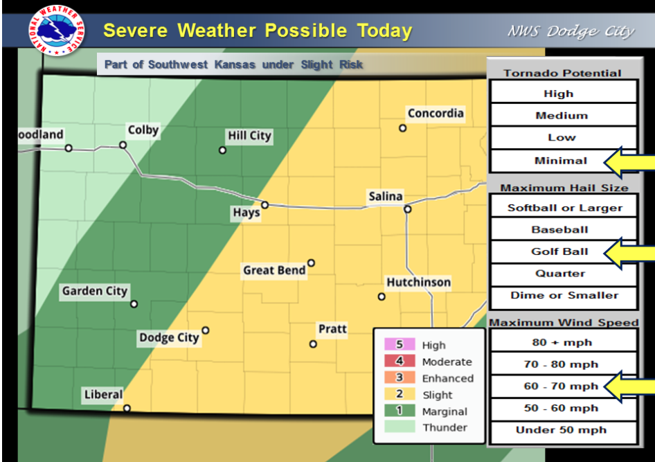
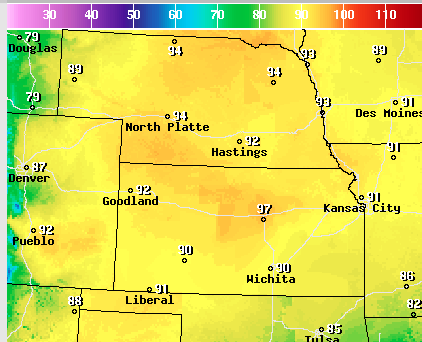
Tuesday A 20 percent chance of showers and thunderstorms. Mostly sunny, with a high near 92. Breezy, with a south wind 11 to 21 mph.

Tuesday Night A 20 percent chance of showers and thunderstorms. Partly cloudy, with a low around 66. South wind 8 to 16 mph becoming west southwest after midnight.

WednesdayA 40 percent chance of showers and thunderstorms. Partly sunny, with a high near 82. North northeast wind 8 to 16 mph.

Wednesday NightA 20 percent chance of showers and thunderstorms. Mostly cloudy, with a low around 58.

ThursdayA 20 percent chance of showers and thunderstorms. Mostly cloudy, with a high near 77.

Partly sunny Friday, chance for thunderstorms

A cold front will move across western Kansas today with a chance for severe thunderstorms. The best chance for storms will be early afternoon in the Liberal to Dodge City to Hays areas, and by mid to late afternoon in the in the Ashland to Pratt areas and east. Large hail from quarter to golf ball size, and damaging winds over 60 mph.

Today Showers and thunderstorms likely, mainly between 4pm and 5pm. Partly sunny, with a high near 85. South southeast wind 7 to 11 mph. Chance of precipitation is 60%. New rainfall amounts between a quarter and half of an inch possible.

Tonight Showers and thunderstorms likely, mainly before 10pm. Mostly cloudy, with a low around 57. North northwest wind 9 to 16 mph. Chance of precipitation is 70%. New precipitation amounts between a tenth and quarter of an inch, except higher amounts possible in thunderstorms.

SaturdayMostly cloudy, then gradually becoming sunny, with a high near 76. North northwest wind 14 to 17 mph.

Saturday NightMostly clear, with a low around 53. North wind 5 to 9 mph becoming calm in the evening.

SundaySunny, with a high near 85. West southwest wind 6 to 11 mph becoming south in the afternoon.

Sunday NightMostly clear, with a low around 62.

MondaySunny, with a high near 87. Breezy.

Sunny, hot Thursday

Screen Shot 2016-08-18 at 4.49.49 AMToday Sunny, with a high near 93. South southwest wind 6 to 16 mph.
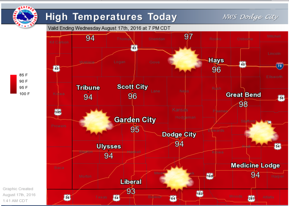
Tonight Mostly clear, with a low around 68. South southeast wind 7 to 14 mph.

FridayA 50 percent chance of showers and thunderstorms, mainly after noon. Partly sunny, with a high near 86. South wind 7 to 14 mph becoming west northwest in the afternoon.

Friday NightA 50 percent chance of showers and thunderstorms, mainly before midnight. Mostly cloudy, with a low around 60. North wind 10 to 14 mph.

SaturdayMostly sunny, with a high near 74. North wind 8 to 13 mph.

Saturday NightPartly cloudy, with a low around 54.

SundayMostly sunny, with a high near 79.

Sunday NightPartly cloudy, with a low around 60.

MondayMostly sunny, with a high near 85.

Sunny, hot Wednesday

Today Sunny, with a high near 96. South wind 6 to 13 mph.

Screen Shot 2016-08-17 at 5.29.49 AMTonight Partly cloudy, with a low around 66. South wind 8 to 14 mph.
ThursdaySunny, with a high near 92. South wind 7 to 15 mph.

Thursday NightMostly clear, with a low around 68. South southeast wind 9 to 14 mph.

FridayA 30 percent chance of showers and thunderstorms, mainly after noon. Partly sunny, with a high near 91. South wind 8 to 13 mph becoming west southwest in the afternoon.

Friday NightShowers and thunderstorms likely, mainly after 8pm. Mostly cloudy, with a low around 61. Chance of precipitation is 60%. New rainfall amounts between a quarter and half of an inch possible.

SaturdayShowers and thunderstorms likely, mainly before 8am. Mostly cloudy, with a high near 75. Chance of precipitation is 60%. New rainfall amounts of less than a tenth of an inch, except higher amounts possible in thunderstorms.

Saturday NightA 20 percent chance of showers and thunderstorms. Mostly cloudy, with a low around 54.

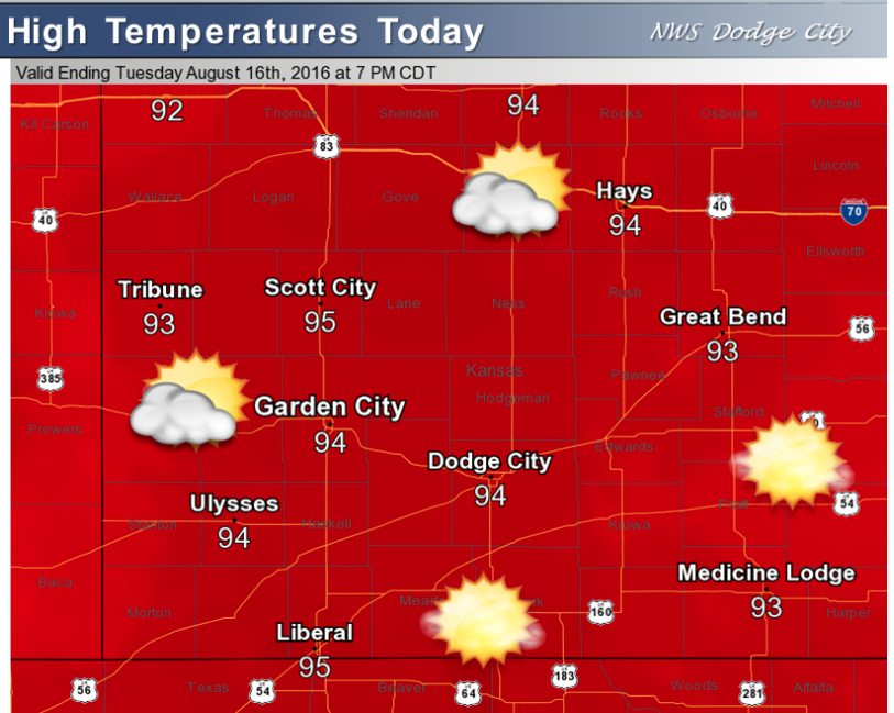
Sunny, hot Tuesday

Partly cloudy today with highs in the 90s this afternoon.

Screen Shot 2016-08-16 at 4.54.34 AMToday Mostly sunny, with a high near 94. South southwest wind 6 to 13 mph.

Tonight Partly cloudy, with a low around 64. South wind 7 to 10 mph.

WednesdaySunny, with a high near 94. South wind 6 to 14 mph.

Wednesday NightMostly clear, with a low around 66. South wind 8 to 11 mph.

ThursdaySunny, with a high near 91. South wind 7 to 15 mph.

Thursday NightA 20 percent chance of showers and thunderstorms. Partly cloudy, with a low around 68.

FridayA 40 percent chance of showers and thunderstorms. Partly sunny, with a high near 85

Sunny, hot Monday


Today Mostly sunny, with a high near 92. South wind 7 to 10 mph.

Screen Shot 2016-08-15 at 6.09.50 AMTonight Mostly clear, with a low around 64. South wind 7 to 10 mph.

TuesdaySunny, with a high near 93. South wind 7 to 10 mph.

Tuesday NightMostly clear, with a low around 64. South wind 7 to 10 mph.

WednesdaySunny, with a high near 92. South wind 6 to 9 mph.

Wednesday NightMostly clear, with a low around 66.

ThursdaySunny, with a high near 91.

Thursday NightPartly cloudy, with a low around 67.

FridayA 50 percent chance of showers and thunderstorms after 8am. Partly sunny, with a high near 85.

Copyright Eagle Radio | FCC Public Files | EEO Public File