We have a brand new updated website! Click here to check it out!

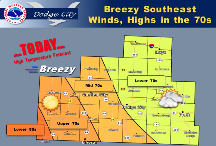
Sunny, warmer Thursday

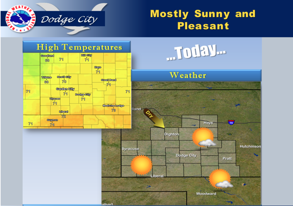
Mostly sunny skies along with high temperatures around 70 to 75 can be expected today.

Screen Shot 2016-04-21 at 5.54.53 AMToday Sunny, with a high near 71. North northwest wind 8 to 16 mph.

Tonight Clear, with a low around 42. North wind 5 to 10 mph.

FridaySunny, with a high near 76. North northeast wind 5 to 8 mph becoming south southeast in the afternoon.

Friday NightMostly clear, with a low around 51. South southeast wind 10 to 13 mph.

SaturdayMostly sunny, with a high near 82. Very windy, with a south wind 15 to 20 mph increasing to 27 to 32 mph in the afternoon.

Saturday NightA 20 percent chance of showers and thunderstorms. Partly cloudy, with a low around 56. Breezy.

SundayA 30 percent chance of showers and thunderstorms. Mostly sunny, with a high near 76.

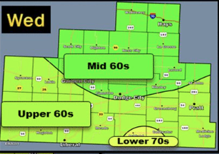
Foggy start, sunny Wednesday afternoon


Moderating temperatures are expected through Thursday.

Screen Shot 2016-04-20 at 5.51.53 AMToday Areas of fog before 10am. Otherwise, partly sunny, with a high near 65. West wind 6 to 9 mph.

Tonight A 20 percent chance of showers and thunderstorms before 10pm. Partly cloudy, with a low around 41. Calm wind becoming northwest 5 to 8 mph after midnight.

ThursdaySunny, with a high near 70. North wind 6 to 14 mph.

Thursday NightMostly clear, with a low around 43. North wind 5 to 10 mph.

FridaySunny, with a high near 75. Northwest wind around 7 mph becoming east in the afternoon.

Friday NightClear, with a low around 50.

SaturdaySunny, with a high near 80. Breezy.

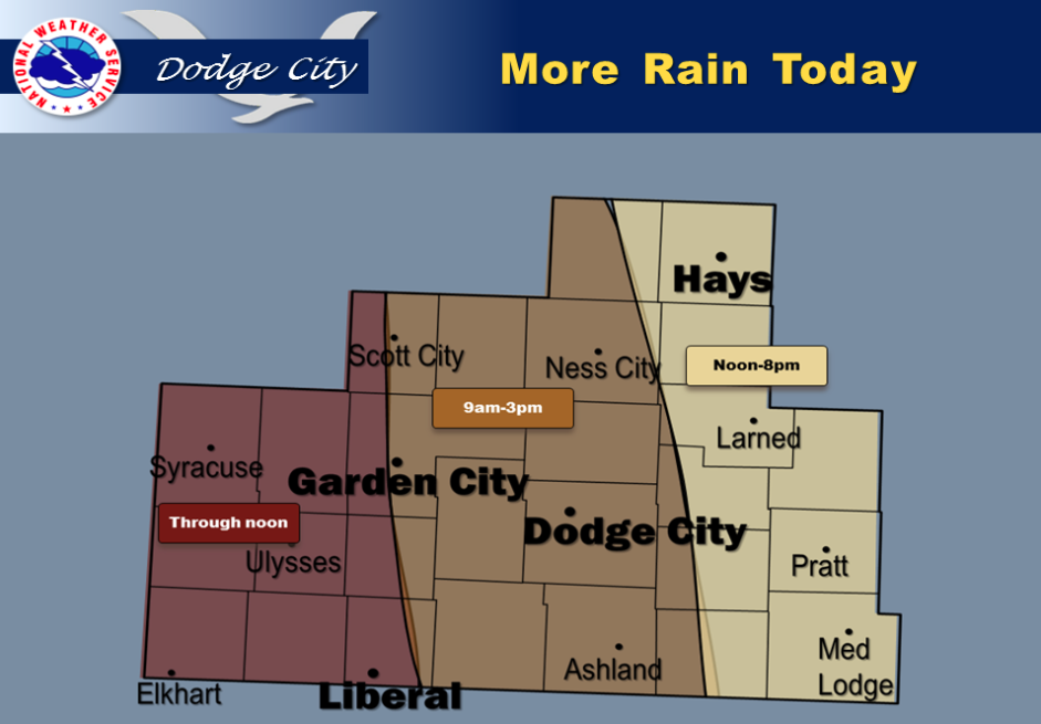
Cool, wet Tuesday


Rain showers and isolated thunderstorms will spread into the southwest, reaching the Scott City-Garden City-Liberal areas by 6 or 7 am. The bands of rain and rain showers then will continue to spread eastward through the late morning hours and early afternoon.

Rain will be continuing all afternoon in the east (Wakeeney-Hays-LaCrosse-Saint John-Coldwater-Medicine Lodge).

By mid to late afternoon the rain will probably have ended in the far west near the Colorado line. Rainfall amounts will be on the order of one quarter of an inch in most areas to as much as three quarters of an inch.

Minor showers may continue all evening following the rain, however these timeframes represent the periods of expected heaviest rainfall.

Screen Shot 2016-04-19 at 5.36.13 AMToday Showers and thunderstorms likely, then showers and possibly a thunderstorm after 4pm. High near 55. North northwest wind 5 to 8 mph becoming east northeast in the morning. Chance of precipitation is 80%. New rainfall amounts between a tenth and quarter of an inch, except higher amounts possible in thunderstorms.

Tonight Showers and thunderstorms likely, mainly before 10pm. Cloudy, with a low around 41. North wind 5 to 8 mph. Chance of precipitation is 60%. New rainfall amounts between a tenth and quarter of an inch, except higher amounts possible in thunderstorms.

WednesdayA chance of showers and thunderstorms before 3pm, then a slight chance of showers after 5pm. Mostly cloudy, with a high near 65.

West northwest wind 6 to 10 mph. Chance of precipitation is 30%.

Wednesday NightA 30 percent chance of showers and thunderstorms, mainly before 8pm. Mostly cloudy, with a low around 42. Northwest wind 7 to 10 mph.

ThursdayMostly sunny, with a high near 71. North northwest wind 8 to 14 mph.

Thursday NightMostly clear, with a low around 43.

FridaySunny, with a high near 75.
Partly cloudy, warmer Monday

Normal temperatures for mid April will be in store for the next several days as an upper low continues to move out of the Rockies region and into the Great Plains. We will experience near normal temperatures most most of the week. Today will be mostly dry outside of a few isolated morning showers. Additional rains are expected on Tuesday as the upper low moves out over Kansas. Light to moderate rainfall amounts are all that are expected with the next round of rain Tuesday, on the order of around a tenth of an inch to a quarter inch.

Screen Shot 2016-04-18 at 5.34.48 AMMonday Cloudy, then gradually becoming mostly sunny, with a high near 61. Northwest wind 11 to 16 mph.

Monday Night Partly cloudy, with a low around 41. Northwest wind around 7 mph.

Tuesday A slight chance of showers, then a chance of showers and thunderstorms after 11am. Mostly cloudy, with a high near 64. North wind around 7 mph becoming east southeast in the afternoon. Chance of precipitation is 50%.

Tuesday Night A 50 percent chance of showers and thunderstorms. Mostly cloudy, with a low around 43. Northwest wind around 7 mph.

Wednesday A 40 percent chance of showers and thunderstorms. Partly sunny, with a high near 66.

Wednesday Night Partly cloudy, with a low around 43.

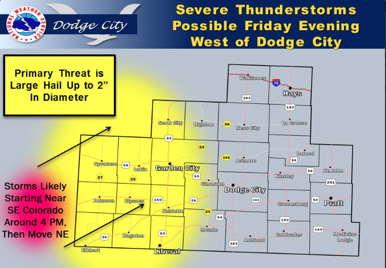
Cloudy, windy Friday with a chance for thunderstorms


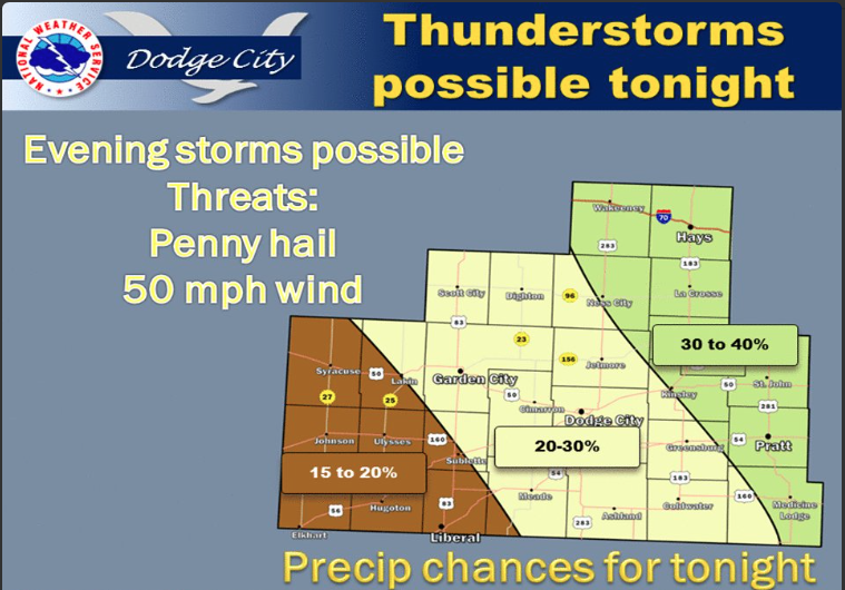
Screen Shot 2016-04-15 at 5.27.00 AMScattered thunderstorms, some severe, are possible west of Dodge City Friday afternoon and evening.

Friday A 20 percent chance of showers and thunderstorms. Cloudy, with a high near 73. Windy, with a south wind 20 to 28 mph.

Friday Night Showers and thunderstorms likely, mainly after 4am. Cloudy, with a low around 54. Very windy, with a south southeast wind 22 to 30 mph. Chance of precipitation is 60%. New rainfall amounts of less than a tenth of an inch, except higher amounts possible in thunderstorms.

SaturdayShowers and thunderstorms likely, mainly before 7am, then showers likely and possibly a thunderstorm after 9am. Cloudy, with a high near 66. Breezy, with a south southeast wind 18 to 23 mph, with gusts as high as 36 mph. Chance of precipitation is 60%. New rainfall amounts between a quarter and half of an inch possible.

Saturday NightShowers and possibly a thunderstorm. Low around 52. Windy, with a southeast wind 21 to 26 mph decreasing to 15 to 20 mph after midnight. Chance of precipitation is 90%. New rainfall amounts between three quarters and one inch possible.

SundayRain and possibly a thunderstorm. High near 62. Breezy. Chance of precipitation is 90%. New rainfall amounts between 1 and 2 inches possible.

Sunday NightRain and possibly a thunderstorm before 8pm, then showers likely and possibly a thunderstorm after 8pm. Low around 45. Chance of precipitation is 80%. New rainfall amounts between a half and three quarters of an inch possible.

MondayA 50 percent chance of showers and thunderstorms. Mostly cloudy, with a high near 63.

Sunny, windy Thursday

A stiff south-southeast breeze will develop by afternoon, helping temps warm into the 70s once the clouds move away.

Screen Shot 2016-04-14 at 5.19.11 AMToday Patchy fog between 9am and 10am. Otherwise, sunny, with a high near 73. Breezy, with a south southeast wind 8 to 13 mph increasing to 16 to 21 mph in the afternoon.

Tonight A 20 percent chance of showers and thunderstorms after 1am. Increasing clouds, with a low around 53. Breezy, with a south southeast wind 17 to 21 mph.

FridayA 20 percent chance of showers and thunderstorms after 9am. Mostly cloudy, with a high near 75. Windy, with a south southeast wind 20 to 28 mph.

Friday NightA 50 percent chance of showers and thunderstorms. Mostly cloudy, with a low around 54. Windy, with a south southeast wind 21 to 26 mph, with gusts as high as 36 mph.

SaturdayA chance of showers and thunderstorms, then showers likely and possibly a thunderstorm after 8am. Cloudy, with a high near 67. Breezy, with a southeast wind 17 to 20 mph. Chance of precipitation is 60%. New rainfall amounts between a tenth and quarter of an inch, except higher amounts possible in thunderstorms.

Saturday NightShowers likely and possibly a thunderstorm. Cloudy, with a low around 50. Breezy. Chance of precipitation is 70%. New rainfall amounts between a quarter and half of an inch possible.

SundayShowers and possibly a thunderstorm. High near 63. Chance of precipitation is 90%. New rainfall amounts between three quarters and one inch possible.

Sunny, warmer Wednesday

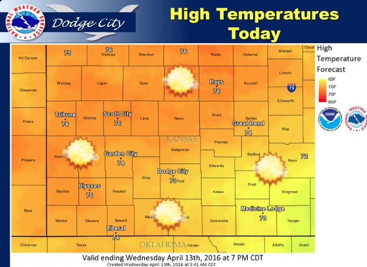
Mostly sunny today with highs in the 70s this afternoon.

Screen Shot 2016-04-13 at 5.52.02 AMToday Sunny, with a high near 77. South wind 6 to 14 mph.

Tonight Partly cloudy, with a low around 49. South southeast wind 7 to 14 mph.

ThursdayPatchy fog before 9am. Otherwise, mostly sunny, with a high near 76. Breezy, with a south wind 7 to 12 mph increasing to 15 to 20 mph in the afternoon.

Thursday NightA 20 percent chance of showers and thunderstorms after midnight. Mostly cloudy, with a low around 54. Breezy, with a south southeast wind 18 to 21 mph.

FridayA 40 percent chance of showers and thunderstorms, mainly after 8am. Mostly cloudy, with a high near 73. Windy, with a south southeast wind 20 to 26 mph, with gusts as high as 36 mph.

Friday NightA 50 percent chance of showers and thunderstorms. Mostly cloudy, with a low around 55. Windy.

SaturdayA 50 percent chance of showers and thunderstorms. Cloudy, with a high near 66. Breezy.

Saturday NightShowers likely and possibly a thunderstorm. Cloudy, with a low around 50. Breezy. Chance of precipitation is 70%. New rainfall amounts between a half and three quarters of an inch possible.

SundayShowers likely and possibly a thunderstorm. Cloudy, with a high near 64. Chance of precipitation is 70%. New rainfall amounts between a quarter and half of an inch possible.

Sunny, warmer Tuesday

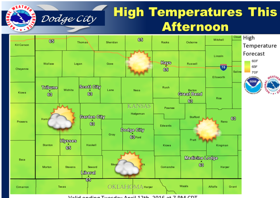
Mostly sunny today with highs up into the 60s this afternoon.

Screen Shot 2016-04-12 at 5.55.23 AMToday Areas of frost before 9am. Otherwise, sunny, with a high near 65. South wind 5 to 10 mph increasing to 11 to 16 mph in the afternoon.

Tonight Clear, with a low around 37. South wind 7 to 15 mph.

Wednesday Sunny, with a high near 75. South wind 5 to 14 mph.

Wednesday Night Mostly clear, with a low around 49. South southeast wind 9 to 13 mph.

ThursdayMostly sunny, with a high near 77.

Thursday NightA 30 percent chance of showers and thunderstorms, mainly between 2am and 3am. Mostly cloudy, with a low around 55. Breezy.

FridayA 40 percent chance of showers and thunderstorms, mainly after 7am. Mostly cloudy, with a high near 72. Windy.

Friday NightShowers likely and possibly a thunderstorm. Cloudy, with a low around 52. Breezy. Chance of precipitation is 60%. New rainfall amounts between a tenth and quarter of an inch, except higher amounts possible in thunderstorms.

Partly sunny, chance of showers

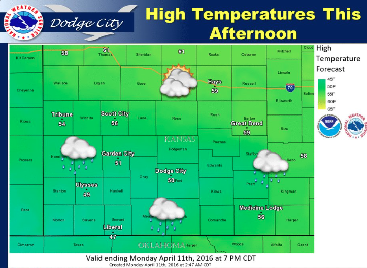
Mostly cloudy today with lingering rain showers. Highs generally in the upper 40s and 50s this afternoon.

Tonight Mostly clear, with a low around 31. East northeast wind 5 to 10 mph becoming light and variable after midnight.

TuesdayAreas of frost before 10am. Otherwise, sunny, with a high near 66. South wind 5 to 15 mph.

Tuesday NightMostly clear, with a low around 38. South southeast wind 8 to 16 mph.

WednesdaySunny, with a high near 75. South wind 7 to 13 mph.

Wednesday NightMostly clear, with a low around 47.

ThursdaySunny, with a high near 77. Breezy.

Thursday NightA 20 percent chance of showers and thunderstorms after 8pm. Partly cloudy, with a low around 53. Breezy.

Sunny, mild Friday


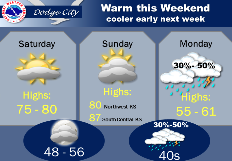
Warm and dry conditions can be expected through Sunday afternoon. Rain showers and thunderstorms will then be possible across all of western Kansas Sunday night and Monday.

Screen Shot 2016-04-08 at 6.04.41 AMToday Mostly sunny, with a high near 73. West southwest wind 5 to 8 mph.

Tonight Partly cloudy, with a low around 40. Southwest wind 6 to 10 mph becoming east southeast after midnight.

SaturdayMostly sunny, with a high near 75. Breezy, with an east southeast wind 10 to 20 mph.

Saturday NightPartly cloudy, with a low around 50. Breezy, with a south wind 15 to 20 mph.

SundaySunny, with a high near 80. Southwest wind 11 to 15 mph becoming northwest in the afternoon.

Sunday NightA 40 percent chance of showers and thunderstorms after 8pm. Mostly cloudy, with a low around 43.

MondayA 40 percent chance of showers and thunderstorms. Mostly cloudy, with a high near 60.

Sunny, breezy Thursday


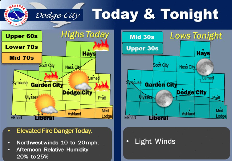
Mostly Sunny and warm today. Elevated Fire Danger levels expected this afternoon

Screen Shot 2016-04-07 at 5.47.47 AMToday Mostly sunny, with a high near 68. Breezy, with a north northwest wind 9 to 14 mph increasing to 19 to 24 mph in the afternoon.

Tonight Mostly clear, with a low around 36. Breezy, with a north wind 16 to 21 mph decreasing to 5 to 10 mph after midnight.

FridaySunny, with a high near 72. West northwest wind 7 to 13 mph.

Friday NightMostly clear, with a low around 39. North northeast wind 8 to 10 mph becoming east southeast after midnight.

SaturdayMostly sunny, with a high near 71. Breezy, with a south southeast wind 11 to 20 mph.

Saturday NightPartly cloudy, with a low around 50.

SundaySunny, with a high near 78.

Sunday NightA 50 percent chance of showers and thunderstorms. Mostly cloudy, with a low around 44.

MondayA 30 percent chance of showers and thunderstorms. Partly sunny, with a high near 62.

Sunny, windy Wednesday


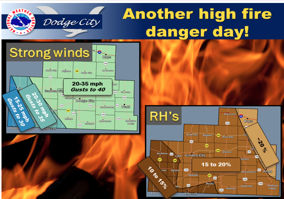
Screen Shot 2016-04-06 at 5.46.36 AMAnother day of high fire danger is expected today with strong northwesterly winds and low relative humidities.

Today Sunny, with a high near 70. Very windy, with a north northwest wind 18 to 23 mph increasing to 26 to 31 mph in the morning. Winds could gust as high as 41 mph.

Tonight Mostly clear, with a low around 42. West wind 7 to 17 mph.

ThursdayMostly sunny, with a high near 71. Breezy, with a north northwest wind 9 to 14 mph increasing to 17 to 22 mph in the afternoon.

Thursday NightClear, with a low around 35. North wind 13 to 18 mph decreasing to 5 to 10 mph after midnight. Winds could gust as high as 28 mph.

FridaySunny, with a high near 73. West wind 7 to 11 mph.

Friday NightMostly clear, with a low around 39.

SaturdaySunny, with a high near 70.

Warm, windy and a chance for thunderstorms


Today will be very warm with a high fire danger. Afternoon relative humidities will fall to low levels. A red flag warning is in effect.

Screen Shot 2016-04-05 at 6.17.02 AM
Toda
y A 30 percent chance of showers and thunderstorms, mainly after 5pm. Partly sunny, with a high near 80. South southeast wind 13 to 17 mph becoming west northwest in the afternoon. Winds could gust as high as 29 mph.

Tonight A 30 percent chance of showers and thunderstorms, mainly before 8pm. Mostly cloudy, then gradually becoming mostly clear, with a low around 44. Breezy, with a north northwest wind 16 to 24 mph.

Wednesday Sunny, with a high near 67. Very windy, with a north northwest wind 18 to 23 mph increasing to 26 to 31 mph in the morning. Winds could gust as high as 41 mph.

Wednesday NightMostly clear, with a low around 43. North northwest wind 13 to 18 mph becoming west 7 to 12 mph after midnight. Winds could gust as high as 28 mph.

ThursdaySunny, with a high near 72. Breezy, with a north northwest wind 11 to 16 mph increasing to 17 to 22 mph in the afternoon.

Thursday NightMostly clear, with a low around 37. Breezy.

FridaySunny, with a high near 70.

Copyright Eagle Radio | FCC Public Files | EEO Public File