We have a brand new updated website! Click here to check it out!

Sunny, cooler Monday


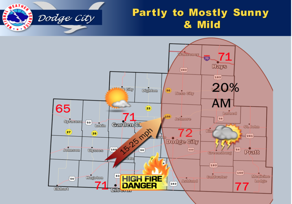
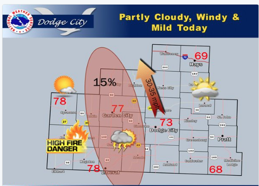
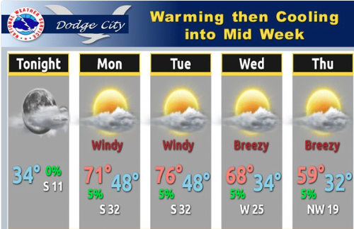
Today will still be warm into Tuesday. A cold front will move into western Kansas late Tuesday afternoon and evening with isolated thunderstorms possible. Severe weather threat looks low. Ahead of the front critical fire weather conditions are forecast with a Fire Weather Watch on Tuesday afternoon from Syracuse to Jetmore and St. John and south. High Fire Danger is forecast again on Wednesday and Thursday.

Screen Shot 2016-04-04 at 6.05.12 AMToday Sunny, with a high near 72. North wind 7 to 10 mph becoming east southeast in the afternoon.

Tonight Partly cloudy, with a low around 49. South southeast wind 11 to 16 mph.

TuesdayA 20 percent chance of showers and thunderstorms after 11am. Partly sunny, with a high near 79. Breezy, with a south wind 16 to 20 mph becoming west southwest in the afternoon.

Tuesday NightA 30 percent chance of showers and thunderstorms, mainly before 10pm. Mostly cloudy, with a low around 44. Breezy, with a northwest wind 21 to 24 mph.

WednesdaySunny, with a high near 65. Very windy, with a north northwest wind 22 to 30 mph.

Wednesday NightMostly clear, with a low around 41. Breezy.

ThursdaySunny, with a high near 71. Breezy.

Thursday NightMostly clear, with a low around 38. Breezy.

FridaySunny, with a high near 70.
Sunny, breezy Friday

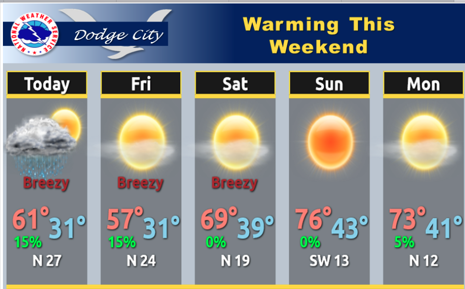
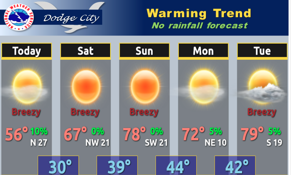
Today Sunny, with a high near 53. Breezy, with a north northwest wind 11 to 21 mph, with gusts as high as 32 mph.

Screen Shot 2016-04-01 at 5.57.36 AMTonight Mostly clear, with a low around 31. Blustery, with a west wind 15 to 20 mph decreasing to 6 to 11 mph after midnight.

SaturdaySunny, with a high near 68. North northwest wind 11 to 15 mph.

Saturday NightClear, with a low around 40. West northwest wind around 8 mph becoming south after midnight.

SundaySunny, with a high near 78. West wind 9 to 15 mph.

Sunday NightMostly clear, with a low around 44.

MondaySunny, with a high near 71.

Monday NightMostly clear, with a low around 44.

Partly sunny, cooler Thursday


A secondary shot of cooler air will move into western Kansas this afternoon with a few sprinkles or light showers possible. Then a warming trend moves across the Central Plains for the Weekend.

Screen Shot 2016-03-31 at 5.46.20 AMToday Partly sunny, with a high near 60.   Scattered sprinkles are possible after 2p.m. and breezy, with a northwest wind 13 to 22 mph.

Tonight Scattered sprinkles before 10pm. Partly cloudy, with a low around 31. Blustery, with a northwest wind 13 to 23 mph.

FridaySunny, with a high near 55. Breezy, with a north northwest wind 14 to 20 mph.

Friday NightMostly clear, with a low around 32. North northwest wind 8 to 16 mph becoming west after midnight.

SaturdaySunny, with a high near 67. North northwest wind 11 to 15 mph.

Saturday NightClear, with a low around 40.

SundaySunny, with a high near 78.

Sunday NightMostly clear, with a low around 44.

MondaySunny, with a high near 68.;

Mild, windy Wednesday

Today  Cloudy through mid morning, then gradual clearing, with a high near 71. Breezy, with a west southwest wind 16 to 23 mph. Chance of Screen Shot 2016-03-30 at 5.20.16 AMprecipitation is 10%.

Tonight A slight chance of showers before midnight, then a slight chance of showers after 1am. Mostly cloudy, with a low around 39. Windy, with a northwest wind 23 to 25 mph. Chance of precipitation is 20%.

ThursdayP artly sunny, with a high near 58. Breezy, with a northwest wind 20 to 24 mph.

Thursday Night Partly cloudy, with a low around 31. Blustery, with a north northwest wind 19 to 24 mph decreasing to 11 to 16 mph after midnight.

Friday Sunny, with a high near 56. Breezy.

Friday Night Mostly clear, with a low around 33.

Saturday Sunny, with a high near 67.


Warmer, windy Tuesday


Screen Shot 2016-03-29 at 5.51.17 AMToday  Partly sunny, with a high near 69. Very windy, with a south wind 18 to 23 mph increasing to 26 to 31 mph in the afternoon.

Tonight A 20 percent chance of showers and thunderstorms. Mostly cloudy, with a low around 55. Very windy, with a south southeast wind 23 to 30 mph.

WednesdayMostly cloudy, then gradually becoming sunny, with a high near 68. Breezy, with a west southwest wind 16 to 24 mph.

Wednesday NightA 20 percent chance of showers and thunderstorms before 9pm. Partly cloudy, with a low around 36. Breezy, with a northwest wind around 24 mph.

ThursdayMostly sunny, with a high near 58. Breezy.

Thursday NightPartly cloudy, with a low around 31. Blustery.

FridaySunny, with a high near 56.

Sunny, warmer Monday

Look for a warming trend into Tuesday, then turning cooler. Rain chances are very low.
Screen Shot 2016-03-28 at 5.20.13 AMToday Sunny, with a high near 70. Breezy, with a south wind 7 to 12 mph increasing to 19 to 24 mph in the afternoon.
Tonight A 30 percent chance of showers and thunderstorms after 1am. Mostly cloudy, with a low around 44. South southeast wind 13 to 17 mph.

TuesdayPartly sunny, with a high near 71. Very windy, with a south southeast wind 15 to 20 mph increasing to 25 to 30 mph in the afternoon.

Tuesday NightA slight chance of showers and thunderstorms between midnight and 3am. Mostly cloudy, with a low around 54. Breezy, with a south southeast wind 18 to 24 mph. Chance of precipitation is 20%.

WednesdayMostly sunny, with a high near 68. Breezy, with a southwest wind 13 to 23 mph.

Wednesday NightPartly cloudy, with a low around 34.

Partly sunny, windy Friday


Screen Shot 2016-03-25 at 5.00.48 AMToday Partly sunny, with a high near 65. South wind 7 to 12 mph increasing to 13 to 18 mph in the afternoon.

Tonight A slight chance of rain between 9pm and 4am. Mostly cloudy, with a low around 34. North northwest wind 8 to 10 mph. Chance of precipitation is 20%.

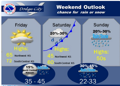
SaturdayMostly cloudy, with a high near 51. Breezy, with a north wind 13 to 21 mph.

Saturday NightA slight chance of rain and snow between 10pm and 1am, then a chance of snow. Mostly cloudy, with a low around 28. North wind 8 to 16 mph. Chance of precipitation is 30%.

SundayMostly sunny, with a high near 59. North northwest wind around 10 mph becoming west in the afternoon.

Sunday NightClear, with a low around 33.

MondaySunny, with a high near 69. Breezy.

Sunny, windy Thursday


Today Sunny, with a high near 51. Windy, with a north northwest wind 20 to 25 mph decreasing to 13 to 18 mph in the afternoon.

Screen Shot 2016-03-24 at 5.42.16 AMTonight Increasing clouds, with a low around 30. North northwest wind around 8 mph becoming south southeast after midnight.

FridayPartly sunny, with a high near 66. South wind 10 to 16 mph.

Friday NightA 20 percent chance of rain after 8pm. Mostly cloudy, with a low around 35. North wind 8 to 10 mph.

SaturdayA 30 percent chance of rain, mainly after 10am. Mostly cloudy, with a high near 52. Breezy, with a north wind 13 to 21 mph.

Saturday NightA chance of rain before 8pm, then a chance of snow. Mostly cloudy, with a low around 27. Chance of precipitation is 40%.

SundaySunny, with a high near 56.

Windy Wednesday, chance for afternoon thunderstorms


Today A 30 percent chance of rain and thunderstorms, mainly after 3pm. Increasing clouds, with a high near 63. Windy, with a southwest wind 8 to 13 mph becoming west northwest 20 to 25 mph in the afternoon.

Screen Shot 2016-03-23 at 5.47.08 AMTonight A chance of rain and snow, mainly before midnight. Cloudy, then gradually becoming partly cloudy, with a low around 28. Very windy, with a north northwest wind 33 to 38 mph decreasing to 21 to 26 mph after midnight. Winds could gust as high as 55 mph. Chance of precipitation is 50%. New snow accumulation of less than a half inch possible.

Thursday Sunny, with a high near 53. Northwest wind 7 to 16 mph.

Thursday Night Mostly clear, with a low around 31. South wind 7 to 10 mph.

FridayMostly sunny, with a high near 66. South wind 11 to 14 mph becoming west northwest in the afternoon.

Friday NightA slight chance of rain and snow after 11pm. Mostly cloudy, with a low around 37. Chance of precipitation is 20%.

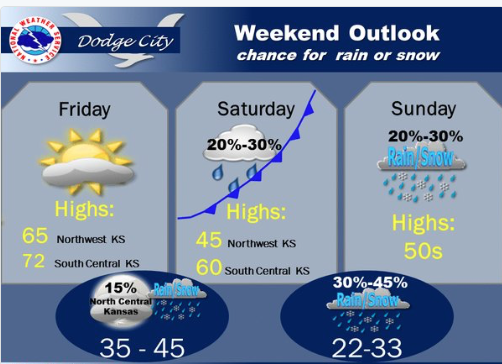
SaturdayA chance of rain and snow. Mostly cloudy, with a high near 49. Breezy. Chance of precipitation is 30%.

Saturday NightA chance of rain and snow. Mostly cloudy, with a low around 27. Chance of precipitation is 30%.

Sunny, warmer Tuesday


Today Mostly sunny, with a high near 88. Breezy, with a west southwest wind 6 to 11 mph increasing to 15 to 20 mph in the afternoon.

Tonight Partly cloudy, with a low around 45. South southwest wind 9 to 14 mph.

WednesdayA 40 percent chance of rain, mainly after 1pm. Increasing clouds, with a high near 55. Very windy, with a west southwest wind 11 to 21 mph becoming north northwest 27 to 37 mph. Winds could gust as high as 55 mph.

Wednesday NightA chance of rain, mixing with snow after 8pm, then gradually ending. Cloudy, then gradually becoming partly cloudy, with a low around 28. Very windy, with a north northwest wind 31 to 36 mph decreasing to 18 to 23 mph after midnight. Winds could gust as high as 55 mph. Chance of precipitation is 40%.

ThursdaySunny, with a high near 52. Northwest wind 7 to 14 mph.

Thursday NightMostly clear, with a low around 32.

FridayMostly sunny, with a high near 66.

Friday NightA 20 percent chance of rain. Mostly cloudy, with a low around 37.

Sunny, warmer Monday

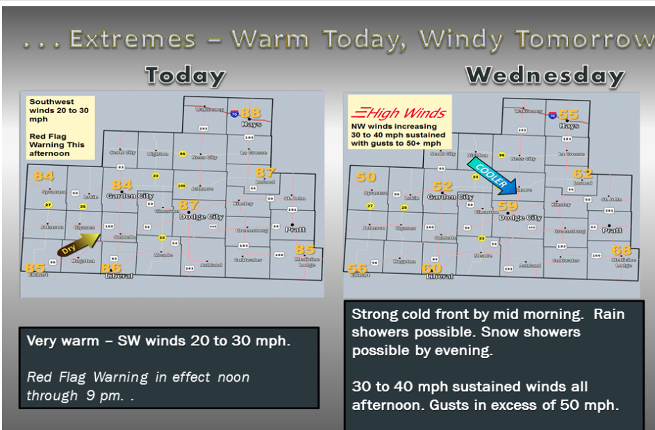
Much warmer this afternoon, and not as cold tonight. The warming trend will continue into Tuesday afternoon when highs soar into the upper 80s. Critical fire weather conditions are likely on Tuesday afternoon and a Fire weather watch is in effect for Tuesday. A dramatic cooldown is expected Wednesday as a cold front sweeps through the area with 30 to 40 mph winds, bringing a chance for rain and even snow Wednesday night.

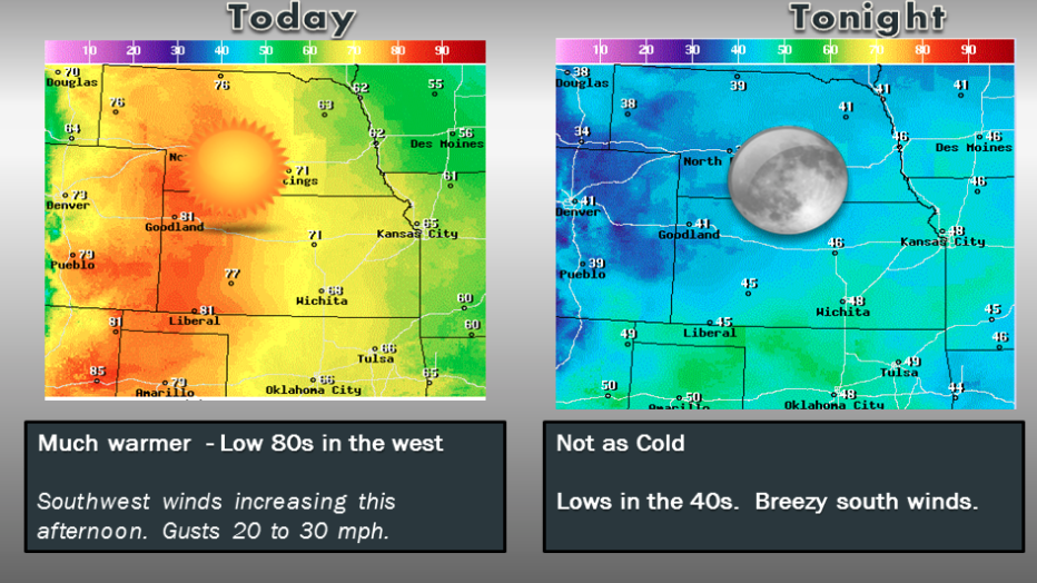
Today Sunny, with a high near 75. South southwest wind 9 to 17 mph.

Tonight Partly cloudy, with a low around 42. South wind 9 to 13 mph.

TuesdayMostly sunny, with a high near 84. West wind 7 to 17 mph.

Tuesday NightPartly cloudy, with a low around 46. Southwest wind 9 to 16 mph.

WednesdayA 50 percent chance of rain, mainly after 10am. Partly sunny, with a high near 56. Very windy, with a north northwest wind 15 to 20 mph increasing to 29 to 34 mph in the afternoon. Winds could gust as high as 46 mph.

Wednesday NightA chance of rain and snow, mainly before 2am. Mostly cloudy, with a low around 28. Very windy. Chance of precipitation is 40%.

ThursdaySunny, with a high near 52.

Cold, wet Friday

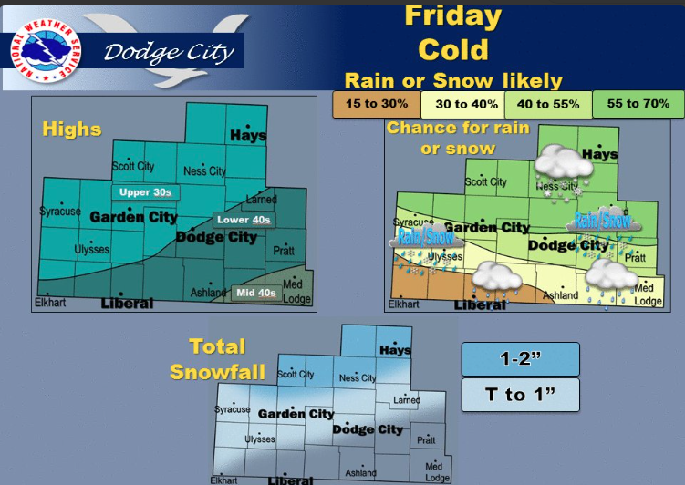
It will be cloudy and cold on Friday. Total snow accumulations of 1 to 2 inches possible across north central Kansas.

Screen Shot 2016-03-18 at 5.03.23 AM

Today Snow before 2pm, then a slight chance of rain and snow. High near 40. North northeast wind 11 to 15 mph. Chance of precipitation is 90%. Total daytime snow accumulation of less than one inch possible.

Tonight Mostly clear, with a low around 22. North northwest wind 6 to 11 mph.
Saturday Mostly sunny, with a high near 47. North northwest wind 6 to 11 mph increasing to 12 to 17 mph in the afternoon.

Saturday Night Mostly clear, with a low around 21. North northwest wind 7 to 15 mph.

Sunday Sunny, with a high near 53. Northwest wind 8 to 10 mph.

Sunday Night Clear, with a low around 31.

Monday Sunny, with a high near 73.

Sunny, windy Thursday


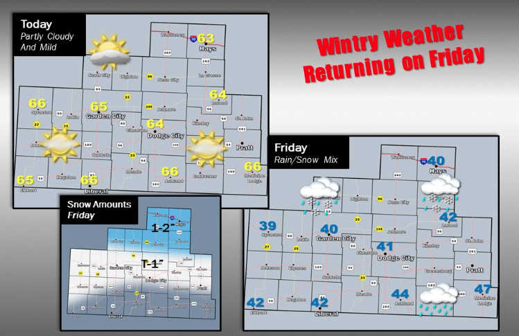
A cool down, along with a rain, snow mix, is headed for parts of central and southwest Kansas on Friday.

Today Mostly sunny, with a high near 63. Light west wind becoming west southwest 6 to 11 mph in the morning. Winds could gust as high as 21 mph.

Tonight tRain showers likely after 9pm, mixing with snow after 2am. Cloudy, with a low around 33. Northeast wind 9 to 13 mph. Chance of precipitation is 60%. New snow accumulation of less than one inch possible.

FridaySnow likely, mainly before 11am. Cloudy, with a high near 40. North northeast wind 11 to 18 mph, with gusts as high as 28 mph. Chance of precipitation is 60%. New snow accumulation of around an inch possible.

Friday NightMostly cloudy, with a low around 25. North wind 7 to 13 mph.

SaturdayMostly sunny, with a high near 48. North northwest wind 7 to 16 mph.

Saturday NightMostly clear, with a low around 23.

SundaySunny, with a high near 57.

Sunday NightMostly clear, with a low around 32.

Copyright Eagle Radio | FCC Public Files | EEO Public File