We have a brand new updated website! Click here to check it out!

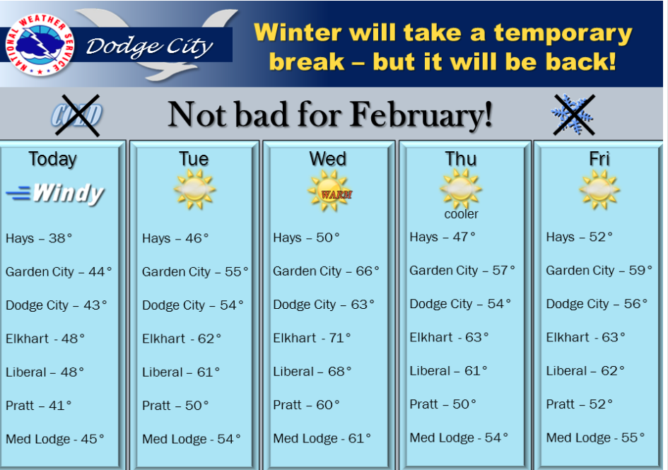
Sunny, very windy Monday


It will be very windy again today with cool temperatures. But, better weather is in store for the remainder of the week! This might be a great week for outdoor activities.

Screen Shot 2016-02-08 at 5.51.15 AMToday Sunny, with a high near 39. Very windy, with a north northwest wind 22 to 32 mph, with gusts as high as 43 mph.

Tonight Partly cloudy, with a low around 24. Northwest wind 9 to 17 mph.

Tuesday Mostly cloudy, with a high near 47. Northwest wind 9 to 16 mph.

Tuesday NightMostly cloudy, with a low around 25. North northwest wind 5 to 10 mph becoming light north northeast after midnight.

WednesdaySunny, with a high near 51. Light and variable wind becoming south southwest 5 to 10 mph in the morning.

Wednesday NightMostly clear, with a low around 26.

ThursdaySunny, with a high near 48.

Thursday NightPartly cloudy, with a low around 28.
Cloudy, cold Friday


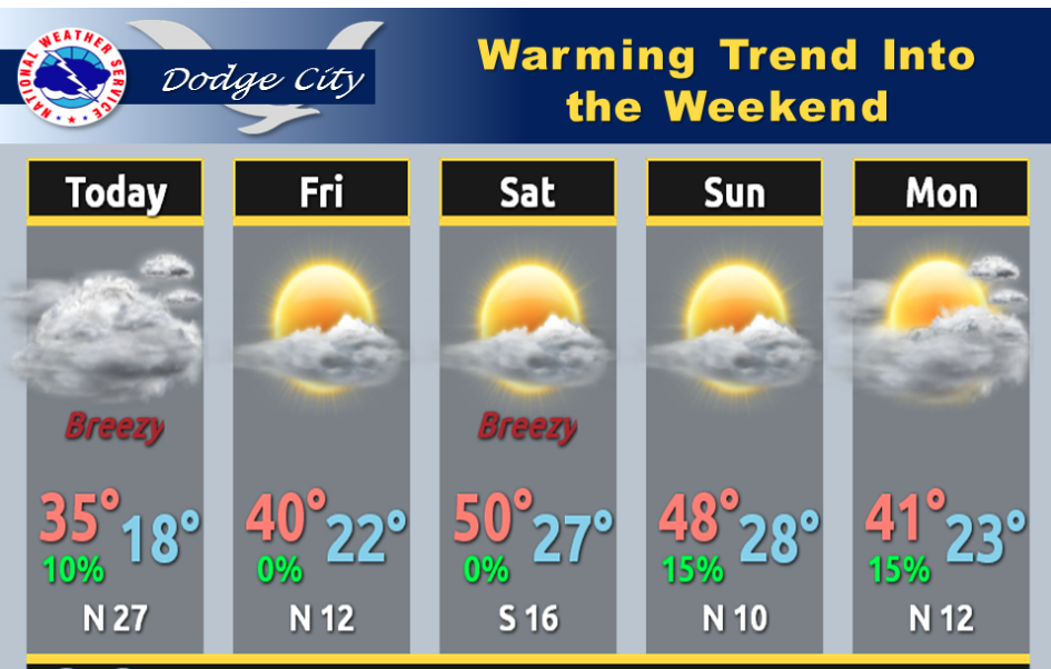
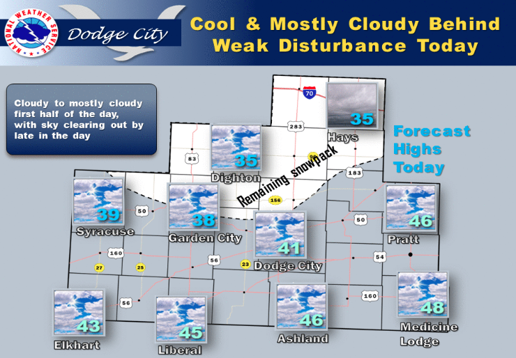
Weak upper disturbance this morning will not produce any measurable precip. Highs today mid 30s to upper 40s

Screen Shot 2016-02-05 at 5.27.20 AMToday Cloudy, with a high near 35. Calm wind becoming west 5 to 9 mph in the morning.

Tonight Partly cloudy, with a low around 17. Northwest wind around 9 mph.

SaturdaySunny, with a high near 41. West southwest wind around 9 mph.

Saturday NightMostly clear, with a low around 28. Southwest wind 9 to 13 mph becoming northwest after midnight.

SundayMostly sunny, with a high near 42. Windy, with a northwest wind 14 to 19 mph increasing to 21 to 26 mph in the afternoon. Winds could gust as high as 36 mph.

Sunday NightMostly clear, with a low around 24. Blustery.

MondaySunny, with a high near 39. Windy.

Sunny, warmer Thursday


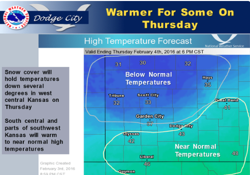
Snow covered areas of western Kansas will have trouble warming much above the freezing mark on Thursday.

Screen Shot 2016-02-04 at 5.26.49 AMToday Sunny, with a high near 35. West wind 7 to 14 mph.

Tonight Increasing clouds, with a low around 15. West southwest wind around 6 mph becoming calm in the evening.

FridayMostly cloudy, with a high near 37. Calm wind becoming northwest 5 to 8 mph in the morning.

Friday NightPartly cloudy, with a low around 19. Northwest wind around 9 mph.

SaturdaySunny, with a high near 41. West northwest wind around 9 mph becoming southwest in the afternoon.

Saturday NightPartly cloudy, with a low around 27.

SundayMostly sunny, with a high near 43. Breezy.

Sunday NightMostly clear, with a low around 25. Blustery.

MondaySunny, with a high near 41. Breezy.

Partly cloudy, warmer Wednesday

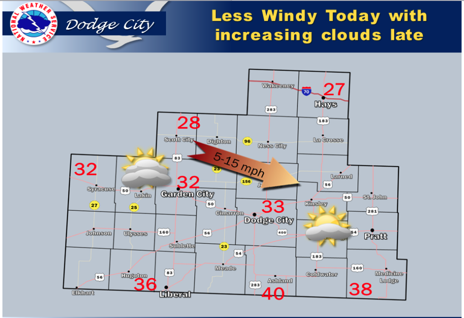
It will be less windy today with increasing cloudiness in the late afternoon. Temperatures over the snow covered areas from Scott City to Hays will stay colder, with warmer afternoon readings in the counties that border Oklahoma.

Screen Shot 2016-02-03 at 5.44.46 AMToday Increasing clouds, with a high near 28. Northwest wind 8 to 13 mph.

Tonight Mostly clear, with a low around 10. Wind chill values as low as -1. West wind around 8 mph.

ThursdaySunny, with a high near 35. Wind chill values as low as -2. West wind 8 to 13 mph.

Thursday NightPartly cloudy, with a low around 16. West wind around 6 mph becoming calm in the evening.

FridayMostly cloudy, with a high near 38. Light west wind becoming northwest 5 to 10 mph in the morning.

Friday NightPartly cloudy, with a low around 18.

SaturdaySunny, with a high near 41.

Saturday NightMostly clear, with a low around 25.

SundayMostly sunny, with a high near 41.

Cold, snowy Tuesday


Light snow will persist today in parts of central and western Kansas and gradually taper off this afternoon. Roads will be snow packed and hazardous. Winds will increase from the north at 25 to 35 mph with gusts to 40 mph today, resulting in blowing and drifting of snow. Farther south, only a flurry or two can be expected.

Today Snow, mainly before 1pm. Areas of blowing snow between 10am and 3pm. High near 33. Very windy, with a north northwest wind 17 to 22 mph increasing to 25 to 30 mph in the afternoon. Chance of precipitation is 90%. New snow accumulation of 2 to 4 inches possible.

Screen Shot 2016-02-02 at 5.33.15 AMTonight Mostly cloudy, with a low around 16. Wind chill values as low as 1. Windy, with a north northwest wind 23 to 28 mph decreasing to 17 to 22 mph after midnight.

Wednesday Mostly sunny, with a high near 30. Wind chill values as low as 1. Northwest wind 8 to 16 mph.

Wednesday NightMostly clear, with a low around 8. West northwest wind 8 to 10 mph.

ThursdaySunny, with a high near 35.

Thursday NightPartly cloudy, with a low around 16.

FridayPartly sunny, with a high near 38.

Cold, wet Monday


Today Rain likely, mainly after 5pm. Cloudy, with a high near 45. Breezy, with an east wind 6 to 11 mph increasing to 18 to 23 mph in the afternoon. Chance of precipitation is 60%. New precipitation amounts between a tenth and quarter of an inch possible.

Tonight Rain before 7pm, then rain and snow between 7pm and 9pm, then snow after 9pm. The snow could be heavy at times. Areas of blowing snow after 11pm. Low around 28. Breezy, with an east wind 20 to 23 mph becoming north after midnight. Chance of precipitation is 90%. New snow accumulation of 3 to 7 inches possible.


Screen Shot 2016-02-01 at 5.21.59 AMTuesday Snow likely, mainly before 10am. Areas of blowing snow. Cloudy, with a high near 30. Very windy, with a north northwest wind 23 to 30 mph. Chance of precipitation is 60%. New snow accumulation of 1 to 2 inches possible.

Tuesday Night Cloudy, then gradually becoming partly cloudy, with a low around 13. Wind chill values as low as -1. Blustery, with a northwest wind 14 to 23 mph.

WednesdayMostly sunny, with a high near 30. Northwest wind 9 to 13 mph.

Wednesday NightMostly clear, with a low around 13.

ThursdaySunny, with a high near 38.

Sunny, windy Friday


Today Sunny, with a high near 63. Southwest wind 6 to 11 mph becoming north northwest 13 to 18 mph in the afternoon. Winds could gust as high as 28 mph.
Screen Shot 2016-01-29 at 4.56.05 AMTonight Mostly clear, with a low around 29. Northwest wind 5 to 7 mph becoming southwest after midnight.

SaturdayMostly sunny, with a high near 59. Light southwest wind becoming south 10 to 15 mph in the morning.

Saturday NightPartly cloudy, with a low around 31. Blustery, with a light and variable wind becoming north 15 to 20 mph after midnight.

SundayPartly sunny, with a high near 49. Northwest wind 7 to 17 mph.

Sunday NightA 30 percent chance of snow after midnight. Mostly cloudy, with a low around 30.

MondayA 50 percent chance of snow. Cloudy, with a high near 37. Breezy.

Monday NightSnow likely. Cloudy, with a low around 25. Very windy. Chance of precipitation is 70%.

TuesdayA 50 percent chance of snow. Cloudy, with a high near 30. Very windy.

Sunny, warmer Thursday


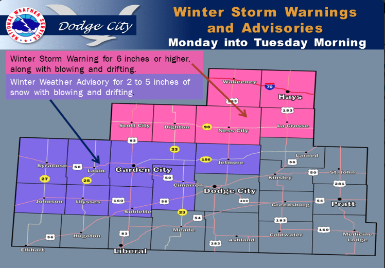
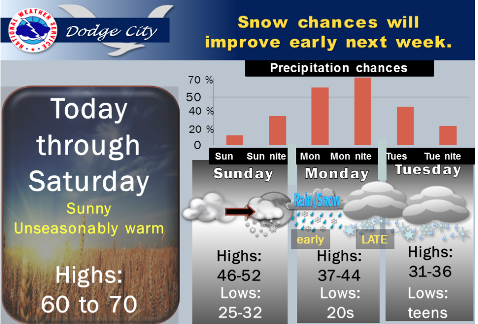
A cold front Saturday night will bring the next shot of colder air to western Kansas. There will also be a chance for snow from Sunday night through late Tuesday. At this time it appears that the best chance for measurable snowfall will be Monday and Monday night with significant snow accumulations possible across portions of western Kansas. Given the uncertainty of the track of this next winter storm system it is still too early to tell how much snow will fall in western Kansas.

Screen Shot 2016-01-28 at 5.43.47 AMToday Sunny, with a high near 60. West northwest wind 5 to 14 mph becoming south southwest in the afternoon.

Tonight Mostly clear, with a low around 29. South southwest wind 3 to 6 mph.

FridaySunny, with a high near 63. Light and variable wind becoming north northwest 5 to 10 mph in the afternoon.

Friday NightPartly cloudy, with a low around 30. North northwest wind 5 to 9 mph becoming light and variable after midnight.

SaturdayMostly sunny, with a high near 60. Light and variable wind becoming south southeast 8 to 13 mph in the morning.

Saturday NightMostly cloudy, with a low around 31.

SundayPartly sunny, with a high near 46.

Sunday NightA 20 percent chance of snow. Mostly cloudy, with a low around 29.

MondayA 50 percent chance of snow. Cloudy, with a high near 37.

Sunny, warmer Wednesday

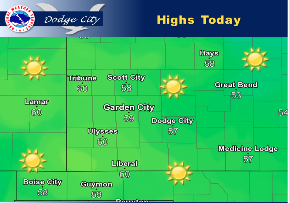
Highs today will top out in the upper 50s with a few reaching around 60 degrees across far southwestern Kansas.

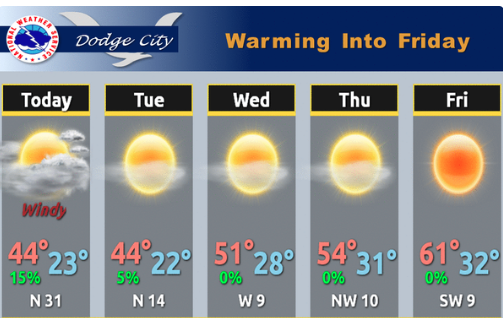
Screen Shot 2016-01-27 at 4.54.14 AMToday Mostly sunny, with a high near 56. West wind 7 to 11 mph.

Tonight Partly cloudy, with a low around 28. West northwest wind around 9 mph.

ThursdaySunny, with a high near 58. West northwest wind 6 to 10 mph.

Thursday NightMostly clear, with a low around 30. Southwest wind 5 to 7 mph.

FridaySunny, with a high near 63. Southwest wind 7 to 10 mph becoming north northwest in the afternoon.

Friday NightPartly cloudy, with a low around 33.

SaturdayMostly sunny, with a high near 60.

Saturday NightMostly cloudy, with a low around 32.

SundayMostly sunny, with a high near 46.

Sunny, warmer Tuesday


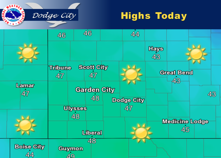
Screen Shot 2016-01-26 at 5.27.32 AMHighs today look to top out in the mid to upper 40s with mostly sunny skies.

Today Sunny, with a high near 43. North wind around 6 mph.

Tonight Mostly clear, with a low around 20. Northeast wind 5 to 7 mph becoming southwest in the evening.

WednesdayMostly sunny, with a high near 53. West wind 7 to 11 mph.

Wednesday NightPartly cloudy, with a low around 27. West northwest wind 7 to 9 mph.

ThursdaySunny, with a high near 58. West northwest wind 7 to 11 mph.

Thursday NightMostly clear, with a low around 31.

FridaySunny, with a high near 62.

Friday NightPartly cloudy, with a low around 33.

SaturdayMostly sunny, with a high near 60.

Cloudy, windy Monday

Today A slight chance of snow and freezing drizzle, mainly between 11am and noon. Mostly cloudy, with a high near 39. Windy, with a north northwest wind 18 to 28 mph. Chance of precipitation is 20%.

Tonight Partly cloudy, with a low around 21. Northwest wind 9 to 17 mph.


Tuesday Sunny, with a high near 40. Northwest wind 9 to 14 mph.

Tuesday NightMostly clear, with a low around 20. North wind 5 to 7 mph becoming west after midnight.

WednesdaySunny, with a high near 49.

Wednesday NightMostly clear, with a low around 28.
ThursdaySunny, with a high near 54.

Thursday NightMostly clear, with a low around 31.

FridaySunny, with a high near 62.

Partly sunny, warmer Friday

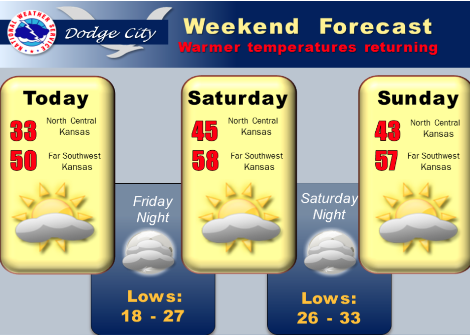
A warm front will gradually move across southwestern Kansas into the Weekend with warmer temperatures.

Screen Shot 2016-01-22 at 5.31.43 AMToday Cloudy, then gradually becoming mostly sunny, with a high near 33. North wind 6 to 10 mph becoming east northeast in the afternoon.

Tonight Partly cloudy, with a low around 18. East wind 6 to 9 mph becoming south after midnight.

SaturdayMostly sunny, with a high near 46. South wind 9 to 14 mph.

Saturday NightMostly cloudy, with a low around 26. South wind 7 to 10 mph.

SundayPartly sunny, with a high near 45. South wind around 7 mph becoming north northeast in the afternoon.

Sunday NightA slight chance of rain and snow before midnight, then a chance of snow between midnight and 4am. Mostly cloudy, with a low around 27. Chance of precipitation is 30%.

MondayPartly sunny, with a high near 39. Breezy.

Cloudy, windy Thursday


High temperatures warm gradually to around 50 by the Weekend with no precipitation expected. The average highs, for this time of year, are around 45 degrees.

Today Patchy snow and freezing drizzle, mainly between 10am and 1pm. Cloudy, with a high near 32. North wind 7 to 16 mph. Chance of precipitation is 30%.

Tonight Mostly cloudy, with a low around 17. North wind 10 to 17 mph.

FridayMostly sunny, with a high near 34. Wind chill values as low as 5. North wind 7 to 10 mph becoming east northeast in the afternoon.

Friday NightPartly cloudy, with a low around 19. East wind 6 to 9 mph becoming south after midnight.

SaturdayMostly sunny, with a high near 46. South wind 9 to 14 mph.

Saturday NightMostly cloudy, with a low around 26.

SundayPartly sunny, with a high near 43.

Sunday NightA slight chance of rain and snow. Mostly cloudy, with a low around 26. Chance of precipitation is 20%.

MondayMostly cloudy, with a high near 38.

Copyright Eagle Radio | FCC Public Files | EEO Public File