We have a brand new updated website! Click here to check it out!

Cloudy, cold with a chance for snow


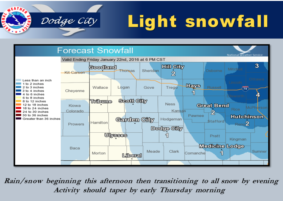
A weak weather system will bring light snowfall amounts today and ending early tomorrow.

Screen Shot 2016-01-20 at 5.36.40 AMToday A chance of rain and snow showers, mainly after 3pm. Areas of freezing fog before 9am. Increasing clouds, with a high near 41. South wind 8 to 14 mph. Chance of precipitation is 40%.

Tonight A 50 percent chance of snow. Cloudy, with a low around 27. South southeast wind 6 to 14 mph becoming north northwest after midnight. New snow accumulation of less than a half inch possible.

ThursdayA 50 percent chance of snow showers. Cloudy, with a high near 33. Breezy, with a north wind 15 to 20 mph. New snow accumulation of less than a half inch possible.

Thursday NightA 20 percent chance of snow showers before 10pm. Mostly cloudy, with a low around 18. Wind chill values as low as 5. North wind 14 to 17 mph.

FridayMostly sunny, with a high near 35. North wind 7 to 13 mph becoming east in the afternoon.

Friday NightMostly clear, with a low around 20.

SaturdayMostly sunny, with a high near 46.
Cloudy, cold and a chance for snow

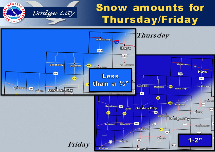
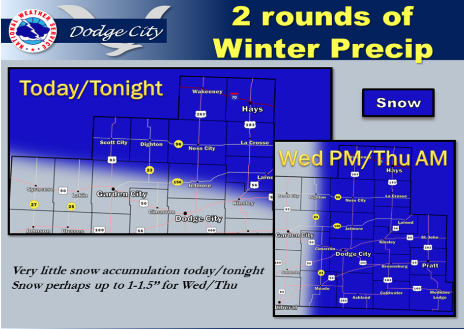
There are two rounds of wintry precipitation this week. The first is today and tonight with very little to no snow accumulation. The second round comes Wednesday evening into Thursday with up to 1.5 inches possible.

Screen Shot 2016-01-19 at 5.32.46 AMToday A slight chance of snow showers between 7am and 4pm. Patchy freezing fog before 8am. Cloudy, with a high near 31. East wind 8 to 13 mph becoming north in the afternoon. Chance of precipitation is 20%.

Tonight Partly cloudy, with a low around 18. North northeast wind 5 to 9 mph becoming light and variable.

WednesdayA slight chance of rain and snow showers after 3pm. Increasing clouds, with a high near 41. South wind 6 to 11 mph increasing to 13 to 18 mph in the morning. Winds could gust as high as 28 mph. Chance of precipitation is 20%.

Wednesday NightA 40 percent chance of snow. Cloudy, with a low around 28. Southeast wind 6 to 14 mph becoming north northwest after midnight.

ThursdayA 30 percent chance of snow, mainly before noon. Mostly cloudy, with a high near 34. Breezy, with a north wind 16 to 21 mph.

Thursday NightPartly cloudy, with a low around 17.

FridayMostly sunny, with a high near 37.

Friday NightPartly cloudy, with a low around 22.

SaturdayMostly sunny, with a high near 47.

Sunny, cold Monday


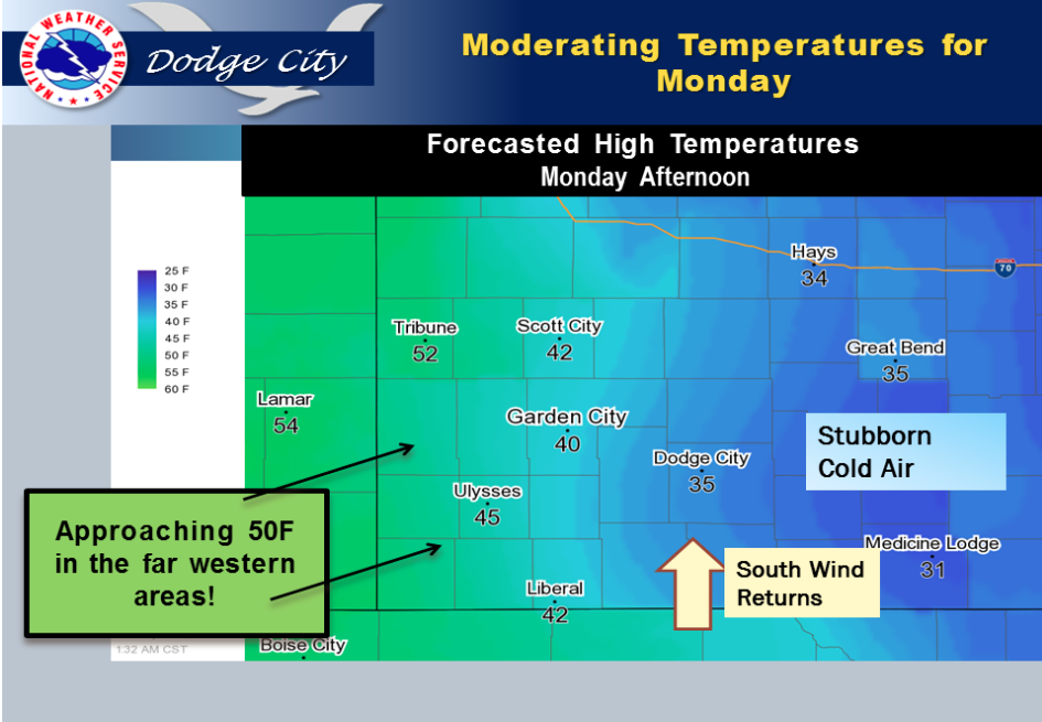
Temperatures begin a slow warming trend for Monday, with the western higher elevation areas warming up much faster than the lower plains.

Screen Shot 2016-01-18 at 5.02.22 AMM.L.King Day Mostly sunny, with a high near 32. Wind chill values as low as 2. South wind 7 to 15 mph.

Tonight Patchy freezing fog after 1am. Mostly cloudy, with a low around 23. Southeast wind around 11 mph.

TuesdayA slight chance of snow between 7am and 4pm. Patchy freezing fog before noon. Cloudy, with a high near 31. East wind 9 to 13 mph becoming north in the afternoon. Chance of precipitation is 20%.

Tuesday NightPartly cloudy, with a low around 21. North wind 5 to 10 mph becoming light and variable.

WednesdayPartly sunny, with a high near 44. South wind 5 to 15 mph.

Wednesday NightA slight chance of rain and snow before 9pm, then a chance of snow. Mostly cloudy, with a low around 25. Chance of precipitation is 30%.

ThursdayA 20 percent chance of snow. Mostly cloudy, with a high near 38.

Thursday NightA 20 percent chance of snow before 7pm. Partly cloudy, with a low around 18.

FridaySunny, with a high near 43.

Sunny, cooler Friday


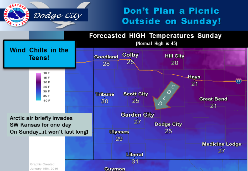
Arctic air will briefly invade SW Kansas for about one day this weekend, with the coldest temperatures expected on Sunday. All locations are expected to remain well below freezing all day Sunday.

Today Mostly sunny, with a high near 43. Northwest wind 8 to 13 mph becoming northeast in the afternoon.

Tonight Mostly cloudy, with a low around 20. East northeast wind 3 to 7 mph.

SaturdayPartly sunny, with a high near 38. East northeast wind 5 to 8 mph becoming west southwest in the afternoon.

Saturday NightIncreasing clouds, with a low around 14. Wind chill values as low as -2. Blustery, with a south southwest wind 5 to 10 mph

becoming north northeast 15 to 20 mph after midnight.

SundayScattered flurries between 8am and 10am. Mostly cloudy, with a high near 20. Blustery, with a north northeast wind 17 to 22 mph

decreasing to 11 to 16 mph in the afternoon.

Sunday NightMostly cloudy, with a low around 11.

M.L.King DayMostly sunny, with a high near 35.

Sunny, warmer Wednesday

A couple of days of above normal high temperatures are in store, before a colder conditions settle in by Friday. Slight chances for snow return by the end of the weekend.

Screen Shot 2016-01-13 at 4.56.43 AMToday Sunny, with a high near 56. Southwest wind 8 to 10 mph.

Tonight Mostly clear, with a low around 28. South southwest wind around 9 mph.

ThursdaySunny, with a high near 54. West southwest wind 8 to 14 mph becoming north northwest in the morning.

Thursday NightPartly cloudy, with a low around 28. North northwest wind 13 to 16 mph.

FridayMostly sunny, with a high near 41. North northwest wind 9 to 13 mph.

Friday NightMostly cloudy, with a low around 23.

SaturdayMostly sunny, with a high near 40.

Saturday NightPartly cloudy, with a low around 18.

SundayMostly cloudy, with a high near 31.

Sunny, mild Tuesday

Mild temperatures in the 40s today…to around 50 degrees Wednesday and Thursday. Cooler with a slight chance for snow by Sunday and Monday.

Screen Shot 2016-01-12 at 5.40.58 AMToday Sunny, with a high near 41. Northwest wind 5 to 9 mph becoming calm.

Tonight Mostly clear, with a low around 21. South southwest wind 6 to 10 mph becoming west after midnight.

Wednesday Sunny, with a high near 54. West wind around 9 mph.

Wednesday Night Clear, with a low around 25. Southwest wind 8 to 10 mph.

ThursdaySunny, with a high near 51. Southwest wind 8 to 11 mph becoming north northwest in the afternoon.

Thursday NightPartly cloudy, with a low around 28.

FridayMostly sunny, with a high near 40.

Friday NightMostly cloudy, with a low around 21.

SaturdayPartly sunny, with a high near 34.

Partly sunny, windy Monday

Weather conditions are forecast to be dry with slightly warmer daily high temperatures heading into mid week.

Screen Shot 2016-01-11 at 5.41.14 AMToday Mostly sunny, with a high near 45. Wind chill values as low as 5 early. Northwest wind 10 to 17 mph.

Tonight Partly cloudy, with a low around 20. Northwest wind 7 to 11 mph.

TuesdaySunny, with a high near 37. North northwest wind 6 to 10 mph becoming east in the afternoon.

Tuesday NightMostly clear, with a low around 20. East southeast wind 6 to 9 mph becoming southwest after midnight.

WednesdaySunny, with a high near 48. West southwest wind 8 to 11 mph.

Wednesday NightClear, with a low around 25.

ThursdaySunny, with a high near 50.

Thursday NightPartly cloudy, with a low around 27.

FridayPartly sunny, with a high near 39. Breezy.

Cloudy, wet Friday

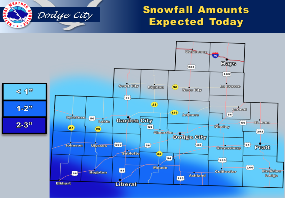
A storm system moving out of the southern Rockies today will bring light snow to portions of southwest Kansas mainly this afternoon and evening. The most significant snowfall amounts are expected along and just north of the Oklahoma border where 1 to 3 inches of snow could accumulate. The snow will be ending by this evening.

Screen Shot 2016-01-08 at 5.00.47 AMToday A slight chance of rain between 3pm and 5pm. Areas of fog before 9am. Otherwise, cloudy, with a high near 34. North wind 11 to 14 mph. Chance of precipitation is 20%.

Tonight A 30 percent chance of snow showers, mainly before 10pm. Cloudy, with a low around 20. North wind 13 to 15 mph.

SaturdayCloudy through mid morning, then gradual clearing, with a high near 24. North wind 13 to 17 mph.

Saturday NightClear, with a low around 8. North wind 6 to 11 mph.

SundaySunny, with a high near 28.

Sunday NightMostly clear, with a low around 16.

MondaySunny, with a high near 40.

Monday NightPartly cloudy, with a low around 20.

Cold, wet Thursday


Today A chance of rain and sleet before noon, then rain likely. Cloudy, with a high near 38. Northeast wind around 9 mph. Chance of precipitation is 70%. New sleet accumulation of less than a half inch possible.

Screen Shot 2016-01-07 at 5.45.52 AMTonight Rain and snow likely, becoming all snow after midnight. Cloudy, with a low around 28. North northwest wind 9 to 11 mph. Chance of precipitation is 60%. New snow accumulation of less than a half inch possible.

Friday A 30 percent chance of snow, mainly after 9am. Cloudy, with a high near 36. North wind 11 to 15 mph.

Friday NightA 50 percent chance of snow, mainly before 4am. Cloudy, with a low around 21. North wind 14 to 17 mph.

SaturdayMostly cloudy, with a high near 26.

Saturday NightMostly cloudy, with a low around 9.

SundayPartly sunny, with a high near 23.


Cloudy, wet Wednesday

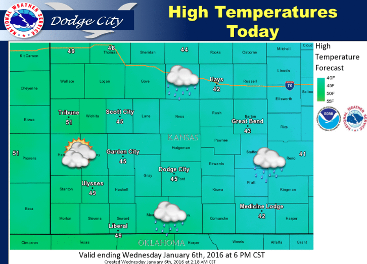
Mostly cloudy today with periods of light rain/drizzle possible through this afternoon. Highs expected in the 40s.

Tonight Areas of drizzle between 9pm and 2am, then areas of drizzle with a chance of showers after 2am. Areas of fog after 9pm. Otherwise, cloudy, with a low around 33. East southeast wind around 6 mph becoming light and variable in the evening. Chance of precipitation is 30%.

Thursday Rain likely, mainly after 8am. Cloudy, with a high near 42. East northeast wind 5 to 10 mph. Chance of precipitation is 70%. New precipitation amounts between a tenth and quarter of an inch possible.

Thursday NightSnow likely, mainly before 8pm. Cloudy, with a low around 27. North wind 8 to 13 mph. Chance of precipitation is 60%.

FridayA 30 percent chance of snow, mainly after 3pm. Cloudy, with a high near 35.

Friday NightA 30 percent chance of snow, mainly before 4am. Cloudy, with a low around 21.

SaturdayMostly cloudy, with a high near 27.

Cloudy, windy Tuesday

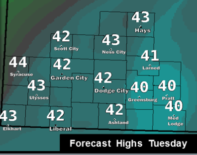
Temperatures continue around seasonal averages with highs in the lower 40s across much of the area. Winds will be on the increase, especially Tuesday, as a trough develops in advance of an upper level storm system.

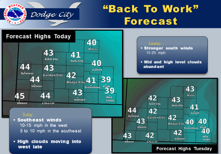
Screen Shot 2016-01-05 at 5.42.05 AMToday Mostly cloudy, with a high near 41. Windy, with a south wind 15 to 25 mph.

Tonight Cloudy, with a low around 33. South wind 11 to 16 mph.

Wednesday Mostly cloudy, with a high near 46. South wind 9 to 14 mph.

Wednesday NightA 40 percent chance of rain, mainly after 3am. Mostly cloudy, with a low around 33. South wind 5 to 8 mph becoming light and variable after midnight.

Thursday Rain likely, mainly between noon and 2pm. Cloudy, with a high near 41. Light east wind becoming north northeast 8 to 13 mph in the morning. Chance of precipitation is 60%. New precipitation amounts between a tenth and quarter of an inch possible.

Thursday Night A chance of rain before midnight, then a chance of snow between midnight and 1am, then a chance of rain after 1am. Cloudy, with a low around 28. Chance of precipitation is 50%.

Friday A 40 percent chance of snow. Cloudy, with a high near 36.

Sunny, cold Monday


Watch for the possibility of precipitation across the region late in the week. This will be a fairly warm system, so precipitation type may be primarily in the form of rain. Some wet snow will be possible, though. At this time, it is not looking like a major precipitation event, although it is still more than 4+ days out.

Today Areas of fog before 9am. Otherwise, mostly sunny, with a high near 40. Southeast wind 5 to 8 mph.

Screen Shot 2016-01-04 at 6.40.48 AMTonight Partly cloudy, with a low around 21. South wind 8 to 14 mph.

Tuesday Partly sunny, with a high near 43. Breezy, with a south wind 14 to 20 mph.

Tuesday Night Mostly cloudy, with a low around 29. South wind 13 to 17 mph.

WednesdayMostly cloudy, with a high near 44. South wind 9 to 13 mph.

Wednesday NightA 30 percent chance of rain after 7pm. Mostly cloudy, with a low around 34.

ThursdayA 50 percent chance of rain. Cloudy, with a high near 44.

Screen Shot 2016-01-04 at 5.33.21 AMThursday NightA chance of rain before 7pm, then a chance of rain and snow. Cloudy, with a low around 30. Chance of precipitation is 50%.

FridayA chance of rain and snow. Cloudy, with a high near 39. Chance of precipitation is 40%.

Sunny, warmer New Year’s Day

Temperatures are expected to return to near seasonal averages by this weekend.
Screen Shot 2015-12-31 at 7.25.07 PMNew Year’s Day
Sunny, with a high near 42. Wind chill values as low as 1. West northwest wind 8 to 13 mph.

Friday Night Clear, with a low around 17. West wind around 7 mph.

SaturdaySunny, with a high near 45. West northwest wind 6 to 11 mph.

Saturday NightMostly clear, with a low around 17. West northwest wind 5 to 8 mph.

SundaySunny, with a high near 42.

Sunday NightMostly clear, with a low around 19.

MondaySunny, with a high near 39.

Copyright Eagle Radio | FCC Public Files | EEO Public File