We have a brand new updated website! Click here to check it out!

Cloudy, cool Wednesday

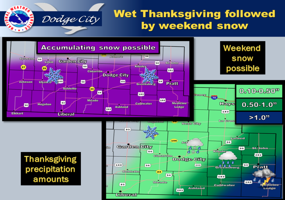
Freezing rain and sleet expected across west central and portions of southwest Kansas Thanksgiving day. Hazardous driving conditions likely

Screen Shot 2015-11-25 at 5.28.50 AMToday Areas of fog before 9am. Otherwise, mostly cloudy, with a high near 57. South wind 5 to 8 mph becoming light and variable.

Tonight A 50 percent chance of rain, mainly after 1am. Mostly cloudy, with a low around 35. North northeast wind 8 to 16 mph.

Thanksgiving Day Rain, freezing rain, and sleet before 3pm, then snow, possibly mixed with sleet. Temperature falling to around 24 by 5pm. Breezy, with a north wind 15 to 23 mph. Chance of precipitation is 80%. New ice accumulation of less than a 0.1 of an inch possible. New snow and sleet accumulation of less than a half inch possible.

Thursday Night Snow, mainly before 1am. Low around 22. Blustery, with a north wind 21 to 23 mph. Chance of precipitation is 80%. New snow Screen Shot 2015-11-25 at 5.30.17 AMaccumulation of less than one inch possible.

FridayA 50 percent chance of snow. Mostly cloudy, with a high near 28. Blustery, with a north wind 17 to 21 mph.

Friday NightA 20 percent chance of snow. Cloudy, with a low around 22.

SaturdayA 40 percent chance of snow, mainly after 7am. Cloudy, with a high near 28.

Saturday NightA 40 percent chance of snow. Mostly cloudy, with a low around 23.

SundayA 40 percent chance of snow, mainly before 7am. Mostly cloudy, with a high near 33.

Sunny, mild Tuesday

There is an increasing concern that hazardous travel conditions with icy roads may prevail for Thanksgiving. Keep updated with future forecasts!

Today Sunny, with a high near 59. South wind 5 to 14 mph.

Screen Shot 2015-11-24 at 5.50.05 AMTonight Increasing clouds, with a low around 35. South southeast wind 7 to 9 mph.

WednesdayPartly sunny, with a high near 58. South wind 7 to 9 mph becoming northeast in the afternoon.

Wednesday NightA 50 percent chance of rain, mainly after 2am. Mostly cloudy, with a low around 35. North northeast wind 10 to 17 mph.

Thanksgiving DayRain and sleet likely, possibly mixed with snow before 3pm, then snow likely, possibly mixed with sleet between 3pm and 5pm, then snow likely after 5pm. Cloudy, with a temperature falling to around 29 by 5pm. Breezy, with a north northeast wind 15 to 22 mph. Chance of precipitation is 60%. New precipitation amounts between a quarter and half of an inch possible.

Thursday NightSnow likely, mainly before 7pm. Mostly cloudy, with a low around 22. Blustery. Chance of precipitation is 60%.

FridayA 20 percent chance of snow. Mostly cloudy, with a high near 30.

Friday NightA 20 percent chance of snow. Mostly cloudy, with a low around 23.

SaturdayA 30 percent chance of snow. Mostly cloudy, with a high near 34.

Sunny, warmer Monday

Thanksgiving is looking to be fairly wet across south-central Kansas. Another disturbance could bring a few inches of snow possible by late Saturday into Sunday.

Screen Shot 2015-11-23 at 5.40.56 AMToday Sunny, with a high near 63. Light and variable wind becoming south southeast 8 to 13 mph in the afternoon.

Tonight Mostly clear, with a low around 32. South southeast wind 9 to 11 mph.

TuesdaySunny, with a high near 57. South wind 9 to 15 mph.

Tuesday NightIncreasing clouds, with a low around 37. South wind 7 to 9 mph.

WednesdayPartly sunny, with a high near 62. South wind 8 to 13 mph.

Wednesday NightA 40 percent chance of rain, mainly after midnight. Mostly cloudy, with a low around 38.

Thanksgiving DayRain likely before noon, then rain and snow likely. Cloudy, with a high near 40. Breezy. Chance of precipitation is 60%. New precipitation amounts of less than a tenth of an inch possible.

Thursday NightA 40 percent chance of snow. Mostly cloudy, with a low around 22. Blustery.

FridayPartly sunny, with a high near 31.

Partly sunny, windy Friday


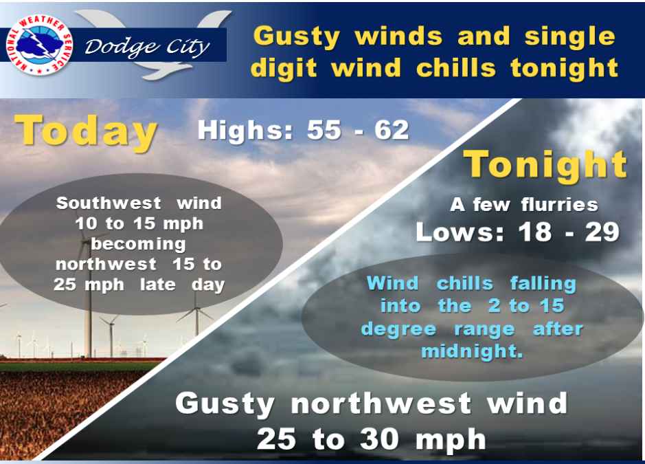
Screen Shot 2015-11-20 at 5.35.55 AMGusty northwest winds expected behind a cold front which will cross southwest Kansas during the afternoon. As cold air invades western Kansas overnight gusty northwest winds will be at 25 to 30 mph. This will result in wind chills falling back into the 2 to 15 degree range after midnight.

Today Partly sunny, with a high near 56. Windy, with a south wind 9 to 14 mph becoming north northwest 20 to 25 mph in the afternoon.

Tonight Scattered flurries before 1am. Mostly cloudy, with a low around 23. Windy, with a north wind 21 to 29 mph.

Saturday Sunny, with a high near 38. Breezy, with a north northwest wind 15 to 20 mph becoming west southwest 7 to 12 mph in the afternoon.

Saturday NightMostly clear, with a low around 20. West southwest wind 7 to 10 mph.

SundaySunny, with a high near 51. West northwest wind 9 to 13 mph.

Sunday NightClear, with a low around 28.

MondaySunny, with a high near 57.

Monday NightMostly clear, with a low around 31.

Sunny, cooler Thursday

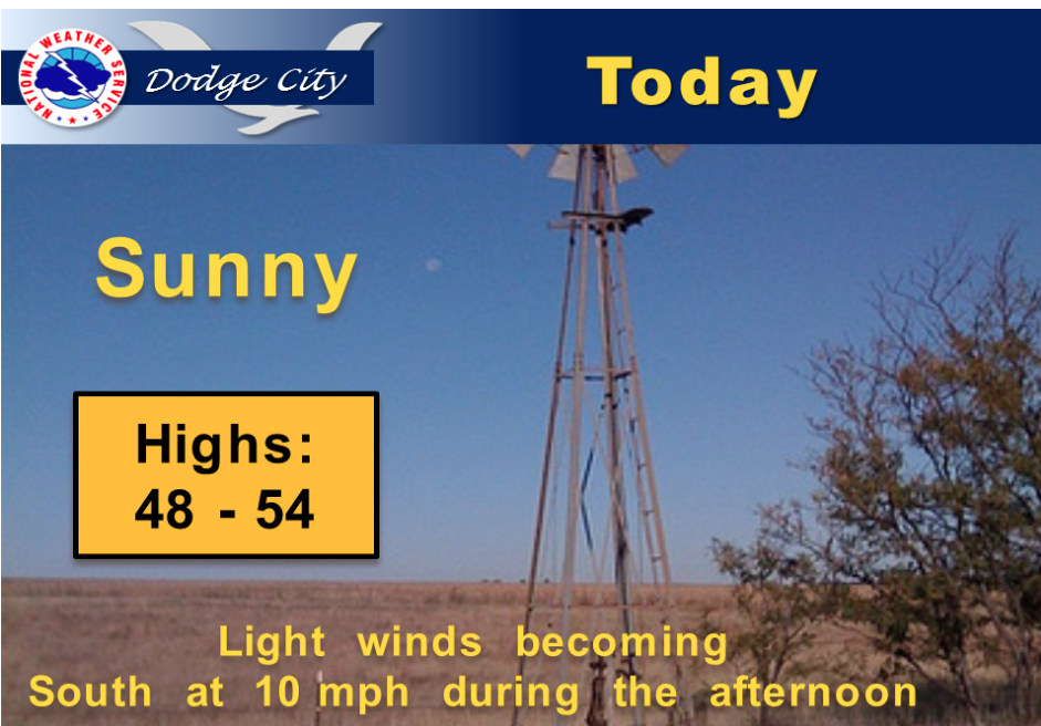
Highs today will average 5 to 10 degrees cooler compared to the highs yesterday.

Screen Shot 2015-11-19 at 5.47.27 AMToday Sunny, with a high near 51. Southwest wind 7 to 9 mph.

Tonight Partly cloudy, with a low around 31. South wind 7 to 13 mph.

FridayPartly sunny, with a high near 53. Breezy, with a south wind 13 to 20 mph becoming west in the afternoon.

Friday NightScattered sprinkles before 11pm, then scattered flurries between 11pm and 2am. Mostly cloudy, with a low around 21. Windy, with a north wind 18 to 23 mph increasing to 24 to 29 mph in the evening.

SaturdaySunny, with a high near 37. North northwest wind 9 to 18 mph, with gusts as high as 28 mph.

Saturday NightMostly clear, with a low around 23.

SundaySunny, with a high near 48.

Sunday NightClear, with a low around 27.

MondaySunny, with a high near 56.

Cool, windy Wednesday

Breezy westerly winds will continue today. Clouds will quickly clear from west to east early this morning, allowing temperatures to warm into the upper 50s and low 60s. Highs could be slightly cooler in the extreme west central sections of the area, mainly west and northwest of the Syracuse area where several inches of snow fell yesterday. Another weather system will dive through the northern High Plains bringing another round of rain and now mainly across Nebraska later today. Pacific high pressure will overspread the area on Thursday, and bring slightly cooler high temperatures in the low 50s. The rest of the week looks mainly dry and seasonal temperature-wise for southwest and central Kansas.

Screen Shot 2015-11-18 at 5.20.08 AMToday Partly sunny, with a high near 55. Breezy, with a west wind 13 to 21 mph.

Tonight Mostly clear, with a low around 24. North northwest wind 8 to 16 mph.

ThursdayMostly sunny, with a high near 51. West wind 7 to 11 mph.

Thursday NightPartly cloudy, with a low around 29. South southwest wind 5 to 9 mph.

FridayPartly sunny, with a high near 48.

Friday NightA slight chance of rain and snow before 7pm, then a slight chance of snow. Partly cloudy, with a low around 24. Chance of precipitation is 20%.

SaturdayA 20 percent chance of snow before 7am. Sunny, with a high near 40.

Saturday NightPartly cloudy, with a low around 25.

SundaySunny, with a high near 47.

Windy, wet Tuesday


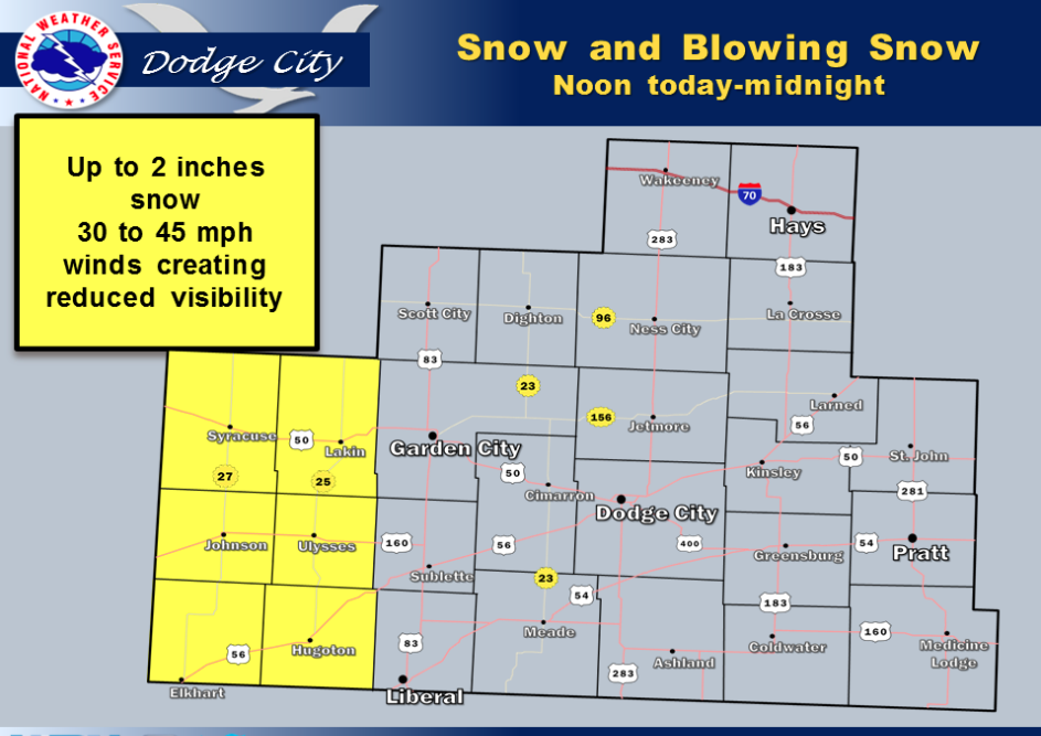
Strong winds in the 30 to 45 mph range will develop over western Kansas this morning. In addition, a broken band of light snow will move eastward out of eastern Colorado as early as around noon. Precipitation could begin as rain before changing over to snow. Snow amounts are expected to be relatively minor, however in combination with the winds, may produce a period of hazardous travel conditions by reducing visibility in blowing snow an making roads slick. Areas affected the greatest will be generally west of Lakin, to Syracuse and along the Kansas-Colorado line. Mid afternoon through early evening is the period of the most likely deteriorating travel conditions.

Screen Shot 2015-11-17 at 5.14.55 AMToday A 50 percent chance of rain. Partly sunny, with a temperature falling to around 45 by 5pm. East northeast wind 9 to 13 mph becoming northwest in the afternoon.

Tonight A 50 percent chance of snow, mainly before 3am. Mostly cloudy, with a low around 32. Breezy, with a northwest wind 11 to 16 mph increasing to 17 to 22 mph after midnight. Little or no snow accumulation expected.

WednesdayMostly sunny, with a high near 57. West wind 14 to 17 mph.

Wednesday NightPartly cloudy, with a low around 28. North northwest wind 7 to 15 mph.

ThursdayMostly sunny, with a high near 51.

Thursday NightPartly cloudy, with a low around 30.

FridayMostly sunny, with a high near 52.

Friday NightPartly cloudy, with a low around 27.

SaturdayMostly sunny, with a high near 41.

Cloudy, breezy with a chance of Monday thunderstorms

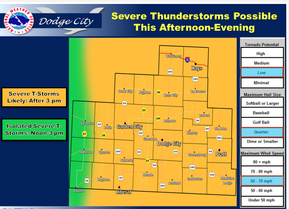
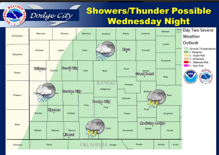
A late season severe thunderstorm event is possible over portions of western & central Kansas today into tonight

Screen Shot 2015-11-16 at 5.43.35 AMToday A 30 percent chance of showers and thunderstorms, mainly after 5pm. Mostly cloudy, with a high near 68. Breezy, with a south wind 16 to 21 mph.

Tonight Showers and thunderstorms likely, mainly before midnight, then a chance of rain after 5am. Cloudy, with a low around 43. South wind 9 to 17 mph. Chance of precipitation is 60%. New rainfall amounts between a quarter and half of an inch possible.

TuesdayA chance of rain and snow. Cloudy, with a high near 45. Breezy, with an east southeast wind 9 to 14 mph becoming north northwest 17 to 22 mph in the afternoon. Chance of precipitation is 50%. Little or no snow accumulation expected.

Tuesday NightA chance of rain and snow before midnight, then a chance of snow between midnight and 4am. Mostly cloudy, with a low around 31. Blustery, with a northwest wind 14 to 24 mph. Chance of precipitation is 50%. Little or no snow accumulation expected.

WednesdayMostly sunny, with a high near 57. West wind 11 to 17 mph.

Wednesday NightPartly cloudy, with a low around 30.

ThursdayMostly sunny, with a high near 50.

Sunny, warmer Friday


Mild fall weather will continue today and Saturday with highs in the low to mid 60s. Cloudiness will increase Sunday as low level moisture flows north from the Gulf into central and eastern Kansas. Temperatures will be a few degrees cooler in central Kansas Sunday as a conseqence of the cloud cover. A few showers also can be expected Sunday afternoon east of Highway 283 as an upper level trough approaches Kansas.

Today Sunny, with a high near 60. Southwest wind 6 to 14 mph.

Screen Shot 2015-11-13 at 7.18.44 AMTonight Clear, with a low around 36. South southwest wind around 8 mph.

SaturdaySunny, with a high near 65. South southwest wind 7 to 12 mph increasing to 13 to 18 mph in the afternoon. Winds could gust as high as 28 mph.

Saturday NightIncreasing clouds, with a low around 40. South wind 10 to 13 mph.

SundayA 20 percent chance of showers after 3pm. Partly sunny, with a high near 59. Breezy, with a south wind 10 to 15 mph increasing to 17 to 22 mph in the morning.

Sunday NightA 20 percent chance of showers before 2am. Mostly cloudy, with a low around 48. Breezy.

MondayMostly sunny, with a high near 65.

Monday NightShowers likely. Mostly cloudy, with a low around 42. Chance of precipitation is 60%. New precipitation amounts between a half and three quarters of an inch possible.

Sunny, breezy Thursday


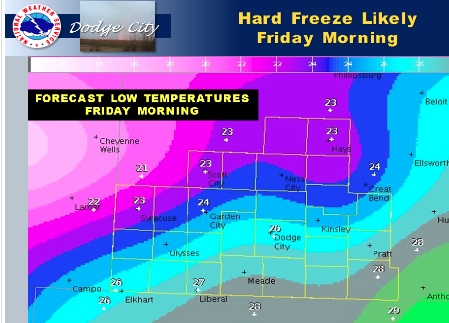
Highs will be in the 50s today with clear skies and northwest winds 10 to 15 mph. Radiational cooling tonight will allow temperatures to fall into the low to mid 20s across much of southwest Kansas. This will be the first hard freeze this fall for many locations.

Screen Shot 2015-11-12 at 5.31.51 AMToday Sunny, with a high near 54. Northwest wind 11 to 16 mph.

Tonight Mostly clear, with a low around 24. West northwest wind 5 to 8 mph.

Friday Sunny, with a high near 60. Southwest wind 5 to 14 mph.

Friday NightClear, with a low around 33. South southwest wind around 9 mph.

SaturdaySunny, with a high near 65. South southwest wind 9 to 18 mph, with gusts as high as 28 mph.

Saturday NightMostly clear, with a low around 38.

SundayMostly sunny, with a high near 62.

Sunday NightMostly cloudy, with a low around 44.

High wind warning for Veterans Day

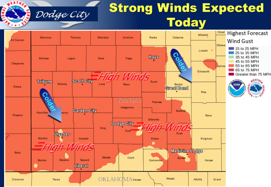
Strong northwesterly winds with gusts in excess of 50 mph will develop behind a cold front moving across western Kansas through mid afternoon.

Screen Shot 2015-11-11 at 5.34.58 AMVeterans Day A 30 percent chance of showers, mainly before 2pm. Areas of blowing dust between 9am and 5pm. Increasing clouds, with a high near 46. Very windy, with a south wind 14 to 24 mph becoming northwest 30 to 40 mph. Winds could gust as high as 60 mph.

Tonight Mostly clear, with a low around 32. Windy, with a west northwest wind 23 to 28 mph decreasing to 14 to 19 mph after midnight. Winds could gust as high as 43 mph.

ThursdaySunny, with a high near 55. Northwest wind 11 to 18 mph, with gusts as high as 28 mph.

Thursday NightMostly clear, with a low around 25. West wind 6 to 8 mph.

FridaySunny, with a high near 58. South southwest wind 5 to 10 mph increasing to 13 to 18 mph in the afternoon.

Friday NightClear, with a low around 34.

SaturdaySunny, with a high near 63.

Saturday NightClear, with a low around 36.

SundaySunny, with a high near 63.

Partly sunny, mild Tuesday

Screen Shot 2015-11-10 at 5.15.27 AM

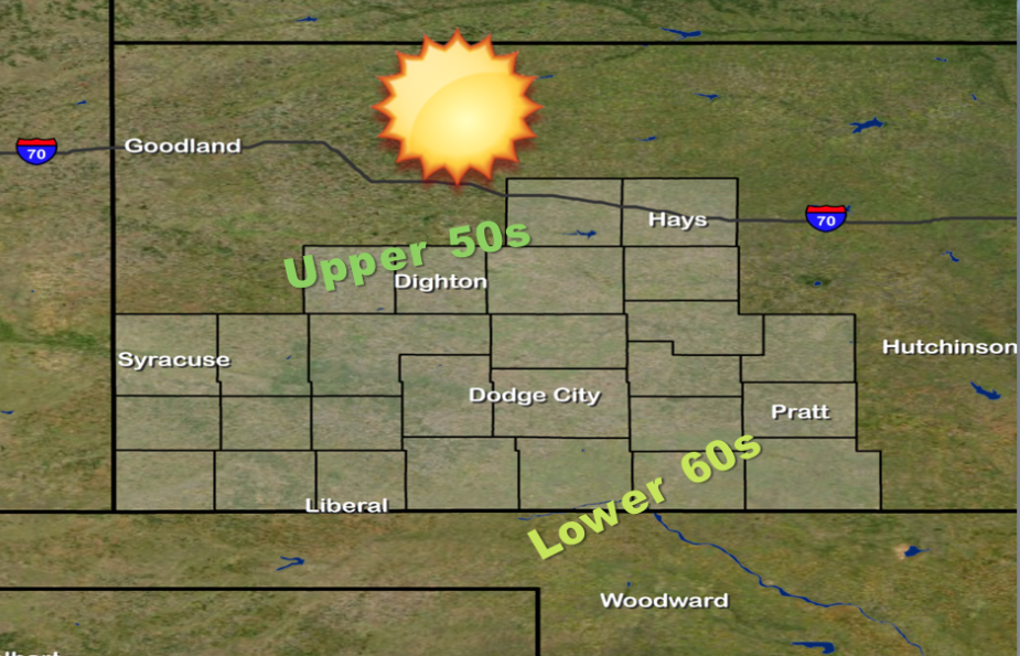
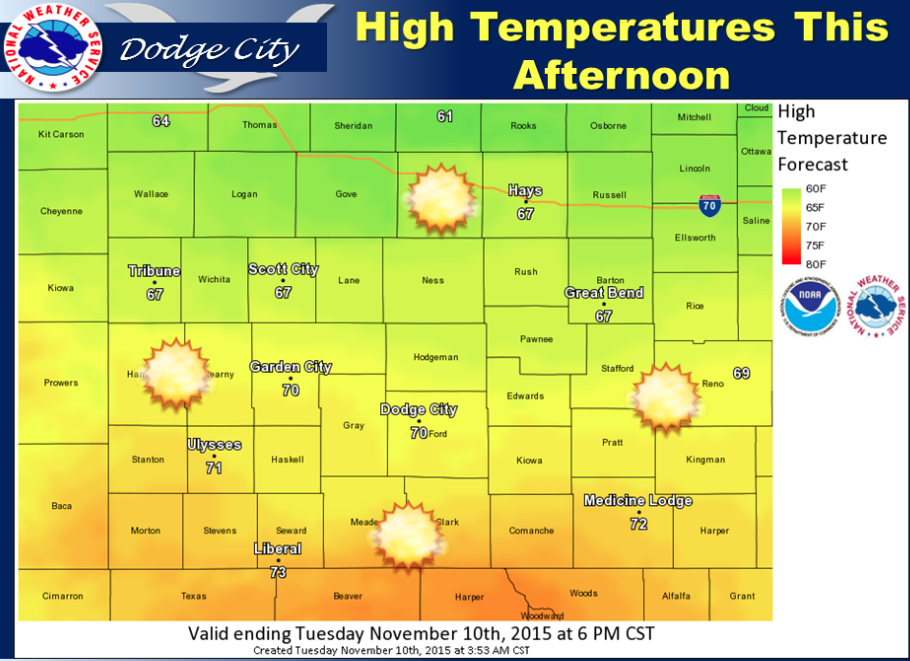
Mostly sunny today with highs in the upper 60s and the lower to mid 70s this afternoon.

Today Patchy fog before 8am. Otherwise, mostly sunny, with a high near 67. Light and variable wind becoming southeast 5 to 10 mph in the afternoon.

Tonight Partly cloudy, with a low around 47. South wind 7 to 14 mph.

Veterans Day A slight chance of showers between 8am and 5pm. Partly sunny, with a high near 51. Very windy, with a south wind 14 to 24 mph becoming northwest 31 to 41 mph. Winds could gust as high as 60 mph. Chance of precipitation is 20%.

Wednesday NightMostly clear, with a low around 33. Very windy, with a west northwest wind 26 to 31 mph decreasing to 13 to 18 mph after midnight.

ThursdaySunny, with a high near 55. Breezy, with a northwest wind 11 to 21 mph.

Thursday NightMostly clear, with a low around 25.

FridaySunny, with a high near 55.

Friday NightClear, with a low around 34.

Sunny, windy Monday

CarZone-728x90
Screen Shot 2015-11-09 at 5.27.10 AM

Highs on Monday look to reach into the lower to mid 60s.

Today Sunny, with a high near 65. South wind 8 to 18 mph.

Tonight Mostly clear, with a low around 41. South southeast wind 5 to 11 mph.

TuesdayMostly sunny, with a high near 69. Light south southeast wind increasing to 5 to 10 mph in the morning.

Tuesday NightA 20 percent chance of rain after 5am. Partly cloudy, with a low around 47. East southeast wind 5 to 13 mph becoming south southwest after midnight.

Veterans DayA 30 percent chance of rain, mainly before 3pm. Partly sunny, with a high near 50. Very windy, with a west southwest wind 14 to 24 mph becoming northwest 27 to 37 mph. Winds could gust as high as 55 mph.

Wednesday NightMostly clear, with a low around 33. Very windy.

ThursdaySunny, with a high near 56.

Thursday NightMostly clear, with a low around 28.

FridaySunny, with a high near 54.

Copyright Eagle Radio | FCC Public Files | EEO Public File