We have a brand new updated website! Click here to check it out!

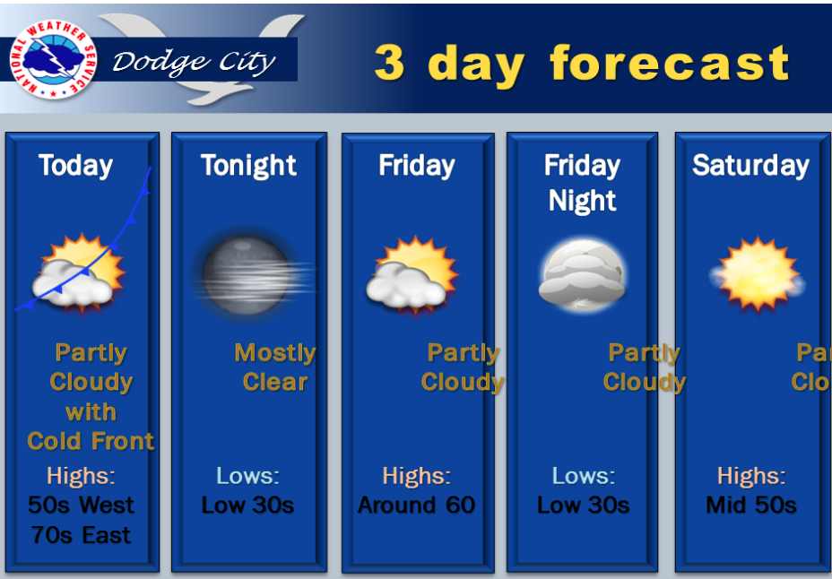
Partly sunny, cooler Friday

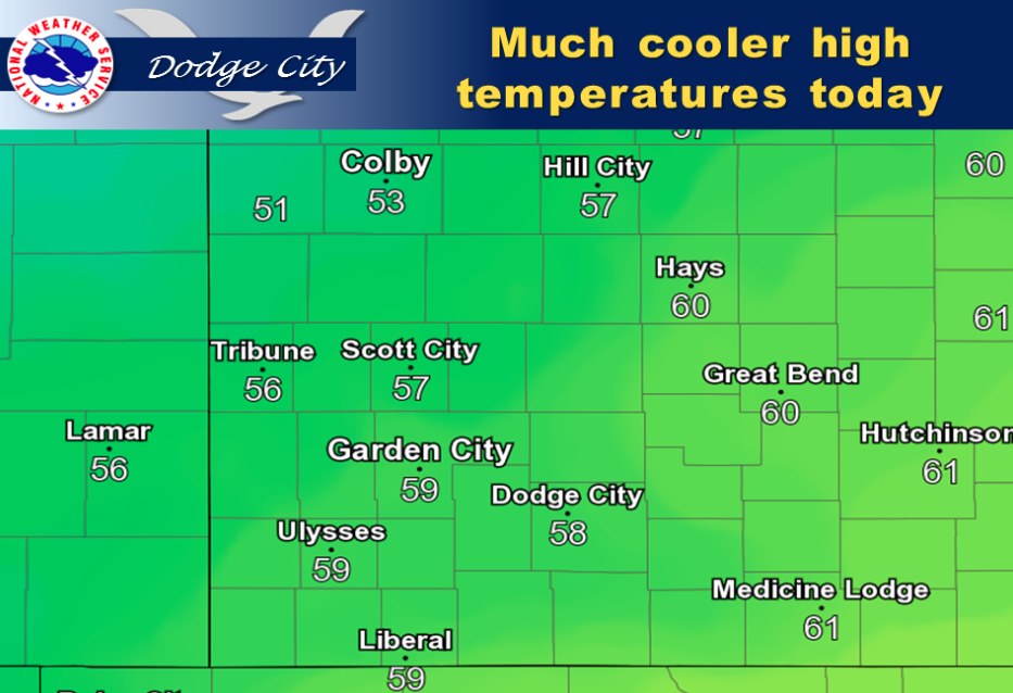
Temperatures will be much cooler today as high pressure builds into the area.

Screen Shot 2015-11-06 at 5.33.15 AMToday Partly sunny, with a high near 60. West northwest wind 5 to 10 mph becoming light and variable in the afternoon.

Tonight Mostly cloudy, then gradually becoming clear, with a low around 30. Light north northeast wind becoming north 8 to 13 mph.

SaturdaySunny, with a high near 55. Light and variable wind becoming south 5 to 7 mph in the morning.

Saturday NightClear, with a low around 34. South wind 7 to 10 mph.

SundaySunny, with a high near 60. Breezy, with a south wind 9 to 14 mph increasing to 18 to 23 mph in the afternoon.

Sunday NightMostly clear, with a low around 38.

MondaySunny, with a high near 64.

Monday NightMostly clear, with a low around 43.

Windy, cooler Thursday


Screen Shot 2015-11-05 at 5.27.19 AMToday Mostly sunny, with a high near 63. South southwest wind 11 to 18 mph becoming northwest in the afternoon. Winds could gust as high as 28 mph.

Tonight Areas of frost after 3am. Otherwise, mostly clear, with a low around 33. Breezy, with a northwest wind 15 to 20 mph becoming west 5 to 10 mph after midnight.

Friday Areas of frost before 7am. Otherwise, mostly sunny, with a high near 60. Southwest wind around 7 mph becoming north in the afternoon.

Friday  NightA slight chance of showers between 7pm and 11pm. Partly cloudy, with a low around 31. North wind 7 to 11 mph. Chance of precipitation is 20%.

Saturday Sunny, with a high near 54. North wind around 8 mph becoming south southeast in the afternoon.

Saturday Night Mostly clear, with a low around 35.

Sunday Sunny, with a high near 60. Breezy.

Warm, windy Wednesday


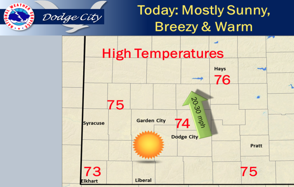
Mostly sunny, breezy and warm conditions can be expected today with highs mainly in the mid 70s.

Screen Shot 2015-11-04 at 5.48.57 AMToday Mostly sunny, with a high near 77. Windy, with a south wind 15 to 25 mph.

Tonight A 50 percent chance of showers and thunderstorms, mainly before 3am. Mostly cloudy, with a low around 52. Breezy, with a south wind 16 to 22 mph.

ThursdayMostly sunny, with a high near 64. South southwest wind 14 to 16 mph becoming northwest in the afternoon.

Thursday NightMostly clear, with a low around 35. Northwest wind 6 to 13 mph.

FridayMostly sunny, with a high near 59. West northwest wind 6 to 11 mph.

Friday NightPartly cloudy, with a low around 36.

SaturdaySunny, with a high near 57.

Saturday NightMostly clear, with a low around 38.

SundaySunny, with a high near 62. Breezy.

Sunday NightPartly cloudy, with a low around 43. Breezy.

Sunny, warm Monday


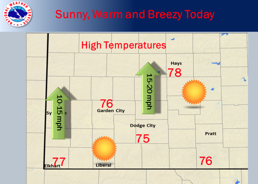
It will be sunny today with highs in the mid to upper 70s. Breezy south winds can be expected, especially from Garden City eastward into central Kansas.

Today Sunny, with a high near 78. South wind 6 to 15 mph.

Tonight Mostly clear, with a low around 49. South wind 11 to 14 mph.

TuesdaySunny, with a high near 78. Breezy, with a south wind 14 to 24 mph.

Screen Shot 2015-11-02 at 5.47.50 AMTuesday NightMostly clear, with a low around 52. Breezy, with a south wind 14 to 20 mph.

WednesdaySunny, with a high near 76. Breezy, with a south southwest wind 13 to 18 mph increasing to 19 to 24 mph in the afternoon.

Wednesday NightA 40 percent chance of showers and thunderstorms, mainly after 2am. Partly cloudy, with a low around 50.

ThursdayA 40 percent chance of showers and thunderstorms. Partly sunny, with a high near 63.

Thursday NightA 20 percent chance of showers. Partly cloudy, with a low around 35.

FridayMostly sunny, with a high near 56.

Cool, wet Friday


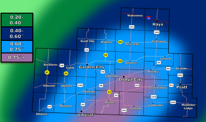
Rainfall totals through Friday night may exceed 3/4ths of an inch in some places

Today Showers, mainly after noon. High near 50. Southeast wind 5 to 10 mph. Chance of precipitation is 90%. New precipitation amounts between a quarter and half of an inch possible.

Tonight Showers, mainly before midnight. Low around 40. East wind 5 to 7 mph becoming light and variable after midnight. Chance of precipitation is 80%. New precipitation amounts between a tenth and quarter of an inch possible.

SaturdayPartly sunny, then gradually becoming sunny, with a high near 69. West northwest wind 5 to 10 mph.

Saturday NightClear, with a low around 41. South wind around 6 mph becoming west southwest after midnight.

SundaySunny, with a high near 76. West southwest wind 5 to 10 mph.

Sunday NightMostly clear, with a low around 44.

MondaySunny, with a high near 74.

Monday NightMostly clear, with a low around 49.

TuesdaySunny, with a high near 74.

Sunny, cooler Thursday


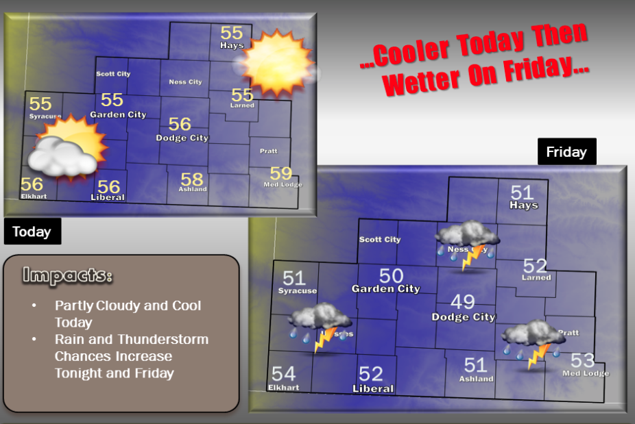
A cold front moving through southwest Kansas will bring cooler temperatures to the area today. Highs will be topping out in the mid to upper 50s. A storm system moving out east out of the Rockies will bring increasing chances for rain and a few thunderstorms to the area starting late tonight and continuing through Friday before ending Friday night.

Today Mostly sunny, with a high near 55. North wind 3 to 8 mph.

Tonight A slight chance of showers between 3am and 4am, then a slight chance of showers and thunderstorms after 4am. Mostly cloudy, with a low around 39. Southeast wind around 8 mph. Chance of precipitation is 20%.

Screen Shot 2015-10-29 at 5.41.14 AMFriday A chance of showers and thunderstorms before 10am, then showers likely and possibly a thunderstorm between 10am and 1pm, then showers likely after 1pm. Cloudy, with a high near 51. South southeast wind 8 to 13 mph. Chance of precipitation is 70%. New rainfall amounts between a quarter and half of an inch possible.

Friday NightShowers likely, mainly before 10pm. Cloudy, with a low around 41. East wind 6 to 9 mph becoming northwest after midnight. Chance of precipitation is 60%. New precipitation amounts between a tenth and quarter of an inch possible.

SaturdayMostly sunny, with a high near 66.

Saturday NightClear, with a low around 41.

SundaySunny, with a high near 73.

Sunday NightClear, with a low around 44.

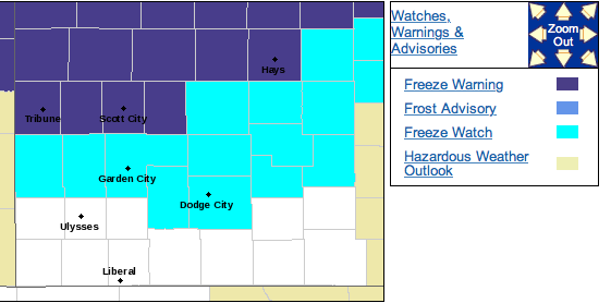
Sunny Wednesday, freeze warning overnight


Today Sunny, with a high near 63. Northwest wind 11 to 16 mph.

NWS Freeze warning map-click to ENLARGE

Tonight Areas of frost after 4am. Otherwise, mostly clear, with a low around 30. West northwest wind 5 to 8 mph becoming north after midnight.

ThursdayAreas of frost before 10am. Otherwise, mostly sunny, with a high near 55. North wind 5 to 7 mph becoming calm in the afternoon.

Thursday NightMostly cloudy, with a low around 39. South southeast wind 7 to 9 mph.

FridayShowers likely, mainly after noon. Cloudy, with a high near 51. South wind 6 to 15 mph. Chance of precipitation is 70%. New precipitation amounts between a quarter and half of an inch possible.

Friday NightShowers likely, mainly before 10pm. Cloudy, with a low around 41. Chance of precipitation is 60%. New precipitation amounts between a tenth and quarter of an inch possible.

SaturdayA 10 percent chance of showers before 7am. Mostly sunny, with a high near 63.

Saturday NightMostly clear, with a low around 41.

SundaySunny, with a high near 71.

Mild, chance of Tuesday showers


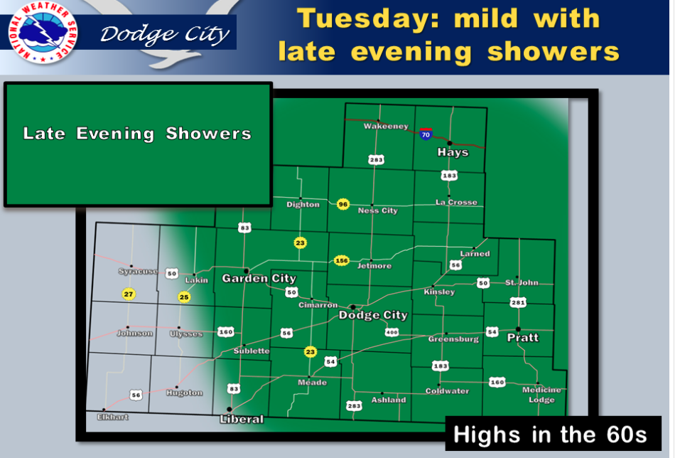
Mild today with late evening showers possible.

Today A 30 percent chance of showers, mainly before 9am. Cloudy through mid morning, then gradual clearing, with a high near 63. Calm wind becoming south southeast around 5 mph.

Screen Shot 2015-10-27 at 5.30.26 AMTonight A 30 percent chance of showers, mainly between 11pm and 4am. Mostly clear during the early evening, then becoming mostly cloudy, with a low around 42. Light and variable wind becoming northwest 13 to 18 mph in the evening. Winds could gust as high as 28 mph.

WednesdaySunny, with a high near 63. Breezy, with a northwest wind 15 to 21 mph.

Wednesday NightClear, with a low around 33. Light and variable wind becoming north 5 to 10 mph after midnight.

ThursdayMostly sunny, with a high near 56.

Thursday NightA 10 percent chance of showers after 5am. Mostly cloudy, with a low around 41.

FridayShowers likely, mainly after 7am. Mostly cloudy, with a high near 55. Chance of precipitation is 60%. New precipitation amounts between a tenth and quarter of an inch possible.

Friday NightA 50 percent chance of showers. Cloudy, with a low around 42.

SaturdayMostly sunny, with a high near 61.

Partly sunny, breezy Monday


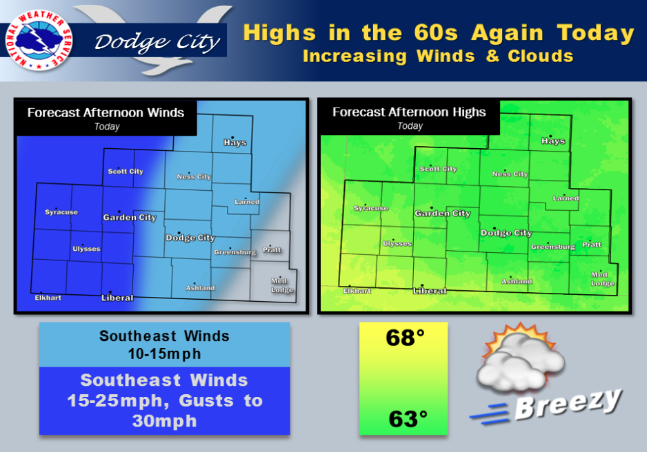
High clouds will be on the increase, along with southeast winds this afternoon. Afternoon temperatures are forecast to top out in the 60s once again across the southwest Kansas region.

Screen Shot 2015-10-26 at 5.57.00 AMToday Partly sunny, with a high near 64. South wind 5 to 10 mph increasing to 11 to 16 mph in the afternoon.

Tonight A 20 percent chance of showers after 4am. Mostly cloudy, with a low around 39. Southeast wind 6 to 11 mph.

TuesdayA slight chance of showers before 11am, then a slight chance of showers and thunderstorms after 4pm. Partly sunny, with a high near 65. South wind 5 to 9 mph. Chance of precipitation is 20%.

Tuesday NightA slight chance of showers and thunderstorms before 10pm, then a slight chance of showers between 10pm and 3am. Partly cloudy, with a low around 41. South wind 8 to 16 mph becoming northwest after midnight. Chance of precipitation is 20%.

WednesdaySunny, with a high near 63. Northwest wind 14 to 18 mph, with gusts as high as 28 mph.

Wednesday NightMostly clear, with a low around 35.

ThursdayMostly sunny, with a high near 57.

Thursday NightA 20 percent chance of showers. Partly cloudy, with a low around 38.

FridayA 20 percent chance of showers. Partly sunny, with a high near 57.

Partly sunny, windy Friday


Low clouds this morning are expected to scatter out later on today with sunshine prevailing by afternoon. A wind shift will occur to the northwest by afternoon with an increase in speed to 15 to 25mph. Highs will range from the mid 60s over far west central KS to the mid 70s across far south central Kansas.

Screen Shot 2015-10-23 at 5.43.09 AMToday Patchy fog before 10am. Otherwise, partly sunny, with a high near 69. South wind 11 to 18 mph becoming west northwest in the afternoon. Winds could gust as high as 28 mph.

Tonight Partly cloudy, with a low around 40. Northwest wind 9 to 14 mph.

SaturdaySunny, with a high near 65. North wind 5 to 10 mph.

Saturday NightClear, with a low around 36. Northeast wind around 5 mph becoming south after midnight.

SundaySunny, with a high near 68. South wind 5 to 9 mph.

Sunday NightPartly cloudy, with a low around 42.

MondayPartly sunny, with a high near 66.


Windy, wet Thursday

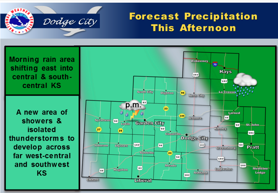
The main body of this precipitation event will be on the move toward the east by midday and early afternoon into central Kansas. The upper low will still be out west across the Rockies, so expect a new round of showers and isolated thunderstorms to develop this afternoon across portions of west central and southwest KS. This second round this afternoon is not expected to be as widespread in coverage.

Screen Shot 2015-10-22 at 5.42.08 AMToday Showers and possibly a thunderstorm. High near 66. Windy, with an east wind 11 to 16 mph becoming south southeast 20 to 25 mph in the afternoon. Chance of precipitation is 100%. New rainfall amounts between a half and three quarters of an inch possible.

Tonight Showers likely and possibly a thunderstorm before 11pm, then a chance of showers and thunderstorms after 11pm. Mostly cloudy, with a low around 52. South southeast wind 11 to 16 mph. Chance of precipitation is 60%. New rainfall amounts between a quarter and half of an inch possible.

FridayA 20 percent chance of showers and thunderstorms before 11am. Partly sunny, with a high near 71. South southwest wind 10 to 13 mph becoming northwest in the afternoon.

Friday NightPartly cloudy, with a low around 45. North northwest wind 8 to 10 mph.

SaturdaySunny, with a high near 66.

Saturday NightMostly clear, with a low around 41.

SundaySunny, with a high near 67.

Sunday NightPartly cloudy, with a low around 45.

MondayPartly sunny, with a high near 68.

Cloudy, wet Wednesday


Rain showers and a few thunderstorms are likely to occur today, however total coverage will be generally much less than half the area. An isolated strong thunderstorm capable of 50 to 60 mph winds and nickel size hail is possible the late afternoon hours, mainly west of highway 283. A more significant surge of rain and numerous thunderstorms will develop late this evening toward midnight across southwest Kansas, and Screen Shot 2015-10-21 at 5.50.59 AMpersist across the area before weakening over central Kansas late Thursday. Rainfall totals by Thursday evening will likely average between one and two inches, although locally higher amounts in excess of 2 inches are possible. Friday into Sunday is likely to bring plenty of sun and seasonal temperatures.

Today A 50 percent chance of showers and thunderstorms, mainly after 11am. Cloudy, with a high near 69. Southwest wind 6 to 14 mph becoming northeast in the afternoon.

Tonight A chance of showers and thunderstorms, then showers likely and possibly a thunderstorm after 8pm. Cloudy, with a low around 55. Northeast wind 9 to 13 mph. Chance of precipitation is 70%. New rainfall amounts between a quarter and half of an inch possible.

ThursdayOccasional showers and possibly a thunderstorm. Some of the storms could produce heavy rainfall. High near 67. Breezy, with an east wind 11 to 16 mph becoming south southeast 18 to 23 mph in the afternoon. Chance of precipitation is 80%. New rainfall amounts between a half and three quarters of an inch possible.

Thursday NightShowers likely and possibly a thunderstorm before midnight, then a chance of showers and thunderstorms after midnight. Cloudy, with a low around 54. South southeast wind 10 to 18 mph, with gusts as high as 28 mph. Chance of precipitation is 60%. New rainfall amounts between a tenth and quarter of an inch, except higher amounts possible in thunderstorms.

FridayA 30 percent chance of showers and thunderstorms, mainly before 8am. Mostly sunny, with a high near 72. South wind 8 to 13 mph becoming west northwest in the afternoon.

Friday NightA 20 percent chance of showers and thunderstorms before 4am. Partly cloudy, with a low around 47.
SaturdaySunny, with a high near 66.

Warm, windy Tuesday


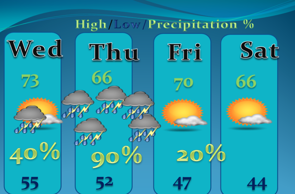
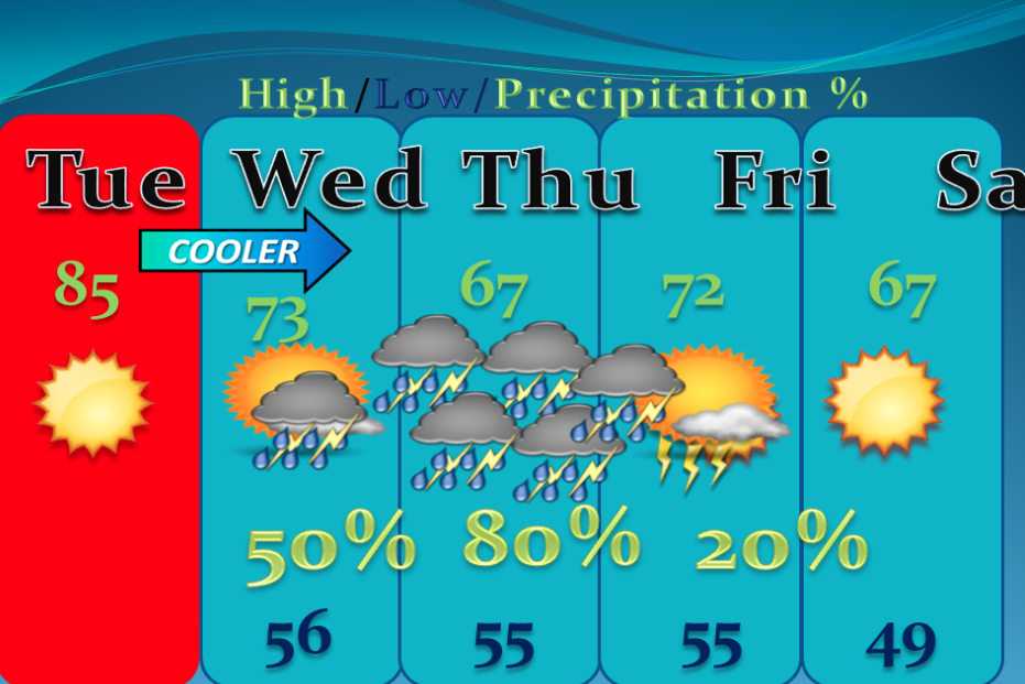
A storm system moving though the desert southwest will provide the energy and moisture for scattered showers and isolated thunderstorms on Wednesday. However, widespread rainfall and scattered thunderstorm are likely on Thursday, lasting through the entire day and into Thursday night into central Kansas. One or two inches of rain will fall by the time the precipitation ends.

Today Sunny, with a high near 86. South southwest wind 9 to 17 mph.

Tonight A 20 percent chance of showers and thunderstorms after midnight. Partly cloudy, with a low around 56. South wind 9 to 16 Screen Shot 2015-10-20 at 5.26.17 AMmph.

WednesdayA 40 percent chance of showers and thunderstorms. Mostly cloudy, with a high near 70. North northwest wind 6 to 16 mph becoming northeast in the afternoon.

Wednesday NightA chance of showers and thunderstorms, then showers likely and possibly a thunderstorm after 2am. Cloudy, with a low around 55. East wind 11 to 15 mph. Chance of precipitation is 60%. New rainfall amounts between a tenth and quarter of an inch, except higher amounts possible in thunderstorms.

ThursdayShowers likely and possibly a thunderstorm. Cloudy, with a high near 67. Breezy, with an east wind 10 to 15 mph increasing to 16 to 21 mph in the afternoon. Chance of precipitation is 70%. New rainfall amounts between three quarters and one inch possible.

Thursday NightA 50 percent chance of showers and thunderstorms. Cloudy, with a low around 55.

FridayA 20 percent chance of showers and thunderstorms. Mostly sunny, with a high near 72.

Friday NightA 20 percent chance of showers and thunderstorms. Mostly clear, with a low around 48.

SaturdayMostly sunny, with a high near 65.
Copyright Eagle Radio | FCC Public Files | EEO Public File