We have a brand new updated website! Click here to check it out!

Sunny, warmer Wednesday


Fall weather and temperatures will continue for the next few days.

Today Mostly sunny, with a high near 72. Light and variable wind becoming southeast 5 to 10 mph in the morning.
Screen Shot 2015-09-30 at 5.38.03 AMTonight A 20 percent chance of showers and thunderstorms after 11pm. Mostly cloudy, with a low around 53. East southeast wind around 9 mph.

ThursdayA 20 percent chance of showers and thunderstorms. Mostly cloudy, with a high near 66. East southeast wind around 9 mph.

Thursday NightA 20 percent chance of showers and thunderstorms after 1am. Mostly cloudy, with a low around 48. East southeast wind 7 to 10 mph.

FridayA 20 percent chance of showers and thunderstorms. Mostly cloudy, with a high near 58. Southeast wind around 10 mph.

Friday NightA 50 percent chance of showers and thunderstorms. Mostly cloudy, with a low around 46.

SaturdayShowers likely and possibly a thunderstorm. Cloudy, with a high near 56. Chance of precipitation is 60%. New rainfall amounts between a tenth and quarter of an inch, except higher amounts possible in thunderstorms.
Cooler Tuesday and a chance for showers


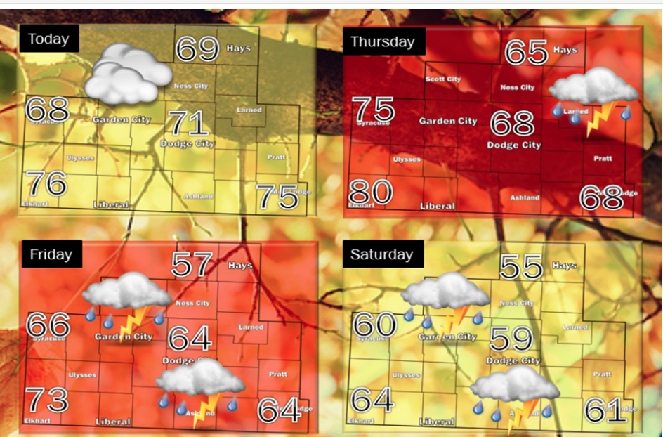
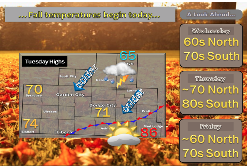
Good news for those who like cooler temperatures. Much cooler weather is expected over the next few days…particularly across the Interstate 70 corridor

Screen Shot 2015-09-29 at 5.43.41 AMToday Scattered showers and thunderstorms. Increasing clouds, with a high near 65. Northeast wind 6 to 15 mph. Chance of precipitation is 40%.

Tonight A 40 percent chance of showers and thunderstorms. Mostly cloudy, with a low around 55. East wind 6 to 11 mph.

WednesdayA 30 percent chance of showers and thunderstorms, mainly before 9am. Mostly cloudy, with a high near 68. Southeast wind 8 to 13 mph.

Wednesday NightA 20 percent chance of showers and thunderstorms after 10pm. Mostly cloudy, with a low around 54. East southeast wind around 9 mph.

ThursdayA 30 percent chance of showers and thunderstorms, mainly after 10am. Mostly cloudy, with a high near 69.

Thursday NightA 30 percent chance of showers and thunderstorms, mainly before midnight. Mostly cloudy, with a low around 51.

FridayA 40 percent chance of showers and thunderstorms. Mostly cloudy, with a high near 61.

Friday NightShowers likely. Cloudy, with a low around 45. Chance of precipitation is 60%. New precipitation amounts between a tenth and quarter of an inch possible.

SaturdayA 50 percent chance of showers. Cloudy, with a high near 57.

Sunny, hot Monday


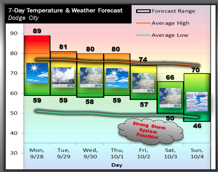
A very warm day is in store across western Kansas today. A cold front will approach late tonight into Tuesday before stalling out. There will likely be a fairly sharp temperature gradient across the Central Plains Tuesday and Wednesday. Dodge City should be on the warm side of the front through Wednesday, but the cooler air will gain momentum by the end of the week. A fairly strong storm will likely cross the Rockies late in the week leading to a favorable environment for an organized precipitation event across the Central Plains, including southwest Kansas

Screen Shot 2015-09-28 at 5.31.25 AMToday Sunny, with a high near 89. South wind 6 to 13 mph.

Tonight A 20 percent chance of showers and thunderstorms after 3am. Partly cloudy, with a low around 59. South southeast wind 8 to 10 mph.

TuesdayA 40 percent chance of showers and thunderstorms. Mostly cloudy, with a high near 73. East northeast wind 7 to 14 mph.

Tuesday NightA 30 percent chance of showers and thunderstorms, mainly before 1am. Mostly cloudy, with a low around 57. East northeast wind 9 to 14 mph.

WednesdayA 40 percent chance of showers and thunderstorms, mainly after 8am. Mostly cloudy, with a high near 76. South southeast wind 9 to 15 mph.

Wednesday NightA 20 percent chance of showers and thunderstorms before 10pm. Partly cloudy, with a low around 58.

ThursdayPartly sunny, with a high near 77.

Cloudy, cool Friday and chance for thunderstorms


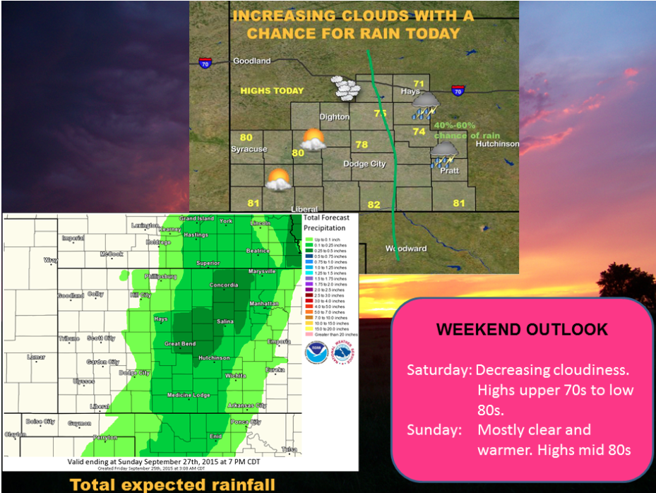
Cloudiness will increase in central and northern Kansas this morning and across much of western Kansas tonight as an upper level low moves from Nebraska into northern Kansas. Showers and a few thunderstorms will develop in central Kansas by early afternoon and spread into southern Kansas by evening.

Screen Shot 2015-09-25 at 5.45.51 AMToday A chance of showers and thunderstorms, then showers likely and possibly a thunderstorm after 4pm. Patchy fog before 10am. Otherwise, mostly cloudy, with a high near 72. Northwest wind 6 to 9 mph. Chance of precipitation is 60%. New rainfall amounts of less than a tenth of an inch, except higher amounts possible in thunderstorms.
Tonight A 40 percent chance of showers and thunderstorms, mainly before 11pm. Patchy fog after 4am. Otherwise, mostly cloudy, with a low around 57. Northeast wind 5 to 9 mph.

SaturdayPatchy fog before 9am. Otherwise, mostly sunny, with a high near 82. Northeast wind 5 to 10 mph becoming east southeast in the afternoon.

Saturday NightMostly clear, with a low around 56. East southeast wind 6 to 9 mph.

SundaySunny, with a high near 87. South wind 7 to 14 mph.

Sunday NightMostly clear, with a low around 61.

MondaySunny, with a high near 88.

Partly sunny, chance for thunderstorms

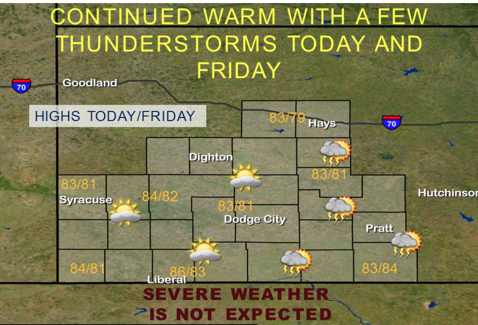
A weak upper level low centered in Nebraska will wallow across Kansas into northwest Oklahoma by Friday evening. Scattered showers and thunderstorms can be expected across central and south central Kansas both today and Friday. Temperatures will be mild with highs from the upper 70s to the mid 80s.

Screen Shot 2015-09-24 at 5.38.05 AMToday Isolated showers and thunderstorms. Partly sunny, with a high near 83. South wind 9 to 13 mph becoming northwest in the afternoon. Chance of precipitation is 20%.

TonightA 30 percent chance of showers and thunderstorms, mainly before 8pm. Mostly cloudy, with a low around 60. North wind 5 to 9 mph becoming calm.

FridayA 20 percent chance of showers and thunderstorms after 11am. Partly sunny, with a high near 80. North northwest wind around 6 mph becoming east in the afternoon.

Friday NightPartly cloudy, with a low around 58. East wind 3 to 7 mph.

SaturdayMostly sunny, with a high near 84.

Saturday NightMostly clear, with a low around 59.

SundaySunny, with a high near 88.

Sunday NightMostly clear, with a low around 61.

MondaySunny, with a high near 90.

Wet, windy Wednesday

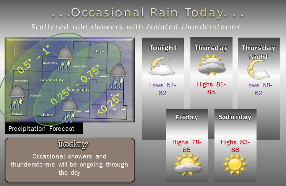
Occasional showers and thunderstorms will be ongoing through the day. A northeast to southwest oriented broken band of showers will slowly move from west to east. It is likely the shower band will be east of the highway 283 corridor (or roughly a Screen Shot 2015-09-23 at 5.48.22 AMWakeeney to Minneola line by around 1 pm. Most of the precipitation should be east of the Stafford to Medicine Lodge corridor by the end of the afternoon. The highest concentration of light to moderate intensity rain shower coverage will be found across west central Kansas, primarily west of a Hays to Ashland line. Rain cooled air will rebound into the upper 70s and low 80s by mid afternoon as the precipitation moves east. Warmer highs in the middle 80s are likely around Stafford, Pratt and Medicine Lodge. For Tonight, leftover surface moisture from earlier rains will help promote patchy fog west of highway 283, however moderate winds will be just strong enough to likely prevent any the fog from becoming widespread. Temperatures will cool to the upper 50s west and low 60s in central Kansas. For the remainder of the week, dry conditions and warmer temperatures are forecast slightly warmer than normal for late September. Temperatures are forecast to be even warmer on Sunday and Monday, in the upper 80s.

Today Showers likely and possibly a thunderstorm before 1pm, then a chance of showers and thunderstorms after 1pm. Mostly cloudy, with a high near 82. Breezy, with a south wind 9 to 14 mph increasing to 17 to 22 mph in the afternoon. Chance of precipitation is 60%. New rainfall amounts between a quarter and half of an inch possible.

 Tonight A 50 percent chance of showers and thunderstorms. Mostly cloudy, with a low around 63. Breezy, with a south wind 13 to 20 mph.

ThursdayA 30 percent chance of showers and thunderstorms, mainly before 8am. Partly sunny, with a high near 82. South wind 11 to 13 mph.

Thursday NightA 20 percent chance of showers and thunderstorms. Mostly cloudy, with a low around 59. East northeast wind 7 to 11 mph.

FridayA 20 percent chance of showers and thunderstorms. Partly sunny, with a high near 80.

Friday NightA 20 percent chance of showers and thunderstorms before 8pm. Partly cloudy, with a low around 57.

SaturdaySunny, with a high near 84.

Toasty Tuesday and a chance of overnight storms

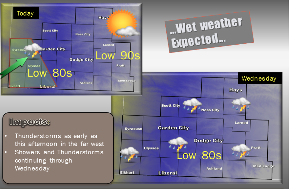
Screen Shot 2015-09-22 at 5.17.15 AMA chance for showers and isolated thunderstorms returns by late this afternoon through the overnight across far west central and southwest Kansas. No severe weather is expected, so the only real threat will be isolated lightning. Increasing clouds in the western sections will hold temperatures down in the upper 70 to lows Today. Farther east, highs will rise to around 90s degrees in central Kansas. High and mid level moisture will continue to feed into the Central Plains from the southwest United States overnight into Wednesday. Most of the area should see variable amounts of rain on Wednesday as scattered showers and isolated thunderstorms continue on and off during the day. Rainfall amounts could easily vary between a tenth and more than three quarters of an inch. Again, severe storms are not likely and lightning will be the main threat. Temperatures are forecast around 10 degrees cooler for Wednesday afternoon.

Today Mostly sunny, with a high near 94. South wind 8 to 16 mph.

Tonight A 20 percent chance of showers and thunderstorms after 3am. Mostly cloudy, with a low around 66. South wind 10 to 15 mph.

WednesdayA 40 percent chance of showers and thunderstorms. Mostly cloudy, with a high near 82. Breezy, with a south wind 10 to 15 mph increasing to 17 to 22 mph in the afternoon.

Wednesday NightA 50 percent chance of showers and thunderstorms. Mostly cloudy, with a low around 62. Breezy, with a south wind 13 to 21 mph.

ThursdayA 30 percent chance of showers and thunderstorms. Partly sunny, with a high near 80. South wind 11 to 13 mph.

Thursday NightA 30 percent chance of showers and thunderstorms, mainly before 8pm. Mostly cloudy, with a low around 59.

FridayA 20 percent chance of showers and thunderstorms. Partly sunny, with a high near 79.

Friday NightA 20 percent chance of showers and thunderstorms before 8pm. Partly cloudy, with a low around 58.

SaturdaySunny, with a high near 84.

Partly sunny, warmer Monday


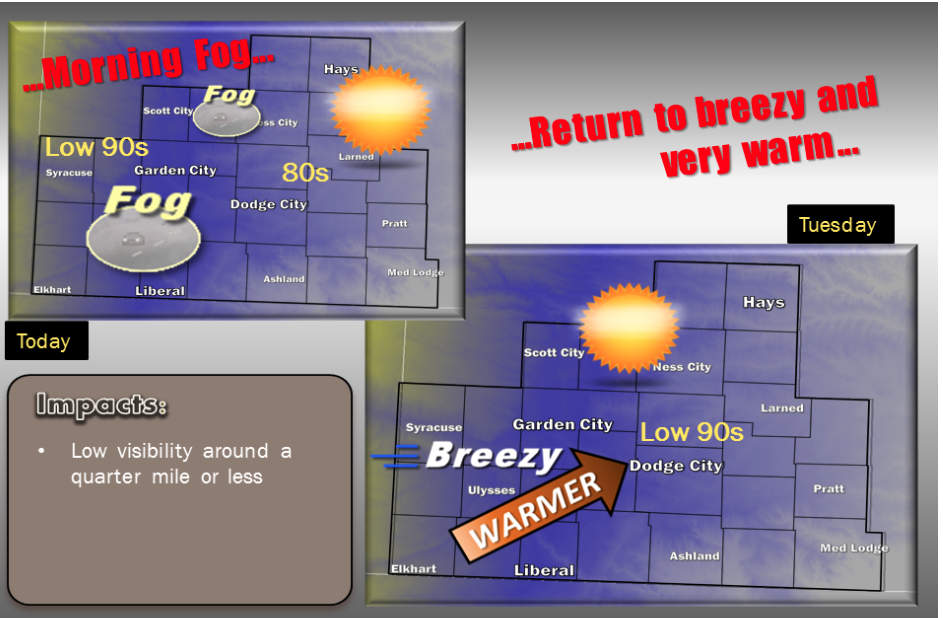
Dense fog will likely expand across sections of west central and southwest Kansas on Monday morning. Locations from Ulysses to Garden City, Scott City and Ness City may be the most favored areas for dense fog. If the fog expands across a large enough area, it could linger through the mid to late morning hours. Temperatures today will be influenced by lingering low level clouds over central Kansas. As a result, highs in the more sunny west should easily reach the 90s, while farther east, only the low 80s. Lows tonight will once again be mild, in the mid 60s, however fog will not be as likely. By Tuesday, breezy winds and full sun will return with warm low 90s overspreading the entire area. Temperatures will be slightly cooler by Wednesday and into Thursday as a subtropical jet arrives bringing increased clouds followed chances for widespread showers and scattered thunderstorms to the Central Plains.

Screen Shot 2015-09-21 at 5.25.26 AMToday Areas of fog before 8am. Otherwise, cloudy through mid morning, then gradual clearing, with a high near 82. South wind 6 to 14 mph.

Tonight Mostly clear, with a low around 63. South southeast wind 7 to 13 mph.

Tuesday Sunny, with a high near 92. South wind 10 to 17 mph.

Tuesday NightA 20 percent chance of showers and thunderstorms after 3am. Partly cloudy, with a low around 66. South wind 11 to 17 mph.

WednesdayA 40 percent chance of showers and thunderstorms, mainly after 7am. Mostly cloudy, with a high near 86. Breezy, with a south wind 14 to 22 mph.

Wednesday NightA 50 percent chance of showers and thunderstorms. Mostly cloudy, with a low around 63. Breezy.

ThursdayA 40 percent chance of showers and thunderstorms. Partly sunny, with a high near 82.

Thursday NightA 40 percent chance of showers and thunderstorms. Mostly cloudy, with a low around 60.

FridayMostly sunny, with a high near 81.

Cloudy, cooler Friday


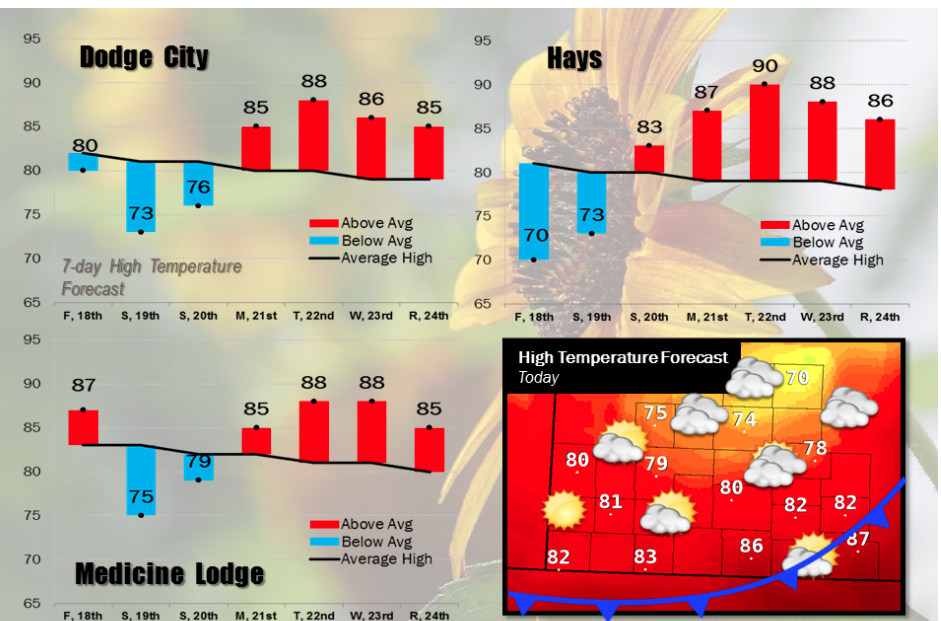
A fairly strong cold front will be pushing through southwest Kansas today. Much cooler temperatures will move in from the north, along with low clouds. The extensive low cloud cover will keep temperatures in the 60s to lower 70s across much of northern and central Kansas, including Wakeeney and Hays, where highs will only be around 70. Ahead of the front in far south central Kansas, afternoon temperatures will top out in the upper 80s. Strong to severe thunderstorms will develop along the front, but should remain southeast of our region, including Barber County. Below average temperatures will occur Saturday and Sunday with temperatures warming back up above average next week.

Screen Shot 2015-09-18 at 5.18.35 AMToday Mostly cloudy, with a high near 73. East northeast wind 14 to 17 mph becoming north in the afternoon.

Tonight Mostly cloudy, then gradually becoming mostly clear, with a low around 50. North wind 8 to 18 mph, with gusts as high as 28 mph.

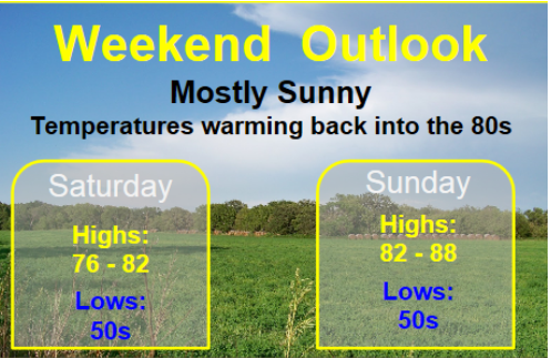
SaturdayMostly sunny, with a high near 80. North wind 6 to 9 mph becoming east southeast in the afternoon.

Saturday NightA 20 percent chance of showers and thunderstorms after 4am. Partly cloudy, with a low around 54. East southeast wind 7 to 10 mph.

SundayA 30 percent chance of showers and thunderstorms, mainly after 8am. Mostly sunny, with a high near 83. South wind 7 to 11 mph.

Sunday NightA 30 percent chance of showers and thunderstorms before 8pm. Mostly clear, with a low around 55.

MondaySunny, with a high near 86.

Hot, windy Thursday


Today will be the final day of well-above average, hot weather across southwest Kansas. A cold front will push south today, but its refreshing effects will not be felt until this weekend. Expect some isolated to widely scattered thunderstorms to form along the front late this afternoon and again Friday afternoon, but the best chance will be across central and south central Kansas.

Screen Shot 2015-09-17 at 5.39.36 AMToday Sunny, with a high near 93. South southwest wind 13 to 17 mph becoming north in the afternoon.

Tonight A 20 percent chance of showers and thunderstorms after midnight. Increasing clouds, with a low around 63. Northeast wind 11 to 16 mph.

FridayPartly sunny, with a high near 80. Northeast wind 14 to 18 mph, with gusts as high as 28 mph.

Friday NightMostly clear, with a low around 50. North northeast wind 8 to 17 mph.

SaturdaySunny, with a high near 76. North wind 6 to 9 mph becoming east southeast in the afternoon.

Saturday NightA 20 percent chance of showers and thunderstorms after 3am. Partly cloudy, with a low around 51.

SundayA 30 percent chance of showers and thunderstorms, mainly after 8am. Mostly sunny, with a high near 80.

Hot, windy Tuesday with a chance for thunderstorms


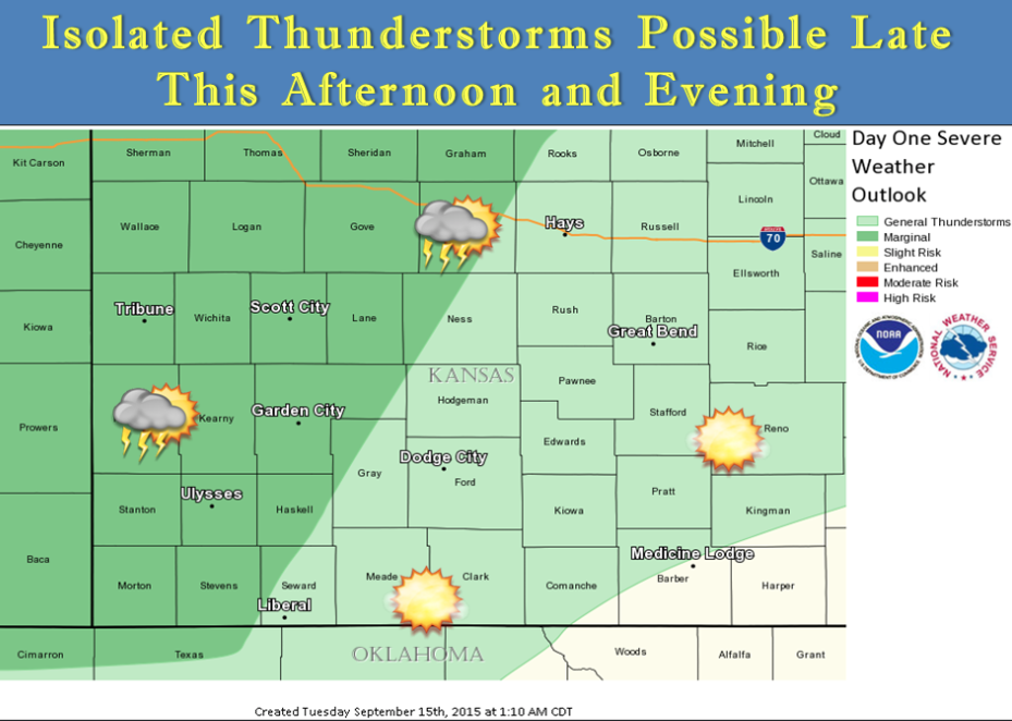
Isolated strong to marginally severe thunderstorms are possible across west central and southwest Kansas late this afternoon and evening. The potential exists for up to nickel size hail and gusty winds in excess of 60 mph.

Screen Shot 2015-09-15 at 5.44.44 AMToday Sunny, with a high near 97. Very windy, with a south southwest wind 15 to 20 mph increasing to 25 to 30 mph in the afternoon.

Tonight A 20 percent chance of showers and thunderstorms after 11pm. Mostly cloudy, with a low around 70. Windy, with a south wind 17 to 25 mph.

WednesdaySunny, with a high near 95. Breezy, with a south wind 14 to 21 mph.

Wednesday NightMostly clear, with a low around 70. Breezy, with a south wind 16 to 22 mph.

ThursdaySunny, with a high near 94. Southwest wind 6 to 13 mph becoming north in the afternoon.

Thursday NightA 20 percent chance of showers and thunderstorms. Partly cloudy, with a low around 64.

FridayMostly sunny, with a high near 81. Breezy.

Friday NightMostly clear, with a low around 50.

SaturdaySunny, with a high near 79.

Sunny, cooler Friday


Today
Mostly sunny, with a high near 75. North wind 9 to 14 mph.
Screen Shot 2015-09-11 at 5.55.05 AM

Tonight Partly cloudy, with a low around 51. Northeast wind 5 to 11 mph becoming southeast after midnight.

SaturdayMostly sunny, with a high near 78. South wind 5 to 14 mph.

Saturday NightMostly clear, with a low around 53. South southeast wind 9 to 14 mph.

SundaySunny, with a high near 85. Breezy, with a south wind 9 to 14 mph increasing to 16 to 21 mph in the afternoon.

Sunday NightMostly clear, with a low around 62.

MondaySunny, with a high near 91. Breezy

Partly sunny, chance for Thursday thunderstorms


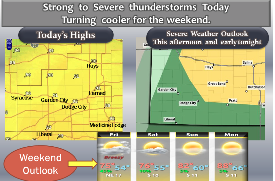
It will be warm with a chance of severe thunderstorms this afternoon and early tonight. Turning cooler for the weekend.

Today A 30 percent chance of showers and thunderstorms, mainly after 3pm. Partly sunny, with a high near 90. South wind 5 to Screen Shot 2015-09-10 at 5.49.19 AM9 mph.
Tonight A 40 percent chance of showers and thunderstorms, mainly before 5am. Mostly cloudy, with a low around 57. Northeast wind 10 to 13 mph.

FridayA slight chance of showers and thunderstorms before 7am, then a slight chance of showers between 7am and 9am. Mostly sunny, with a high near 76. Northeast wind 11 to 15 mph. Chance of precipitation is 20%.

Friday NightPartly cloudy, with a low around 53. East southeast wind 7 to 13 mph.

SaturdayMostly sunny, with a high near 76.

Saturday NightPartly cloudy, with a low around 54.

SundaySunny, with a high near 85.

Sunday NightMostly clear, with a low around 61.

MondaySunny, with a high near 91.

Copyright Eagle Radio | FCC Public Files | EEO Public File