We have a brand new updated website! Click here to check it out!

Sunny, warmer Wednesday


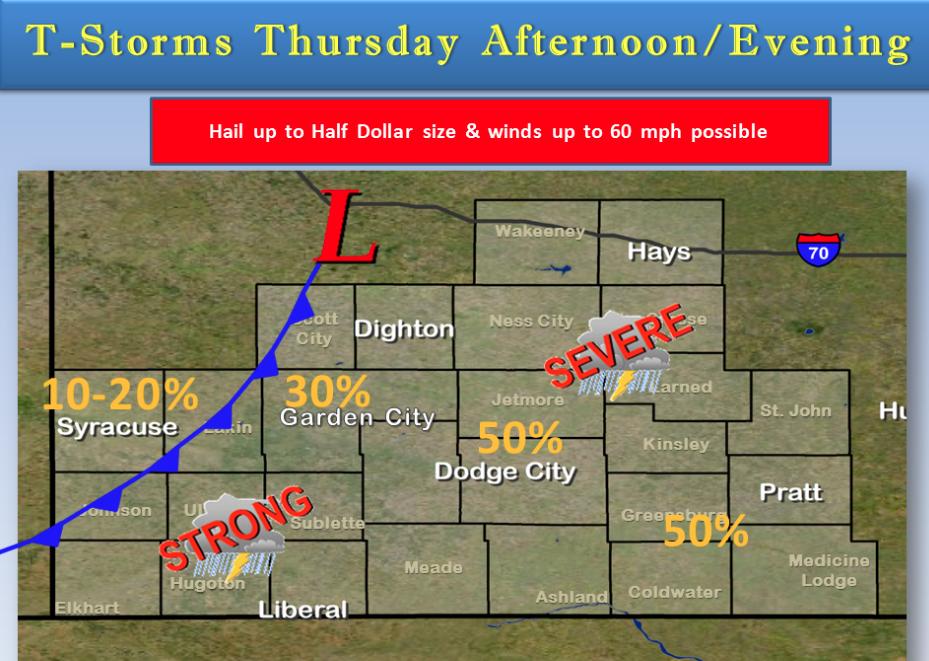
There is a chance of thunderstorms Thursday afternoon and evening. Some of these storms could be severe with hail as large as half dollars and wind gusts as high as 60 mph. The best chance of severe storms is along and east of a line from Scott City to Garden City to Liberal. High temperatures will be in the upper 80s to lower 90s. Cooler weather is on the way for Friday in the wake of the cold front.

Today Patchy fog before 10am. Otherwise, mostly sunny, with a high near 87. Light and variable wind becoming south Screen Shot 2015-09-09 at 6.27.18 AMsoutheast 5 to 9 mph in the morning.

Tonight A 20 percent chance of showers and thunderstorms after 4am. Partly cloudy, with a low around 61. South southeast wind 7 to 10 mph.

ThursdayA 30 percent chance of showers and thunderstorms, mainly after 2pm. Mostly sunny, with a high near 90. South southwest wind 7 to 11 mph.

Thursday NightA 30 percent chance of showers and thunderstorms, mainly before 5am. Mostly cloudy, with a low around 59. East wind around 11 mph becoming north northeast after midnight.

FridayA 10 percent chance of showers and thunderstorms before 7am. Partly sunny, with a high near 76. Northeast wind 11 to 15 mph.

Friday NightMostly cloudy, with a low around 53.

SaturdayMostly sunny, with a high near 77.
Cloudy, cooler Tuesday


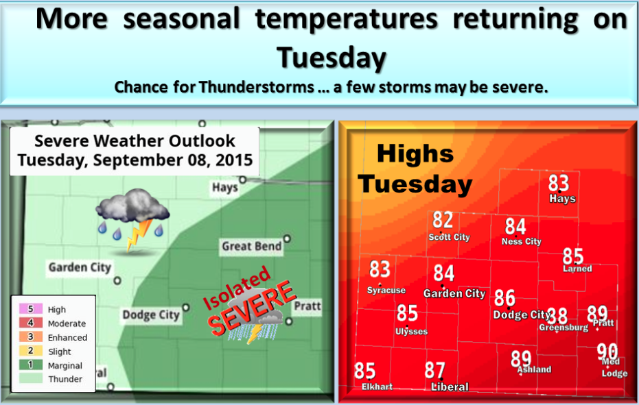
Tuesday will be cooler with a chance for strong to marginally severe thunderstorms possible late day.

Screen Shot 2015-09-08 at 5.43.03 AMToday A 30 percent chance of showers and thunderstorms, mainly before 10am. Mostly cloudy, with a high near 84. North wind 7 to 11 mph.
Tonight Partly cloudy, with a low around 61. Northeast wind 6 to 10 mph.

WednesdayMostly sunny, with a high near 84. Northeast wind 5 to 9 mph becoming southeast in the afternoon.

Wednesday NightPartly cloudy, with a low around 61. Southeast wind 7 to 11 mph.

ThursdayA 30 percent chance of showers and thunderstorms, mainly after noon. Mostly sunny, with a high near 89.

Thursday NightA 40 percent chance of showers and thunderstorms. Mostly cloudy, with a low around 59.

FridayA 20 percent chance of showers and thunderstorms. Mostly sunny, with a high near 79.

Friday NightA 20 percent chance of showers and thunderstorms. Mostly cloudy, with a low around 55.

SaturdayA 20 percent chance of showers and thunderstorms. Partly sunny, with a high near 77.
Hot, windy Thursday


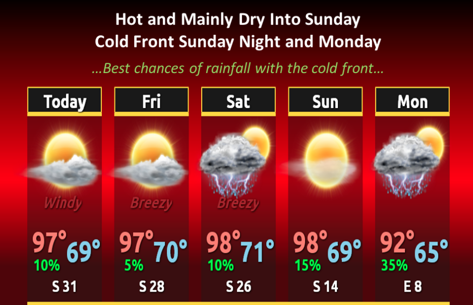
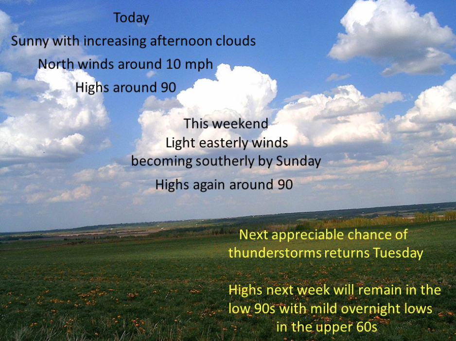
Continued hot and mainly dry into Sunday, then a cold front will bring the best chances for showers and thunderstorms on Sunday night into Monday. Our average highs for this time of year are in the mid to upper 80s, with lows around 60.

Screen Shot 2015-09-03 at 4.59.57 AMToday Mostly sunny, with a high near 99. Windy, with a south wind 8 to 13 mph increasing to 20 to 25 mph in the afternoon.

Tonight Partly cloudy, with a low around 71. Breezy, with a south wind 15 to 21 mph.

FridayMostly sunny, with a high near 98. Breezy, with a south wind 14 to 23 mph.

Friday NightPartly cloudy, with a low around 72. Breezy, with a south wind 13 to 20 mph.

SaturdayMostly sunny, with a high near 98. Breezy, with a south wind 11 to 16 mph increasing to 17 to 22 mph in the afternoon.

Saturday NightIsolated thunderstorms before 7pm. Partly cloudy, with a low around 73. Chance of precipitation is 10%.

SundayIsolated thunderstorms after 3pm. Sunny, with a high near 97. Little or no precipitation expected.

Sunday NightIsolated thunderstorms before 7pm. Mostly clear, with a low around 67. Chance of precipitation is 10%.

Labor DayA 30 percent chance of showers and thunderstorms. Mostly sunny, with a high near 90.

Hot, breezy Wednesday


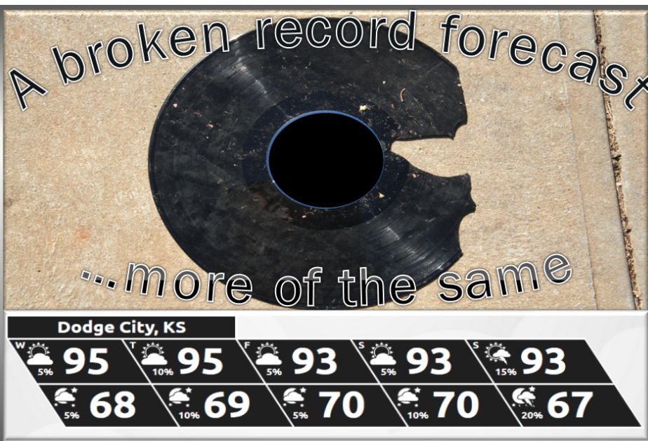
Take todays weather and multiply by 5 days. Sounds like a broken record.

Screen Shot 2015-09-02 at 4.55.32 AMWednesday Sunny, with a high near 99. South wind 8 to 18 mph.
Wednesday Night Partly cloudy, with a low around 69. Breezy, with a south wind 14 to 22 mph.

ThursdayMostly sunny, with a high near 96. Breezy, with a south wind 13 to 20 mph.

Thursday NightA 20 percent chance of showers and thunderstorms before 8pm. Partly cloudy, with a low around 71. Breezy, with a south wind 13 to 21 mph.

FridayMostly sunny, with a high near 96. Breezy.

Friday NightPartly cloudy, with a low around 71. Breezy.

SaturdayMostly sunny, with a high near 95. Breezy.

Saturday NightPartly cloudy, with a low around 72.

SundayA 20 percent chance of showers and thunderstorms. Mostly sunny, with a high near 96.

Toasty Tuesday, chance of overnight showers


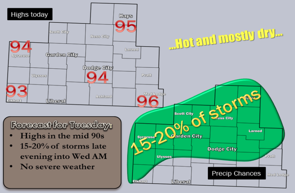
Tuesday will be toasty and mostly dry

Screen Shot 2015-09-01 at 5.27.13 AMTodayMostly sunny, with a high near 96. South wind 9 to 17 mph.

TonightA 20 percent chance of showers and thunderstorms after midnight. Partly cloudy, with a low around 69. Breezy, with a south wind 14 to 21 mph.

WednesdayMostly sunny, with a high near 97. Windy, with a south wind 13 to 18 mph increasing to 20 to 25 mph in the afternoon.

Wednesday NightPartly cloudy, with a low around 70. Breezy, with a south wind 14 to 22 mph.

ThursdayMostly sunny, with a high near 97. South wind 13 to 18 mph, with gusts as high as 28 mph.

Thursday NightA 20 percent chance of showers and thunderstorms. Partly cloudy, with a low around 71. Breezy.

FridayA 20 percent chance of showers and thunderstorms. Mostly sunny, with a high near 95. Breezy.

Friday NightPartly cloudy, with a low around 71. Breezy.

SaturdayA 20 percent chance of showers and thunderstorms. Mostly sunny, with a high near 94. Breezy.

Sunny, hot Friday


Our area will be under the influence of light northerly winds behind the surface front that brought last evenings storms. Sunny skies through most of the day will give way to some fair weather cloud development by the afternoon. Temperatures this afternoon and Saturday will reach the upper 80s to around 90 degrees with light winds through the period. Following a couple of days in the upper 80s to around 90 degrees, temperatures will trend slightly warmer than normal into next week.

Screen Shot 2015-08-28 at 5.28.41 AMToday Mostly sunny, with a high near 89. West wind 7 to 11 mph becoming north in the afternoon.

Tonight Mostly clear, with a low around 60. North northeast wind 6 to 11 mph.

Saturday Sunny, with a high near 90. North northeast wind 6 to 8 mph.

Saturday NightMostly clear, with a low around 60. East southeast wind 5 to 9 mph.

SundaySunny, with a high near 92. South southeast wind 6 to 14 mph.

Sunday NightMostly clear, with a low around 65.

MondaySunny, with a high near 94.

Monday NightPartly cloudy, with a low around 69.

Partly sunny, chance of Thunderstorms

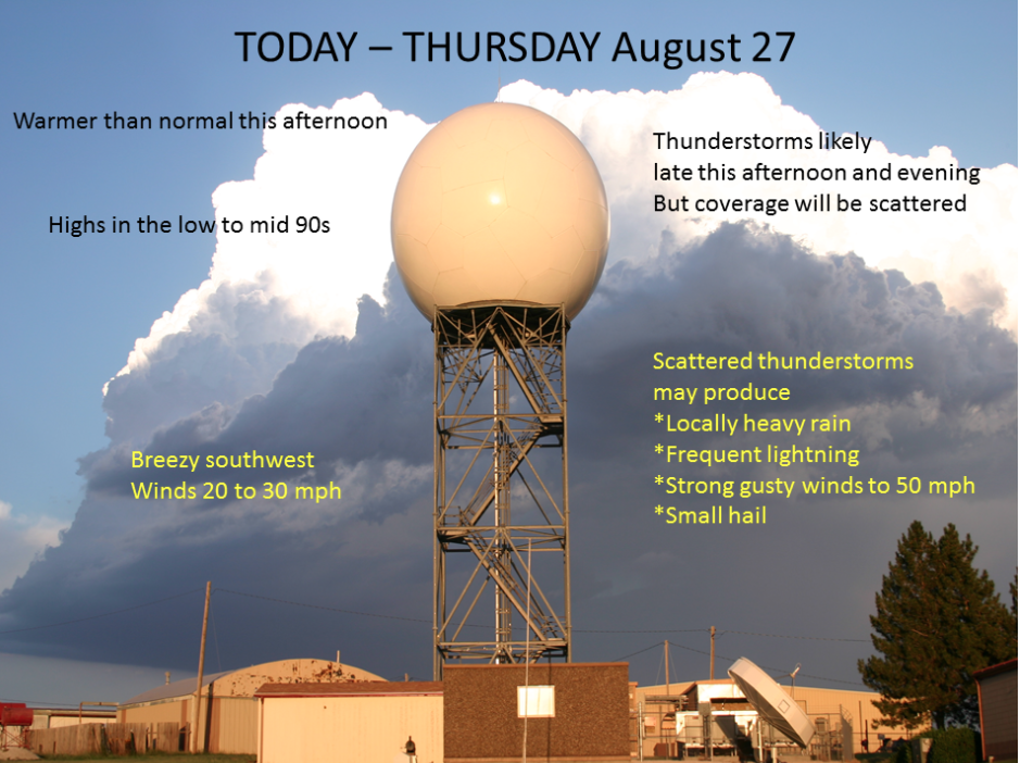
Warm temperatures return this afternoon on breezy southwest winds of 20 to 30 mph. Highs are forecast to reach the mid 90s. By late in the afternoon, clouds will be increasing as a surface cold front moves through northwest Kansas and into central Kansas by the early evening. The location of the surface front will be the focus area for scattered thunderstorms development, probably somewhere south of I-70 near Hays southwest to around Hugoton. Some of the storms may initially become strong enough to produce small hail and wind gusts around 50 mph. Although an isolated severe storm with larger hail and stronger wind is possible, widespread severe weather is not expected. Any storms that do develop will move southward into central Kansas, diminishing after midnight. Slightly cooler highs in the upper 80s are expected Friday before a gradual warming trend into the 90s resumes this weekend.

Screen Shot 2015-08-27 at 5.15.59 AMToday A 40 percent chance of showers and thunderstorms, mainly after 3pm. Partly sunny, with a high near 96. South southwest wind 7 to 12 mph increasing to 13 to 18 mph in the afternoon. Winds could gust as high as 28 mph.

Tonight Showers and thunderstorms likely, mainly before 9pm. Mostly cloudy, with a low around 65. South southwest wind 10 to 18 mph. Chance of precipitation is 60%. New rainfall amounts between a quarter and half of an inch possible.

FridayMostly sunny, with a high near 88. West wind 10 to 13 mph becoming north in the afternoon.

Friday NightMostly clear, with a low around 62. North wind 5 to 11 mph.

SaturdaySunny, with a high near 89. North northeast wind 6 to 8 mph becoming east in the afternoon.

Saturday NightMostly clear, with a low around 62.

SundaySunny, with a high near 93.

Sunny, hot Wednesday


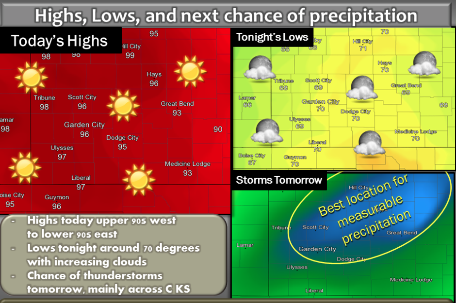
Highs today look to top out in the 90s with lows tonight around 70 degrees. Thunderstorms are possible tomorrow, with the best chance across central Kansas.

Screen Shot 2015-08-26 at 5.55.36 AMToday Sunny, with a high near 97. South southeast wind 6 to 14 mph.

Tonight Partly cloudy, with a low around 70. South wind 11 to 15 mph.

ThursdayA 30 percent chance of showers and thunderstorms, mainly after 3pm. Partly sunny, with a high near 94. Breezy, with a south wind 11 to 16 mph increasing to 19 to 24 mph in the afternoon.

Thursday NightA 50 percent chance of showers and thunderstorms, mainly before 4am. Mostly cloudy, with a low around 65.

South wind 10 to 18 mph becoming west southwest after midnight.

FridayMostly sunny, with a high near 86. Northwest wind 11 to 17 mph.

Friday NightMostly clear, with a low around 60.


SaturdaySunny, with a high near 86.

Sunny, warmer Tuesday


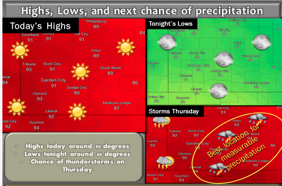
Highs around 90 degrees today with lows around 60 degrees tonight. Next chance of thunderstorms on Thursday

Screen Shot 2015-08-25 at 5.19.15 AMToday Sunny, with a high near 89. Light south wind becoming south southeast 8 to 13 mph in the morning.

TonightMostly clear, with a low around 61. South southeast wind 8 to 11 mph.

WednesdayMostly sunny, with a high near 93. South southeast wind 7 to 15 mph.

Wednesday NightPartly cloudy, with a low around 70. South southeast wind 10 to 15 mph.

ThursdayA 50 percent chance of showers and thunderstorms, mainly after 10am. Partly sunny, with a high near 92. South wind 9 to 17 mph.

Thursday NightA 50 percent chance of showers and thunderstorms, mainly before 5am. Mostly cloudy, with a low around 66.

FridayA 20 percent chance of showers and thunderstorms before 9am. Mostly sunny, with a high near 85.

Friday NightMostly clear, with a low around 60.

SaturdaySunny, with a high near 85.

Sunny, warm Monday


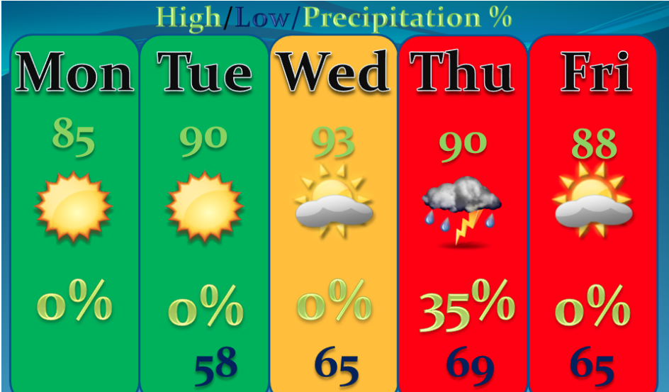
Highs increase a few degrees each day through mid-week then decrease a few degrees late week behind a cold front.

Screen Shot 2015-08-24 at 5.46.43 AMToday Sunny, with a high near 85. Light and variable wind becoming south 5 to 9 mph in the morning.

Tonight Mostly clear, with a low around 56. South southeast wind 7 to 9 mph.

TuesdaySunny, with a high near 90. South southeast wind 6 to 13 mph.

Tuesday NightPartly cloudy, with a low around 64. South southeast wind 8 to 11 mph.

WednesdayMostly sunny, with a high near 92. South southeast wind 7 to 14 mph.

Wednesday NightA 20 percent chance of showers and thunderstorms after 3am. Partly cloudy, with a low around 70.

ThursdayA 40 percent chance of showers and thunderstorms. Partly sunny, with a high near 90.

Thursday NightA 40 percent chance of showers and thunderstorms. Mostly cloudy, with a low around 66.

FridayMostly sunny, with a high near 87.

Sunny, warmer Friday with a chance for thunderstorms


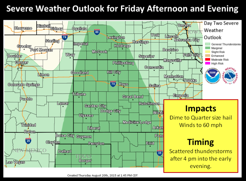
Widely scattered marginally severe thunderstorms are forecast to develop after 4 pm till around sunset on Friday with hail from dime to quarter size and winds of 50 to 60 mph. Most models indicate the area mainly near and east of Dodge City, if they develop.

Screen Shot 2015-08-21 at 5.25.27 AMToday Sunny, with a high near 89. Breezy, with a south wind 8 to 13 mph increasing to 18 to 23 mph in the afternoon.

Tonight Partly cloudy, with a low around 68. Breezy, with a south wind 15 to 21 mph.

SaturdayA 20 percent chance of showers and thunderstorms after 4pm. Mostly sunny, with a high near 95. Breezy, with a south wind 13 to 20 mph.

Saturday NightA 50 percent chance of showers and thunderstorms, mainly before 1am. Mostly cloudy, with a low around 59. West southwest wind 11 to 15 mph becoming north northeast after midnight.

SundaySunny, with a high near 80. North northeast wind 9 to 14 mph.

Sunday NightMostly clear, with a low around 56.

MondaySunny, with a high near 87.

Monday NightMostly clear, with a low around 62.

TuesdaySunny, with a high near 90.

Sunny, mild Thursday

Another pleasant day with highs in the mid 80s is in store for southwest Kansas. There will be a slight chance for thunderstorms mainly over central and south central Kansas Friday afternoon and across much of the area late Saturday as a cold front moves through the region. Cooler, fall-like weather is expected on Sunday.

Screen Shot 2015-08-20 at 5.42.53 AMToday Sunny, with a high near 87. Breezy, with a south wind 7 to 12 mph increasing to 15 to 20 mph in the afternoon.
Tonight Mostly clear, with a low around 63. South wind 13 to 17 mph.

FridayMostly sunny, with a high near 88. Breezy, with a south wind 9 to 14 mph increasing to 15 to 20 mph in the afternoon.

Friday NightA 20 percent chance of showers and thunderstorms before 2am. Partly cloudy, with a low around 69. South wind 13 to 17 mph.

SaturdayA 10 percent chance of showers and thunderstorms after 5pm. Mostly sunny, with a high near 94. South wind 13 to 16 mph.

Saturday NightA 50 percent chance of showers and thunderstorms, mainly before 2am. Mostly cloudy, with a low around 60.

SundayMostly sunny, with a high near 80.

Sunday NightMostly clear, with a low around 55.

MondaySunny, with a high near 86.

Partly sunny, cooler Wednesday


A few showers will linger across central and southwest Kansas early this morning. Meanwhile, much cooler air will filter southward into western Kansas today resulting in highs only up into the 70s under partly cloudy skies.

WednesdayA 20 percent chance of showers and thunderstorms before 9am. Mostly cloudy, then gradually becoming sunny, Screen Shot 2015-08-19 at 5.30.03 AMwith a high near 77. North northwest wind 10 to 15 mph.

Wednesday NightMostly clear, with a low around 50. North northwest wind 5 to 9 mph becoming calm.

ThursdaySunny, with a high near 86. South wind 5 to 10 mph increasing to 12 to 17 mph in the afternoon.

Thursday NightMostly clear, with a low around 62. South wind 10 to 17 mph.

FridayA 20 percent chance of showers and thunderstorms after 1pm. Mostly sunny, with a high near 88. Breezy.

Friday NightA 20 percent chance of showers and thunderstorms. Partly cloudy, with a low around 68. Breezy.

SaturdayA 20 percent chance of showers and thunderstorms. Mostly sunny, with a high near 92.

Saturday NightA 40 percent chance of showers and thunderstorms. Mostly cloudy, with a low around 62.

SundayMostly sunny, with a high near 81.

Sunday NightMostly clear, with a low around 58.


Copyright Eagle Radio | FCC Public Files | EEO Public File