We have a brand new updated website! Click here to check it out!

Windy, wet Tuesday


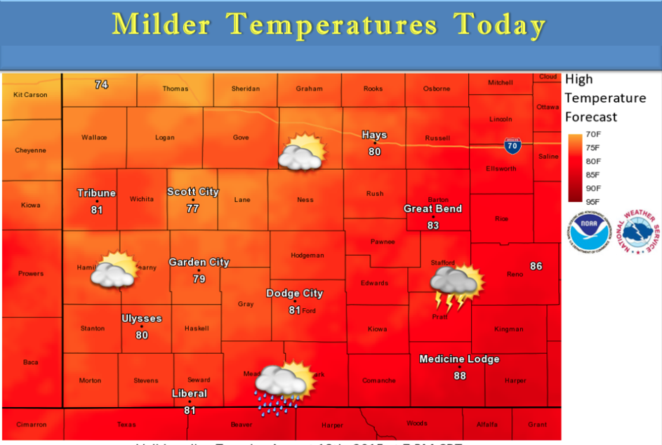
Isolated thunderstorms are possible late this afternoon into this evening across south central Kansas. Widespread severe weather is not expected. Look for highs generally up into the 80s.

Screen Shot 2015-08-18 at 5.53.40 AMTuesday Showers and thunderstorms likely, mainly before noon. Cloudy, then gradually becoming mostly sunny, with a high near 81. Breezy, with a south wind 8 to 13 mph becoming northwest 19 to 24 mph in the afternoon. Chance of precipitation is 60%. New rainfall amounts between a tenth and quarter of an inch, except higher amounts possible in thunderstorms.

Tuesday Night Mostly cloudy, with a low around 54. Breezy, with a north northwest wind 13 to 21 mph.

WednesdayMostly sunny, with a high near 76. Northwest wind around 10 mph.

Wednesday NightMostly clear, with a low around 54. North northwest wind 6 to 10 mph becoming south southwest after midnight.

ThursdaySunny, with a high near 84.

Thursday NightMostly clear, with a low around 64.

FridayA 20 percent chance of showers and thunderstorms. Mostly sunny, with a high near 89.

Friday NightA 20 percent chance of showers and thunderstorms. Partly cloudy, with a low around 69.

SaturdayMostly sunny, with a high near 93.
Partly cloudy, chance for thunderstorms


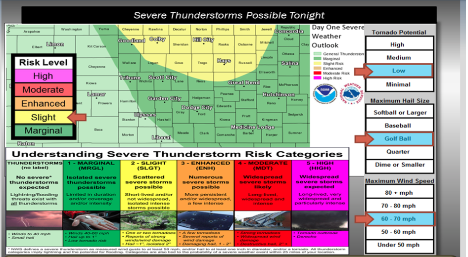
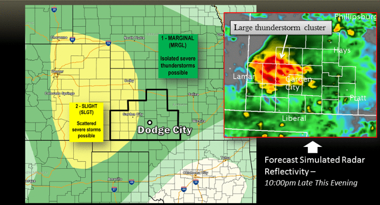
Slight Risk of severe thunderstorms late this afternoon and this evening across the High Plains.

Monday A 40 percent chance of showers and thunderstorms. Mostly cloudy, with a high near 87. South wind 6 to 11 mph.

Screen Shot 2015-08-17 at 6.50.56 AM
Monday Night
A 50 percent chance of showers and thunderstorms. Mostly cloudy, with a low around 65. South southeast wind 5 to 10 mph.

TuesdayA 50 percent chance of showers and thunderstorms. Mostly cloudy, with a high near 83. Light and variable wind becoming east northeast 5 to 9 mph in the morning.

Tuesday NightA 30 percent chance of showers and thunderstorms, mainly before 3am. Mostly cloudy, with a low around 55. North northwest wind 9 to 13 mph.

WednesdayA 10 percent chance of showers and thunderstorms before 7am. Mostly sunny, with a high near 75.

Wednesday NightMostly clear, with a low around 53.

ThursdaySunny, with a high near 84.

Thursday NightA 20 percent chance of showers and thunderstorms. Partly cloudy, with a low around 63.

FridayMostly sunny, with a high near 89.

Sunny, warmer Friday


Screen Shot 2015-08-14 at 5.48.11 AM

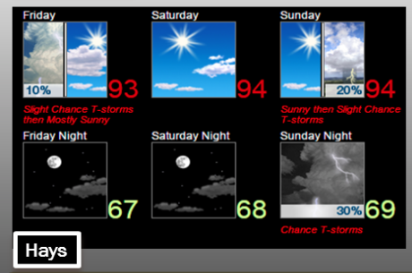
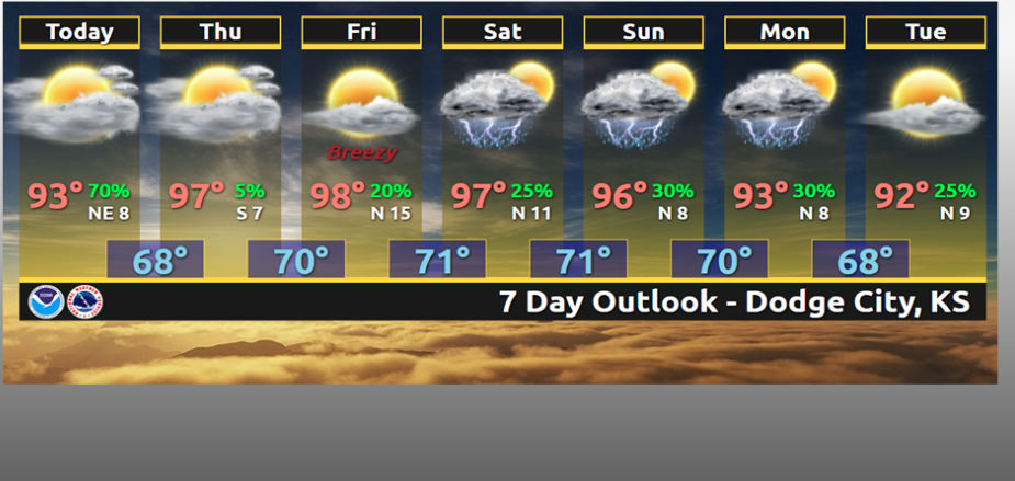
The weather over the weekend should be fairly tranquil and warm, with temperatures around the seasonal average of highs in the lower 90s. Precipitation chances will be fairly low through the weekend until late Sunday, when we will see an increase in chances as a cold front approaches western Kansas.

Today A 10 percent chance of showers and thunderstorms before 7am. Mostly sunny, with a high near 93. South wind 6 to 11 mph.

Tonight Mostly clear, with a low around 67. South southeast wind 8 to 11 mph.

Saturday Sunny, with a high near 94. South wind 8 to 14 mph.

Saturday Night Mostly clear, with a low around 69. South wind 10 to 15 mph.

Sunday A 20 percent chance of showers and thunderstorms after 3pm. Mostly sunny, with a high near 94.

Sunday Night A 30 percent chance of showers and thunderstorms. Mostly cloudy, with a low around 69.

Monday A 30 percent chance of showers and thunderstorms. Partly sunny, with a high near 91.

Monday Night A 30 percent chance of showers and thunderstorms. Mostly cloudy, with a low around 68.

Sunny, warmer Thursday

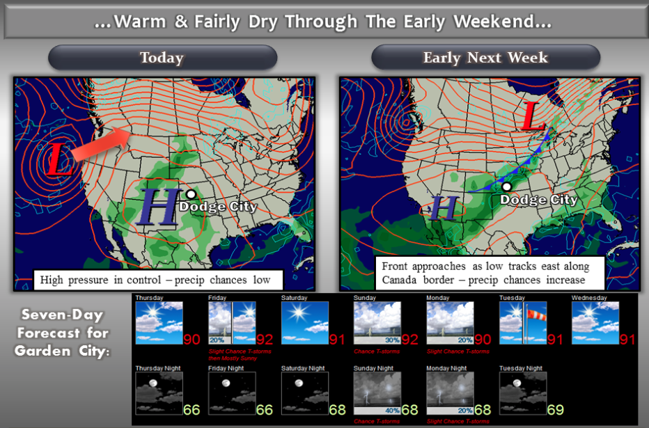
A large area of high pressure in the upper atmosphere will continue to influence our weather across western Kansas with hot and fairly dry conditions through the weekend. By late weekend into early next week, we will see our weather change as a cold front approaches. Precipitation chances will be on the increase Sunday Night into Monday as the front pushes through and interacts with some monsoon moisture from the southwest.

TodayMostly sunny, with a high near 90. South wind 6 to 14 mph.

Screen Shot 2015-08-13 at 5.32.38 AMTonightA 10 percent chance of showers and thunderstorms after 5am. Partly cloudy, with a low around 67. South wind 6 to 13 mph.

FridayA 20 percent chance of showers and thunderstorms before 8am. Mostly sunny, with a high near 93. South wind 5 to 11 mph.
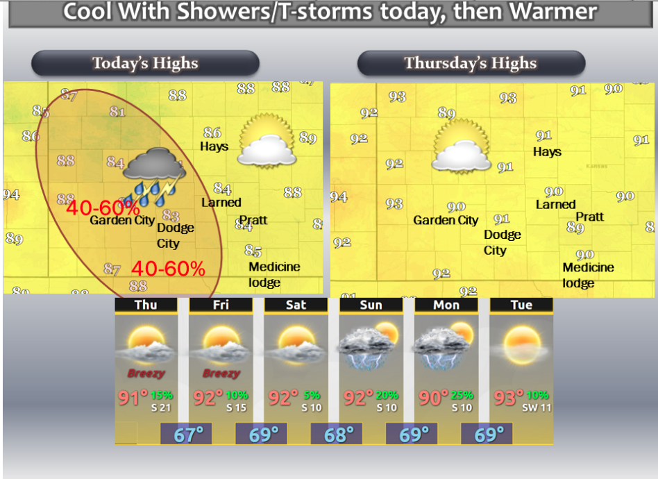
Friday NightMostly clear, with a low around 68. South southeast wind 9 to 11 mph.

SaturdaySunny, with a high near 94. South wind 9 to 14 mph.

Saturday NightMostly clear, with a low around 69.

SundayA 20 percent chance of showers and thunderstorms. Mostly sunny, with a high near 94.

Sunday NightA 30 percent chance of showers and thunderstorms. Mostly cloudy, with a low around 69.

MondayA 20 percent chance of showers and thunderstorms. Mostly sunny, with a high near 91.

Partly sunny, mild with a chance of thunderstorms


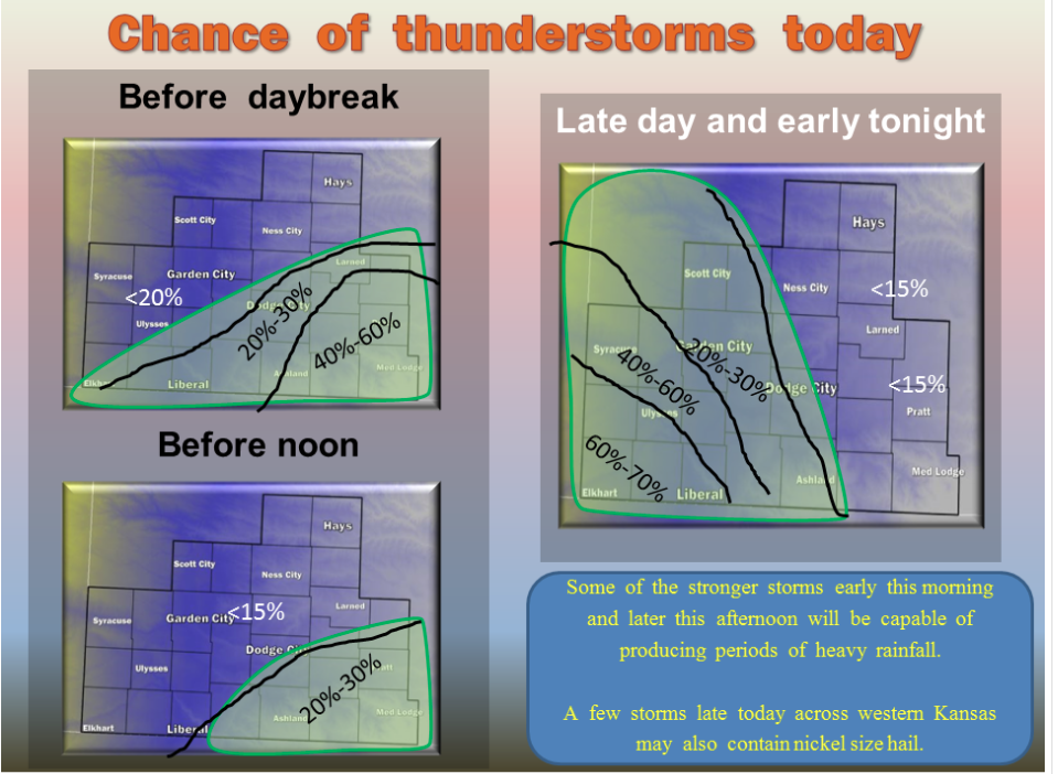
There is a good chance of showers and thunderstorms this morning across parts of southwestern Kansas. Severe weather is not expected but localized heavy rain is possible. The rain should taper off by noon or early afternoon. The heavier rain is not expected to make it as far east as Pratt, Medicine Lodge or Hays. Temperatures will be seasonal from Thursday through early next week, with small chances for thunderstorms by Sunday and Monday.

Screen Shot 2015-08-12 at 5.53.13 AMTodayA 20 percent chance of showers and thunderstorms after 1pm. Partly sunny, with a high near 87. Light south wind increasing to 6 to 11 mph in the morning.

TonightPartly cloudy, with a low around 65. South southeast wind 5 to 8 mph.

ThursdayMostly sunny, with a high near 91. South wind 7 to 14 mph.

Thursday NightA 20 percent chance of showers and thunderstorms after midnight. Mostly clear, with a low around 67. South southeast wind 7 to 13 mph.

FridayA 20 percent chance of showers and thunderstorms before 8am. Sunny, with a high near 94. South wind 5 to 11 mph.

Friday NightMostly clear, with a low around 68.

SaturdaySunny, with a high near 93.

Saturday NightMostly clear, with a low around 68.

SundayA 30 percent chance of showers and thunderstorms. Mostly sunny, with a high near 93.

Sunny, warm Tuesday


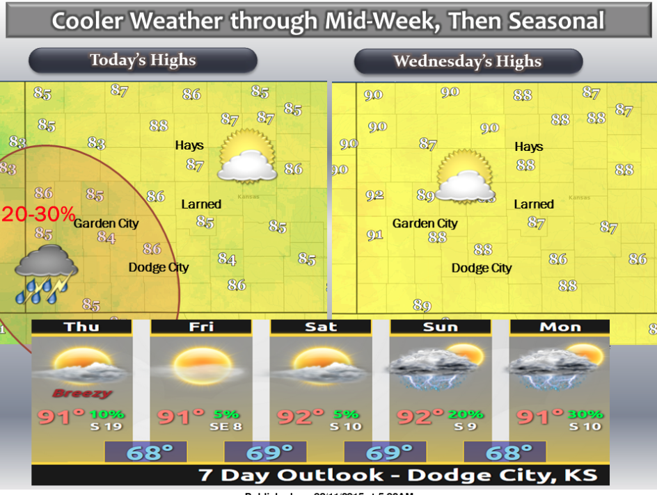
There is a chance of showers and thunderstorms today and tonight across parts of southwestern Kansas. Highs will top out in the mid 80s today and mainly upper 80s on Wednesday. Slight warmer temperatures can be expected starting Thursday and the next chance for thunderstorms will be late Sunday into Monday.

Screen Shot 2015-08-11 at 5.44.53 AMTodayMostly sunny, with a high near 87. East wind 5 to 8 mph.

TonightA 20 percent chance of showers and thunderstorms after 8pm. Partly cloudy, with a low around 65. East southeast wind 5 to 9 mph.

WednesdayMostly sunny, with a high near 89. South wind 6 to 13 mph.

Wednesday NightMostly clear, with a low around 66. South southeast wind 6 to 11 mph.

ThursdaySunny, with a high near 91. South wind 7 to 14 mph.

Thursday NightMostly clear, with a low around 68.

FridaySunny, with a high near 92.

Sunny, hot Monday with a chance of showers


Scattered thunderstorms possible this morning, mainly across south central Kansas. Another chance of thunderstorm will be possible across western Kansas later this afternoon and early tonight.

MondayA 10 percent chance of showers and thunderstorms before 7am. Mostly sunny, with a high near 89. Northeast wind 5 to Screen Shot 2015-08-10 at 5.47.14 AM15 mph.

Monday NightPartly cloudy, with a low around 64. East northeast wind 5 to 13 mph.

TuesdayA 20 percent chance of showers and thunderstorms after 4pm. Mostly sunny, with a high near 86. Light east wind increasing to 6 to 11 mph in the morning.

Tuesday NightA 30 percent chance of showers and thunderstorms, mainly after midnight. Mostly cloudy, with a low around 66. East southeast wind 5 to 8 mph becoming light and variable after midnight.

WednesdayA 20 percent chance of showers and thunderstorms. Mostly sunny, with a high near 88.

Wednesday NightPartly cloudy, with a low around 66.

ThursdaySunny, with a high near 91.

Thursday NightMostly clear, with a low around 68.

FridaySunny, with a high near 93.

Friday NightMostly clear, with a low around 69.

Strong storms roll across central Kansas

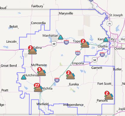
Westar power outage map 6:45 a.m. on Wednesday

MCPHERSON- Severe thunderstorms rolled south through central Kansas Wednesday morning. The storms brought heavy rain and wind gusts over 60 miles-per-hour. The National Weather Service issued flood warnings for Rice, Ellsworth, Saline and McPherson Counties.

Power lines are reported down in the Newton area.  Flooding is reported in several areas of McPherson County and street flooding is reported in the city of Lyons

Westar Energy reported a number of power outages across central Kansas from Salina to Wichita.

Officials will check for additional storm damage on Wednesday.


Partly sunny , warmer Wednesday


A warming trend is expected with storms possible by the weekend.

Screen Shot 2015-08-05 at 5.36.34 AMWednesdayAreas of dense fog before 10am. Otherwise, cloudy through mid morning, then gradual clearing, with a high near 89. North northeast wind 6 to 10 mph becoming east southeast in the afternoon.

Wednesday NightPartly cloudy, with a low around 67. East northeast wind 6 to 8 mph.

ThursdayMostly sunny, with a high near 96. Southeast wind 6 to 10 mph.

Thursday NightMostly clear, with a low around 68. Southeast wind 6 to 8 mph becoming northeast after midnight.

FridayMostly sunny, with a high near 96.

Friday NightA 40 percent chance of showers and thunderstorms. Mostly cloudy, with a low around 72.

SaturdayA 20 percent chance of showers and thunderstorms. Mostly sunny, with a high near 96.

Partly sunny, cooler with a chance for showers


There is a slight risk of severe thunderstorms tonight

Screen Shot 2015-08-04 at 5.36.50 AMTodayA 30 percent chance of showers and thunderstorms, mainly after 10am. Some of the storms could be severe. Partly sunny, with a high near 83. South southeast wind 5 to 13 mph.

TonightA 50 percent chance of showers and thunderstorms, mainly before 3am. Some of the storms could be severe. Mostly cloudy, with a low around 67. Southeast wind 7 to 11 mph.

WednesdayMostly sunny, with a high near 91. Southeast wind 7 to 9 mph becoming west northwest in the afternoon.

Wednesday NightMostly clear, with a low around 68. Northeast wind 6 to 10 mph becoming southeast after midnight.

ThursdaySunny, with a high near 95. Southeast wind 6 to 9 mph becoming east northeast in the afternoon.

Thursday NightA 20 percent chance of showers and thunderstorms. Partly cloudy, with a low around 69.

FridayMostly sunny, with a high near 94.

Sunny, hot with a chance for thunderstorms


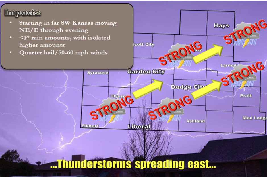
A thunderstorm complex will move across the region beginning this afternoon and through the evening.

Screen Shot 2015-08-03 at 5.39.21 AMTodayMostly sunny, with a high near 94. Light southeast wind becoming south southeast 6 to 11 mph in the morning.

TonightA 30 percent chance of showers and thunderstorms, mainly after 1am. Mostly cloudy, with a low around 68. South southeast wind 7 to 13 mph.

TuesdayA 50 percent chance of showers and thunderstorms. Mostly cloudy, with a high near 85. South wind 7 to 13 mph.

Tuesday NightA 30 percent chance of showers and thunderstorms, mainly before 2am. Mostly cloudy, with a low around 65. Southeast wind 5 to 10 mph.

WednesdayMostly sunny, with a high near 91. Northwest wind 6 to 9 mph.

Wednesday NightA slight chance of showers and thunderstorms between 1am and 3am. Partly cloudy, with a low around 68. Chance of precipitation is 20%.

ThursdayA 20 percent chance of showers and thunderstorms after 7am. Mostly sunny, with a high near 94.

Sunny, hot Friday


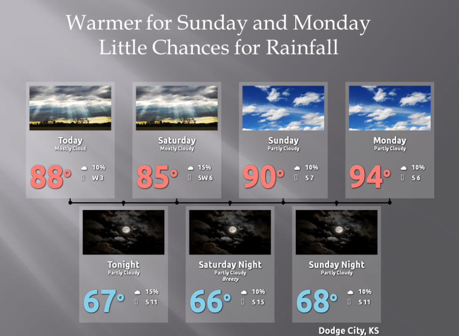
Rainfall chances will be minimal and mainly confined to areas south of Dodge City into Monday. Highs will warm to around 90 by Sunday, then into the mid 90s on Monday.

Screen Shot 2015-07-31 at 5.33.55 AMTodayMostly sunny, with a high near 90. Light and variable wind becoming south southeast 5 to 8 mph in the morning.

TonightPartly cloudy, with a low around 67. South southeast wind 7 to 10 mph.

SaturdayMostly sunny, with a high near 89. South southwest wind 7 to 13 mph.

Saturday NightPartly cloudy, with a low around 67. South southwest wind 7 to 13 mph.

SundayMostly sunny, with a high near 92. South wind 7 to 9 mph.

Sunday NightMostly clear, with a low around 69.

MondayMostly sunny, with a high near 95.

Partly sunny, cooler Wednesday

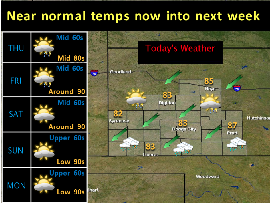
Scattered thunderstorms will be possible today, mainly across southern portions of the forecast area. Otherwise expect mostly cloudy skies south and partly cloudy skies north. Near normal temperatures are expected today through at least the first part of next week.

Screen Shot 2015-07-29 at 5.32.18 AMTodayPartly sunny, with a high near 85. North northeast wind 8 to 13 mph becoming east in the afternoon.

TonightA 20 percent chance of showers and thunderstorms after 10pm. Mostly cloudy, with a low around 63. Light east wind.

ThursdayA 20 percent chance of showers and thunderstorms. Partly sunny, with a high near 86. Southeast wind 5 to 8 mph.

Thursday NightA 20 percent chance of showers and thunderstorms. Partly cloudy, with a low around 64. Southeast wind 5 to 8 mph becoming south southwest after midnight.

FridayA 20 percent chance of showers and thunderstorms. Mostly sunny, with a high near 92. South southwest wind 5 to 8 mph.

Friday NightPartly cloudy, with a low around 65.

SaturdayA 20 percent chance of showers and thunderstorms. Mostly sunny, with a high near 92.

Copyright Eagle Radio | FCC Public Files | EEO Public File